
Today: Partly cloudy. Winds SW @ 10mph. High 68.
Tonight: P/Cldy. Low 42. SW @ 5-10.
Tomorrow: P/Cldy w/isolated showers. High around 70. W @ 10-15.
Thursday: P/Cldy. High near 70.
Friday: Mostly cloudy w/showers. High 61.
Monday’s High in Atlantic was 70. Our Low this morning, 30. Last year on this date, the High was 86 and the Low was 56. The Record High for April 21st in Atlantic, was 88 in 1980. The Record Low was 16 in 1907.
Today: Mostly cloudy with rain ending this morning; Becoming P/Cldy. High 65. SW-NW @ 10-20.
Tonight: Mostly clear. Low 35.
Tomorrow: P/Cldy. High 65. SW @ 10-15.
Wednesday: P/Cldy w/scattered afternoon showers. High 70.
Thursday: P/Cldy. High around 70.
Sunday’s High in Atlantic was 64. Our Low this morning, 42. We received .02″ rain at the KJAN studios through 5-a.m. today. Last year on this date, the High was 80 and the Low 31.
The Record High for April 20th in Atlantic, was 90 in 1902. The Record Low was 18 in 1956.
Today: Sunny, with a high near 59. North wind 10-20 mph.
Tonight: Partly cloudy w/a 30% chance of rain after midnight. Low around 37. New precipitation amounts of less than a tenth of an inch possible.
Monday: Mostly cloudy in the morning w/a 30% chance of rain; Gradually becoming sunny. High near 65. Winds becoming W/NW @ 15-25. New precipitation amounts of less than a tenth of an inch possible.
Monday Night: Mostly clear & breezy with a low around 36.
Tuesday: Sunny. High near 63. North wind 5 to 10 mph becoming west southwest in the afternoon.
Tuesday Night: Mostly clear, with a low around 45.
Wednesday: Partly sunny w/a 30% chance of rain during the afternoon. High near 73.
Saturday’s High in Atlantic was 69. Our Low was 35. Last year on this date, the High in Atlantic was 66 and the Low was 31. The Record High on April 19th was 87 in 1908 & 1946. The Record Low was 15, in 1988.
Today: Mostly sunny & breezy. High 64. W-SW winds @ 15-25 (w/gusts to around 30).
Tonight: Fair to partly cloudy. Low 38. Winds becoming Northerly @ 5-10.
Tomorrow: P/Cldy to Cldy. High 58. N @ 5-10.
Monday: Mostly cloudy. High 58.
Tuesday: P/Cldy. High 62.
Friday’s High in Atlantic was 46. Our Low was 28. Last year on this date, the High in Atlantic was 58 and the Low was 34. The Record High on April 18th was 89 in 1948. The Record Low was 17, in 1905.
**All Winter Weather Advisories and Watches have been cancelled***
Today: Mostly cloudy this morning w/light snow ending. Some areas of fog; Gradually becoming Partly cloudy. High 43. NW @ 5-10.
Tonight: Partly cloudy. Low around 29. South southwest wind 5-10 mph.
Saturday: Mostly Sunny & breezy. High near 60. SW @ 15-25 w/gusts to near 30.
Sunday: Becoming cloudy. High near 57. N/NE @ 10-20.
Monday: Mostly cloudy. High near 55.
Thursday’s High in Atlantic was 38. Our Low this morning was 29. We received 3.8″ of snow here at the KJAN studios Thursday afternoon into early this morning. Last year on this date, the High in Atlantic was 74 and the Low was 40. The Record High on April 17th was 85 in 2004. The Record Low was 11, in 1907.
(Radio Iowa) — We’re almost four weeks into spring but Iowa’s southern half is quickly looking more like mid-winter. Up to a foot of snow is in the forecast for some areas of Iowa today (Thursday) and a Winter Storm Warning is posted for two-dozen counties. Meteorologist Kenny Podrazik, at the National Weather Service, says snowplows are already out, working to keep the roads clear. “The heaviest snow is going to fall across far southern Iowa, the southern two tiers of rows towards the Missouri border,” Podrazik says. “There’s already been a couple of reports down there of two-to-five inches near Lamoni and there’s additional snow that’ll be falling throughout much of the day and into the afternoon.”
Just a few days ago, on Easter Sunday, parts of northern Iowa were walloped by record-setting snowfall, with the Emmet County town of Ringsted reporting 11-inches of snow. Podrazik says today’s snowfall could bring multiple new records, too, especially if the region sees a full foot of flakes fall.”Anywhere from Creston to Chariton, down to Lamoni, all the way to Ottumwa, even as far east as Burlington, they could definitely see eight to ten or even up to that 12-inch range,” Podrazik says. “It’s going to be that wet, sticky, sloppy snow. There’s definitely the potential it could stick to a lot of trees and power lines and maybe cause some issues with that.”
If you just don’t feel like shoveling that snow or maybe you’ve already drained the gas from your snowblower, never fear, as those deep drifts won’t last long. “We’ll have one more cold day tomorrow when we’ll be stuck in the 40s for much of the state and then we’ll be back up into the mid- to upper-50s around 60 on Saturday and Sunday,” Podrazik says, “and then even warmer on Monday and then Tuesday, we’re talking possibly mid-70s across central and southern Iowa.” Forecasters say the majority of northern Iowa should get missed by this snowstorm. The latest prediction calls for at least some snow to fall as far north as Carroll, Ames, Waterloo and Dubuque, while the worst of it should stay generally south of Interstate 80.
OMAHA, Neb. (AP) — Residents in Nebraska and Iowa are bracing for a spring snow storm that could drop three-quarters of a foot of snow in some places. Snow began falling overnight in western Nebraska, and is expected to continue throughout Thursday as the storm moves east across the state into Iowa. The National Weather Service has issued weather advisories for most of Nebraska until 7 p.m., and for the southern half of Iowa until 7 a.m. Friday. The service says a swath from Scottsbluff to Omaha could see up to 6 inches of snow, while Lincoln could get up to 8 inches. In Iowa, the service says some parts of southern Iowa could get up to 9 inches.
**Winter Weather Advisory for Cass-Adair-Madison-Audubon-Guthrie & Dallas Counties from Noon today until 7-a.m. Friday; and from now until 7-a.m. Friday for Harrison-Shelby-Pott. Counties**Winter Storm Warning for Mills-Montgomery-Fremont-Page Counties from now until 7-a.m. Friday, and from 9-a.m. Today until 7-a.m. Fri., for Adams-Union-Taylor-Ringgold Counties**
TODAY: Cloudy w/a light snow-rain mix. High 38. E @ 10-15 mph
TONIGHT: Cloudy w/snow ending by midnight. Low 28. NE @ 10-15. (Total snow 1-to 3”)
TOMORROW: P/Cldy. High 46. NW @ 10-15.
SATURDAY: P/Cldy. High 62.
SUNDAY: P/Cldy. High 57.
Wednesday’s High in Atlantic was 51. The Low was 20. We received a trace of snowfall overnight thru early this morning at KJAN. Last year’s High on this date was 78. The Low was 51. The record high on April 16th was 88 in 1898. The record low was 19 in 1988.
The National Weather Service in Johnston reports “Confidence in amounts and location are still on the low side as of today, but it appears winter will hold on for several more days with moderate snows expected across southern Iowa Thursday into Thursday Night. Details on exact amounts are uncertain, but it appears moderate accumulations are possible, potentially in the 3-6 inch range toward the Missouri border. 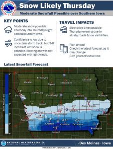 The good news is that winds will be light so blowing snow is not anticipated. The higher end of the potential range would occur mainly on grass and elevated surfaces, but higher snowfall rates could still lead to accumulations on roads and low visibilities presenting travel difficulties as well.”
Be sure to check the latest forecasts and road conditions over the next few days for updated information.


