
Audubon-Guthrie-Dallas-Cass-Adair-Madison-Adams-Union-Taylor-Ringgold-Counties:
…A FREEZE WARNING REMAINS IN EFFECT UNTIL 9 AM TODAY (Tuesday)…
…A FREEZE WARNING also REMAINS IN EFFECT FROM 12 AM WEDNESDAY UNTIL 9 AM WEDNESDAY…
For Pottawattamie-Mills-Fremont and Page Counties: …A FREEZE WARNING REMAINS IN EFFECT UNTIL 9 AM TODAY MORNING…The second FREEZE WARNING is in effect from 10-p.m. Tuesday through 9-a.m. Wednesday.
* WHAT…For this morning, temperatures of around or a few degrees below freezing are expected. For Wednesday morning, temperatures as low as the mid to upper 20s are expected.
* IMPACTS…Freezing conditions will damage sensitive vegetation.
PRECAUTIONARY/PREPAREDNESS ACTIONS…
Take steps now to protect tender plants from the cold. To prevent freezing and possible bursting of outdoor water pipes they should be wrapped, drained, or allowed to drip slowly.
Area Counties: Dallas-Cass-Adair-Madison-Adams-Union-Taylor-Ringgold (256 PM CDT Mon Apr 19 2021)
…FREEZE WARNING IN EFFECT FROM 12 AM until 9 AM TUESDAY…
…FREEZE WARNING IN EFFECT FROM 12AM Wednesday until 9 AM WEDNESDAY
Area Counties: Pottawattamie-Mills-Montgomery-Fremont-Page:
…FREEZE WARNING IN EFFECT FROM 10 PM MONDAY until 9 AM TUESDAY…
…FREEZE WARNING IN EFFECT FROM 10 PM TUESDAY TO 9 AM WEDNESDAY…
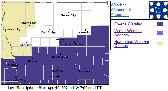 * WHAT…For the first Freeze Warning, sub-freezing temperatures as low as the upper 20s expected. For the second Freeze Warning,sub-freezing temperatures as low as middle to upper 20s expected.
* IMPACTS…Frost and freeze conditions will kill crops, other sensitive vegetation and possibly damage unprotected outdoor plumbing.
PRECAUTIONARY/PREPAREDNESS ACTIONS…
Take steps now to protect tender plants from the cold. To prevent freezing and possible bursting of outdoor water pipes they should be wrapped, drained, or allowed to drip slowly. Those that have in-ground sprinkler systems should drain them and cover above- ground pipes to protect them from freezing.
Today: Cloudy w/scattered light rain-snow. High around 40. N/NW @ 20-35 mph.
Tonight: Mo. Cldy w/light rain or flurries. Low 27. N @ 10-15.
Tomorrow: P/Cldy to Cldy w/scattered morning light snow/flurries. High 45. N @ 10-20.
Wednesday: P/Cldy to Cldy. High 47.
Sunday’s High in Atlantic was 63. Our Low this morning was 32. Last year on this date the High in Atlantic was 64 and the Low 29. The Record High on this date was 87 in 1908/1946, & 1987. The Record Low was 15 in 1988.
Area Counties: Along and mainly south of Interstate 80, including Pottawattamie, Cass, Adair, Madison, Mills, Montgomery, Adams, Union, Fremont, Page, Ringgold, Taylor, and Dallas.
The National Weather Service has issued a FREEZE WATCH in effect, primarily from 7-p.m. Tuesday through 10-a.m. Wednesday in most counties.
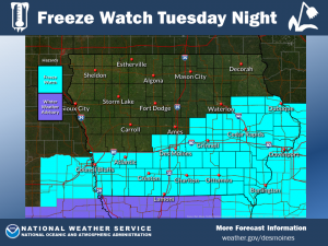 * WHAT…After light snow accumulations over the south tonight into Tuesday morning, cold air will follow with sub-freezing temperatures as low as 28 possible Tuesday night into Wednesday
morning.
* IMPACTS…Frost and freeze conditions could kill sensitive vegetation and possibly damage unprotected outdoor plumbing.
PRECAUTIONARY/PREPAREDNESS ACTIONS…
Take steps now to protect tender plants from the cold. To prevent freezing and possible bursting of outdoor water pipes they should be wrapped, drained, or allowed to drip slowly. Those that have in-ground sprinkler systems should drain them and cover above-ground pipes to protect them from freezing.
Today: Mostly cloudy, then gradually becoming sunny, with a high near 65. West wind 5 to 11 mph.
Tonight: Partly cloudy, with a low around 36. West southwest wind 6 to 9 mph becoming north after midnight.
Monday: Showers likely, mainly after 3pm. Mostly cloudy, with a high near 43. Breezy, with a north wind 13 to 17 mph, with gusts as high as 22 mph. Chance of precipitation is 60%. New precipitation amounts of less than a tenth of an inch possible.
Monday Night: Rain likely, possibly mixed with snow showers before 9pm, then a chance of snow showers. Mostly cloudy, with a low around 29. North wind 6 to 10 mph. Chance of precipitation is 60%. New snow accumulation of around an inch possible.
Tuesday: A slight chance of rain and snow showers before noon, then a slight chance of rain showers between noon and 1pm. Mostly cloudy, with a high near 46. North wind 6 to 13 mph, with gusts as high as 22 mph. Chance of precipitation is 20%.
Wednesday: Mostly sunny, with a high near 49.
saturday’s High in Atlantic was 60. Our Low this morning, was 41. We received just a Trace of rain in Atlantic, Saturday. Last year on this date the High in Atlantic was 69 and the Low 35. The Record High on this date was 89 in 1948. The Record Low was 17 in 1905.
Today: Mostly cloudy w/light rain/drizzle ending this morning. Becoming P/Cldy. High 50. N @ 10-15.
Tonight: P/Cldy. Low 32.
Tomorrow: P/Cldy. High 60. W @ 10.
Monday: Mo. Cldy w/scattered rain. High 48.
Tuesday: P/Mo. Cldy w/light rain-snow, early. High near 46.
Friday’s High in Atlantic was 49. Our Low this morning, 41. We received .19” rain in Atlantic Friday and overnight. Last year on this date the High in Atlantic was 46 and the Low 28. The Record High on this date was 85 in 2004. The Record Low was 11 in 1907.
Today: Partly-to-Mostly cloudy w/a slight chance of light rain late in the day. High 52. SE @ 5-10.
Tonight: Light rain or showers. Low around 37. N @ 5-10. New precipitation amounts between a tenth and quarter of an inch possible.
Saturday: Mostly cloudy early, w/light rain ending in the morning, then becoming P/Cldy. High near 50. N @ 10.
Sunday: P/Cldy. High around 58.
Monday: Mo. cldy w/scattered light rain/showers. High near 50.
Thursday’s High in Atlantic was 54. Our Low was 32. Last year on this date, the High in Atlantic was 38 and the Low was 28. The Record High was 88 in 1898. The Record Low was 19 in 1988.
Today: **Freeze warning until 8-a.m.** Partly cloudy. High 56. NW @ 10-15.
Tonight: P/Cldy. Low 32. Winds light & variable.
Tomorrow: P/Cldy to cldy w/a chance of showers late. High 54. SE @ 5-10.
Saturday: Mostly cloudy w/a light rain in the morning; Becoming P/Cldy. High near 50.
Sunday: P/Cldy. High around 60.
Wednesday’s High in Atlantic was 51. Our Low this morning, 27. Last year on this date the High in Atlantic was 51 and the Low 20. The Record High on this date was 84 in 1920. The Record Low was 17, in 1926 & 1962.
Today: **FROST ADVISORY until 8-a.m.** Partly cloudy & breezy. High around 54. NW @ 10-20.
Tonight: P/Cldy. Low 27 w/widespread frost possible, mainly after 1am. Low around 27. NW @ 5.
Tomorrow: P/Cldy. High near 57. NW @ 10.
Friday: Mostly cloudy w/a chance of light showers in the afternoon. High near 50.
Saturday: Mostly cloudy, with a chance of morning showers. High 48.
Tuesday’s High in Atlantic was 54. Our Low this morning, 27. Last year on this date the High in Atlantic was 46 and the Low 16. The Record High on this date was 89 in 2003. The Record Low was 11 in 1907.
Today: Partly cloudy & windy. High 56. Winds NW @ 15-25 mph.
Tonight: Fair to P/Cldy. Low 30. NW @ 5-10.
Tomorrw: P/Cldy. High 55. NW @ 10-20.
Thursday: P/Cldy. High 58.
Friday: Mostly cloudy. High 55.
Monday’s High in Atlantic was 58. Our Low this morning, 28. Last year on this date, the High in Atlantic was 41 and the Low was 22. The Record High was 88 in 2006, and the Record Low was 11 in 1950.


