
Severe Thunderstorm Warning
National Weather Service Des Moines IA
705 PM CDT Tue May 25 2021

The National Weather Service in Des Moines  has issued a

* Severe Thunderstorm Warning for...
  Southeastern Greene County in west central Iowa...
  Northeastern Guthrie County in west central Iowa...
  Southwestern Boone County in central Iowa...
  Northwestern Dallas County in central Iowa...

* Until 745 PM CDT.

* At 705 PM CDT, a severe thunderstorm was located near Lake
  Panorama, or 11 miles northeast of Guthrie Center, moving east at
  35 mph.

  HAZARD...Quarter size hail.

  SOURCE...Radar indicated.

  IMPACT...Damage to vehicles is expected.

* Locations impacted include...
  Perry.

PRECAUTIONARY/PREPAREDNESS ACTIONS...

For your protection move to an interior room on the lowest floor of a
building.
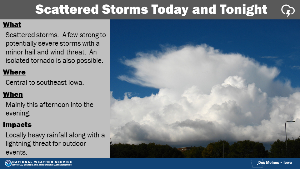
The National Weather Service in Des Moines, says “While a few showers and storms are expected this morning, better coverage is forecast by this afternoon and evening as a cold front passes through the state. A few strong to potentially severe storms are possible by later today with the main concerns from hail approaching 1 inch in diameter and strong gusty winds. An isolated tornado is also possible. Locally heavy rainfall and frequent lightning will also accompany the storms.
 Storms will move into western Iowa very late Wednesday night and continue through the rest of the state on Thursday. The threat of severe weather continues across the southern half of the state with hail and damaging winds the main concern. An isolated tornado remains possible as well. Locally heavy rainfall could also cause flooding in urban areas. This is still a few days out and details may change, so stay tuned for updates as the forecast is fine tuned.”
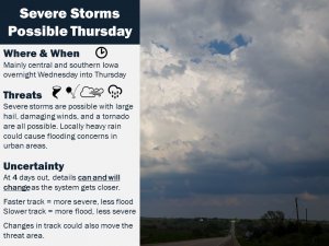
Today: Partly cloudy to cloudy w/scattered showers & thunderstorms. High near 80. SW winds @ 10-20 mph.
Tonight: Showers ending; PCldy. Low 54. NW @ 10-15.
Tomorrow: P/Cldy. High 78. N winds becoming E @ 10.
Thursday: Mo. cldy w/showers & tstrms. High 73.
Friday: P/Cldy. High 68.
Monday’s High in Atlantic was 83. Our Low this morning, 67. Last year on this date (May 25), the High in Atlantic was 75 and the Low was 63. The Record High was 98 in 19679, and the Record Low was 30, in 1925.
Today: Partly cloudy to cloudy w/scattered showers this morning & again later this afternoon. High 82. S @ 10-20.
Tonight: P/Cldy to Cldy w/scatt. shwrs. Low 45. S @ 10.
Tomorrow: P/Cldy to Cldy w/scatt. shwrs. High 82. SW @ 10-20.
Wednesday: P/Cldy. High 80.
Thursday: Mo. Cldy w/showers & thunderstorms. High 73.
Sunday’s High in Atlantic was 82. Our Low this morning, 65. We received .03″ rain between 6-am and 7-a.m. today. Last year on this date (May 24), the High in Atlantic was 79 and the Low was 63. The Record High was 101 in 1939, and the Record Low was 33, in 1924.
Today: Isolated showers and thunderstorms between 1pm and 4pm. Mostly cloudy, with a high near 79. South southwest wind 6 to 13 mph. Chance of precipitation is 20%.
Tonight: A 20 percent chance of showers and thunderstorms after 2am. Mostly cloudy, with a low around 66. South wind 11 to 14 mph, with gusts as high as 21 mph.
Monday: A 40 percent chance of showers and thunderstorms, mainly after 1pm. Mostly cloudy, with a high near 80. Breezy, with a south southwest wind 10 to 17 mph, with gusts as high as 25 mph. New rainfall amounts of less than a tenth of an inch, except higher amounts possible in thunderstorms.
Monday Night: A chance of showers and thunderstorms, then showers likely and possibly a thunderstorm after 1am. Mostly cloudy, with a low around 62. South wind 10 to 14 mph, with gusts as high as 21 mph. Chance of precipitation is 60%. New rainfall amounts of less than a tenth of an inch, except higher amounts possible in thunderstorms.
Tuesday: A 50 percent chance of showers and thunderstorms. Partly sunny, with a high near 80. South southwest wind 10 to 14 mph, with gusts as high as 21 mph. New rainfall amounts of less than a tenth of an inch, except higher amounts possible in thunderstorms.
Wednesday: A 20 percent chance of showers after 1pm. Mostly sunny, with a high near 80.
Saturday’s High in Atlantic was 78. Our Low this morning, 65. We received .07″ rain Saturday. Last year on this date (May 23), the High in Atlantic was 82 and the Low was 60. The Record High was 97 in 1939, and the Record Low was 26, in 1963.
Today: Partly cloudy skies. A few isolated showers and thundershowers possible this afternoon. S@ 10-20 High 81
Tonight: Partly cloudy skies. A few isolated showers and thundershowers. S@ 10 Low 66
Sunday: Partly cloudy skies. A few isolated showers and thundershowers, but dry much of the time. S@ 10-20 High 81
Monday: Partly cloudy skies. A few isolated showers and thunderstorms. High 81
Tuesday: Partly to mostly cloudy. A better chance for more widespread rain and thunderstorms. High 80
Today: Partly cloudy to cloudy skies. A few isolated showers possible early in the day, then a few isolated showers and thunderstorms developing mid to late afternoon. S @ 10-20 High 78
Tonight: Partly cloudy to cloudy skies. Any scattered showers and thunderstorms ending. S @10 Low 66
Saturday: Partly cloudy skies. A few isolated showers and thunderstorms. S @ 10-20 High 80
Sunday: Partly cloudy skies. A Few isolated showers and thunderstorms. High 82
Monday: Partly cloudy skies. A few isolated showers and thunderstorms. High 82
Today: Partly cloudy to cloudy skies. Rain ending this morning. Some scattered thunderstorms could redevelop this afternoon. South winds @ 10-20 High 75
Tonight: Partly cloudy to cloudy skies. Scattered thunderstorms. South winds @10 Low 65
Friday: Partly cloudy to cloudy. Scattered thunderstorms in the morning. South winds @ 10-20 High 78
Saturday: Partly cloudy to cloudy skies. Chance of thunderstorms. High 82
Sunday: Partly cloudy to cloudy. Chance of thunderstorms. High 82


