
Today: Mostly sunny. High 59. Wind North @ 10 mph.
Tonight: Mostly clear. Low 30. Winds light & variable.
Tomorrow: Partly cloudy. High 60. SE @ 10-15.
Thursday: Mo. Cloudy w/light rain. High 56.
Friday: Mo. Cldy. High 60.
Yesterday’s High in Atlantic was 71. Our Low this morning was 30. Last year on this date our High was 64 and the Low was 40. The record High in Atlantic on this date was 81 in 1901 & 1991. The Record Low was 13 in 1895.
Today: Partly cloudy. High 65. N @ 5-10.
Tonight: Mostly clear. Low 32.
Tomorrow: Mostly sunny. High 58. E @ 5-10.
Wednesday: P/Cldy. High 60.
Thursday: Mostly cloudy w/light showers. High 56.
Yesterday’s High in Atlantic was 65. Our Low was 30. Last year on this date our High was 69 and the Low was 43. The record High in Atlantic on this date was 87 in 1895. The Record Low was 15 in 1976.
Today: Sunny & windy. High near 62. South-southwest winds 10-15 this morning, increasing from 15-30 mph this afternoon.
Tonight: Mostly clear, with a low around 39. S/SW wind 5 to 10 mph becoming light and variable after midnight.
Monday: Sunny, with a high near 62. North wind 5 to 10 mph.
Monday Night: Clear, with a low around 34. N/NW wind around 5 mph.
Tuesday: Sunny, with a high near 54. Northeast wind 5 to 10 mph.
Tuesday Night: Mostly clear, with a low around 33.
Wednesday: Mostly sunny, with a high near 52.
Saturday’s High in Atlantic was 54. Our overnight Low was 24. Last year on this date the High in Atlantic was 74 and the Low was 45. The All-Time Record High on this date was 87 in 1947, and the Record Low was 13 in 1930.
Today: Partly Cloudy. High 53. NW @ 15-25.
Tonight: Mostly clear. Low 25. Winds light & variable.
Tomorrow: Mostly sunny. High 65. NW @ 10-20.
Sunday: Mostly sunny. High 65. SW @ 10-20.
Monday: P/Cldy. High 65.
Tuesday: P/Cldy. High 62.
Yesterday’s High in Atlantic was 72. Our Low this morning was 40. Last year on this date our High was 76 and the Low was 55. The record High in Atlantic on this date was 87 in 1947 & 2003. The Record Low was 14 in 1960.
Today: Mostly cloudy w/scattered light showers this morning; Becoming Partly Cloudy. High 69. SW-NW @ 10-20.
Tonight: P/Cldy. Low 38. NW @ 10-20.
Tomorrow: P/Cldy. High 53. NW @ 10-20.
Sunday: Mostly sunny. High 65.
Monday: P/Cldy. High 67.
Yesterday’s High in Atlantic was 69. Our 24-hour Low was 43. We received .02″ rain overnight through 5:45-a.m., today. Last year on this date our High was 77 and the Low was 39. The record High in Atlantic on this date was 88 in 2003. The Record Low was 12 in 1972.
Today: Mostly sunny. High 67. SW @ 10-20.
Tonight: Becoming mostly cloudy. Low 50. S @ 10-15.
Tomorrow: Mo. cldy w/scattered light rain. High 63. SW-NW @ 10-20.
Saturday: P/Cldy. High 52.
Sunday: P/Cldy. High 62.
Yesterday’s High in Atlantic was 61. Our 24-hour Low thru early this morning, 32. Last year on this date our High was 74 and the Low was 39. The record High in Atlantic on this date was 86 in 2003. The Record Low was 17 in 1952.
WASHINGTON (AP) — Over the past few decades tornadoes have been shifting — decreasing in Oklahoma, Texas and Kansas but spinning up more in states along the Mississippi River and farther east, a new study shows. Scientists aren’t quite certain why. Tornado activity is increasing most in Mississippi, Arkansas, Tennessee, Louisiana, Alabama, Kentucky, Missouri, Illinois, Indiana, Wisconsin, Iowa and parts of Ohio and Michigan, according to a study in Wednesday’s journal Climate and Atmospheric Science. There has been a slight decrease in the Great Plains, with the biggest drop in central and eastern Texas. Even with the decline, Texas still gets the most tornadoes of any state.
The shift could be deadly because the area with increasing tornado activity is bigger and home to more people, said study lead author Victor Gensini, a professor of atmospheric sciences at Northern Illinois University. Also more people live in vulnerable mobile homes and tornadoes are more likely to happen at night in those places, he said. Even though Texas, Kansas and Oklahoma get many more tornadoes, the four deadliest states for tornadoes are Alabama, Missouri, Tennessee and Arkansas, according to the National Oceanic and Atmospheric Administration.
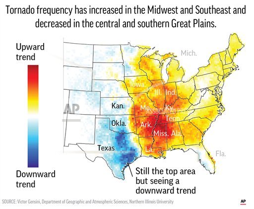
A new study finds that tornado activity is generally shifting eastward.
Because tornadoes sometimes go undercounted, especially in the past and in less populous areas, scientists don’t like to study trends by using counts of tornadoes. Gensini and tornado scientist Harold Brooks of the National Severe Storms Lab looked at “significant tornado parameters,” a measurement of the key ingredients of tornado conditions. It looks at differences between wind speed and direction at different altitudes, how unstable the air is and humidity. The more of those three ingredients, the more likely tornadoes will form. The increases in this measurement mirrored slightly smaller increases found in number of twisters. The study looked at changes since 1979. Everywhere east of the Mississippi, except the west coast of Florida, is seeing some increase in tornado activity. The biggest increase occurred in states bordering the Mississippi River.
Overall there is a slight increase in tornado activity, but it’s not too much and not nearly like what’s happening in the east, Gensini said. Why is this happening? “We don’t know,” Gensini said. “This is super consistent with climate change.” As the Great Plains dry out, there’s less moisture to have the type of storms that spawn tornadoes, Gensini said. Tornadoes form along the “dry line” where there are more thunderstorms because there’s dry air to the west and moist air from the Gulf of Mexico to the east. That dry line is moving east. “This is what you would expect in a climate change scenario, we just have no way of confirming it at the moment,” Gensini said.
Gensini said unless there are specific detailed studies, he and others cannot say this is caused by global warming, just that it looks like what is expected. Pennsylvania State University meteorology professor Paul Markowski, who wasn’t part of the research, praised the study as careful and well done.
Today: Mostly sunny. High 58. NW @ 10 mph.
Tonight: Clear. Low 33. S @ 5.
Tomorrow: Partly cloudy. High 63. SW @ 10-20.
Friday: Mostly Cldy w/scattered light rain. High near 60.
Saturday: P/Cldy. High 52.
Yesterday’s High in Atlantic was 66. Our 24-hour Low thru early this morning, 33. Last year on this date our High was 72 and the Low was 48. The record High in Atlantic on this date was 87 in 1947 & 2016. The Record Low was 12 in 1976.
Today: Mostly sunny. High 60. /NW @ 15-25mph.
Tonight: Fair to partly cloudy. Low 35. NW @ 5-10.
Tomorrow: Mo. Sunny. High 56. N @ 5-10.
Thursday: P/Cldy. High 62.
Friday: Mostly Cldy w/scattered light rain. High near 56.
Yesterday’s High in Atlantic was 48. Our 24-hour Low thru early this morning, 29. Last year on this date our High was 71 and the Low was 31. The record High in Atlantic on this date was 87 in 1921. The Record Low was 20 in 1976 & ’77.
(Radio Iowa) — We’re not even a month into fall and already wintry weather is hitting Iowa. Meteorologist Brooke Hagenhoff, at the National Weather Service, says the Sunday afternoon snowfall took some north-central Iowans by surprise. “The highest amounts we got were around Iowa Falls where they got around two-and-a-half inches,” Hagenhoff says. “There were two inches in the Emmet County-Estherville area, but Iowa Falls generally got the most yesterday while other places saw an inch to maybe just a dusting.”
Anyone in the region who’d hoped to build a snowman or go sledding had better act fast as the snow won’t last. “No, definitely not,” Hagenhoff says. “We’re expected to warm up gradually throughout the week. By Thursday to Friday, we should be in the upper 50s to right around 60.” Some social media chatter makes it sound like this taste of winter weather is closer to the end of the world, but she says a light snow during October is relatively typical. “Our average high for this time of year is right around 60 to 65 degrees, but looking back at our records all the way back to 1885, the average first trace of snow and first measurable snow both occur in October,” Hagenhoff says. “So, while it tends to catch people off guard, it’s not completely rare.”
In some areas, the snow fell on trees that were still fully leafed out and limbs snapped under the weight, dropping on power lines. In the Omaha-Council Bluffs area, as many as 50-thousand customers lost electricity on Sunday due to falling, snow-covered limbs.


