
Pottawattamie-Mills-Fremont-Montgomery Counties...
932 AM CST FRI NOV 9 2018

...A SNOW SQUALL WILL AFFECT NORTHWESTERN FREMONT...WEST CENTRAL
MONTGOMERY...MILLS...WESTERN POTTAWATTAMIE...SARPY...SOUTHEASTERN
LANCASTER...NORTHWESTERN JOHNSON...OTOE...SOUTHEASTERN DOUGLAS...
NORTHEASTERN GAGE AND CASS COUNTIES...

At 928 AM CST, a snow squall was located along I-80 from Lincoln to
Omaha. The band of snow was moving southeast at 40 mph.

Locations impacted include...
Southeastern Omaha, southeastern Lincoln, Council Bluffs, Bellevue,
Papillion, La Vista, Plattsmouth, Ralston, Glenwood, Syracuse,
Hickman, Springfield, Malvern, Louisville, Weeping Water, Treynor,
Underwood, Bennet, Elmwood and Firth.

This includes the following highways...
 Interstate 29 between mile markers 15 and 58.
 Interstate 80 in Iowa between mile markers 1 and 17.
 Interstate 80 in Nebraska between mile markers 414 and 428, between
mile markers 435 and 444, and between mile markers 448 and 454.

Visibilities will drop quickly to near zero in this squall.

Use extra caution if you must travel into or through this dangerous
snow squall. Rapid changes in visibility and potentially slick roads
are likely to lead to accidents. Consider delaying travel until the
squall passes your location.
Monona-Harrison-Shelby-Pottawattamie-Mills-Montgomery-Fremont and Page Counties…
6:00 AM CST Fri Nov 9 2018
…SNOW PUSHING THROUGH THIS MORNING WITH GUSTY WINDS DEVELOPING…
An area of snow is expected to push southeast across east central Nebraska and parts of southwest Iowa this morning. Snow amounts from 1 to 2 inches are possible. Strong north or northwest winds
are also expected to develop later this morning. The winds could gust to around 40 mph, creating some blowing snow and reduced visibilities for a few hours.
Drive with caution and allow extra time for travel.
Today: Mostly cloudy & windy, w/light snow or flurries (through early afternoon). High 26. NW @ 15-30 mph. Wind chill around 5 degrees. New snow accumulation of less than 1/2 inch is expected.
Tonight: Clearing skies. Low 8. N/NW winds @ 15-25mph diminishing overnight.
Saturday: Partly cloudy. High 34. S @ 10-15.
Sunday: P/Cldy to Cldy. High 39.
Monday: P/Cldy. High around 36.
Yesterday’s High in Atlantic was 34. Our Low this morning, 23. We received a Trace of snowfall Thursday night in Atlantic. Last year on this date our High was 36 and the Low was 16. The record High in Atlantic on this date was 73 in 1999. The Record Low was 8 in 1973.
By The Associated Press —
Authorities say several inches of snow have fallen in much of southern Nebraska. The Nebraska Transportation Department said Thursday that Interstate 80, highways and county roads are covered with snow in much of south-central Nebraska, making driving hazardous. Weather-related accidents have been reported in Grand Island and several other communities. The National Weather Service has issued a winter storm warning for Gosper, Phelps, Kearney, Furnas and Harlan counties, saying that up to 3 more inches could fall.
(Radio Iowa) — Iowans who are prepping their cars for winter may top off the antifreeze level in their engine, but the experts at the Iowa Poison Control Center remind, be careful with those chemicals. Registered Nurse Jean Hammack says antifreeze comes in an array of colors, including green, blue, pink and green, but all of them are hazardous if swallowed.
“That usually contains ethylene glycol which is highly toxic to the kidney and the lung,” Hammack says. “The other one we get concerned about is windshield wiper solution. That is often a blue color and contains a chemical called methanol which is also highly toxic, primarily to the retina in the eye.”
It’s best to leave antifreeze and wiper solution in the original gallon bottles, she says. After using part of the product, don’t transfer it to a smaller bottle, especially one that once contained juice or a sports drink. “It looks very similar to the blue-colored juices like Gatorade products,” she says. “If it’s sitting out in the garage and a little one comes along and little animals, little pets come along, yes, we do get a fair number of calls and it is highly toxic.”
Because of the color and sweet taste, children often mistake these chemicals for drinks, while pets may lick up spilled fluid from the floor. Hammack says to keep the poison center number programmed into your phone — 1-800-222-1222.
The National Weather Service in Des Moines has updated their statement put out Wednesday, with regard to winter weather affecting the State today and Friday. Officials say a couple rounds of wintry precipitation are expected this afternoon into Friday. The first round will bring mainly light snow spreading into western Iowa this afternoon, with the snow then spreading across all of Iowa tonight. The highest accumulations with the first round are expected along and south of Interstate 80, with anywhere from 1-to 2-inches in Atlantic and most areas, and 2-to 3-inches further east, toward Greenfield and Winterset.
The second round will move through Friday morning into Friday afternoon across the western/southern half of the state. This round may have brief snow bursts resulting in brief periods of significantly reduced visibilities. Gusty northwest winds are also anticipated which may lead to patchy blowing and drifting snow, also impacting visibilities at times. Slick roads will be possible with both snow chances. Please slow down and take your time when traveling in the snow, leave extra distance between your vehicle and other vehicles on the road.

click on the map to enlarge
Today: Mostly cloudy w/a 50% chance of snow, mainly after 2-p.m. High 34. E @ 5-10. Daytime snow accumulation of around 1″ is possible.
Tonight: Mo. cloudy w/light snow or flurries (less than 1/2″ additional accum.). Low 20. NW @ 10-20.
Tomorrow: Mo. cloudy. High 26. NW @ 15-25. Wind chill around 5 degrees.
Saturday: P/cldy. High 36.
Sunday: P/Cldy to Cldy. High 36.
Yesterday’s High in Atlantic was 38. Our Low this morning, 24. Last year on this date our High was 49 and the Low was 16. The record High in Atlantic on this date was 80 in 1999 & 2006. The Record Low was -12 in 1991.
The National Weather Service says there will be two separate rounds of wintry precipitation in Iowa from Thursday into Friday. The first round will have precipitation spreading into the southern two-thirds of the state Thursday afternoon and evening. The precipitation may begin as rain before transitioning to snow by Thursday evening and ending around midnight. Cass and surrounding counties can expect anywhere from one-to two-inches on the ground by the time the snowfall ends.
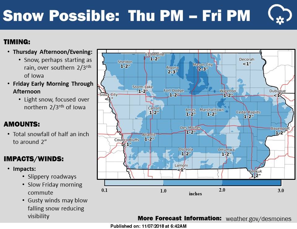
click on the image to enlarge
The next round of snow will arrive over northern Iowa early Friday morning and slide southeastward into east central Iowa. Gusty winds will accompany this snow and cause blowing of the falling snow, which may reduce visibility. This snow may impact the Friday morning commute with slippery, snow covered roads. The highest snowfall amounts will be over northern Iowa where around two-inches of snow may fall.
Today: Partly cloudy. High near 40. NW @ 10-20 mph
Tonight: Clear to P/Cldy. Low 22. Winds light & variable.
Tomorrow: Mostly cloudy w/a light rain-snow mix in the afternoon. High 36. E @ 5-10.
Friday: Cloudy & windy, w/light snow or flurries. High 40.
Saturday: P/Cldy. High near 40.
Yesterday’s High in Atlantic was 44. Our Low this morning, 24. Last year on this date our High was 44 and the Low was 15. The record High in Atlantic on this date was 77 in 1915. The Record Low was -14 in 1991.


