
Today: Mostly cloudy w/flurries this morning; Partly cloudy this afternoon. High 16. NW @ 15-25.
Tonight: P/Cldy. Low -2. Winds light & variable.
Tomorrow: Mo. Cldy w/flurries. High 22.
Friday: Mo. Cldy w/light snow during the afternoon. High 26.
Saturday: Mo. Cldy, windy & cold. High 14.
Yesterday’s High in Atlantic was 21. Our Low was 4. Last year on this date our High was 62 and the Low was 33. The record High in Atlantic on this date was 71 in 2016. The Record Low was -16 in 1960.
Today: Partly cloudy to cloudy w/occasional, scattered flurries. High 18. NE @ 10-15.
Tonight: Mostly cloudy w/flurries. Low 10. E @ 5-10.
Tomorrow: P/Cldy to Cldy. High 18. N @ 10-20.
Thursday: Mo. Cldy w/flurries. High 22.
Friday: Mo. Cldy w/light snow during the afternoon. High 26.
Yesterday’s High in Atlantic was 15. Our Low was -9. Last year on this date our High was 53 and the Low was 28. The record High in Atlantic on this date was 72 in 1896. The Record Low was -28 in 1963.
The National Weather Service is calling this Winter season “Relentless,” especially when it comes to expected Wind Chill temperatures. Tuesday morning, wind chills across southern Iowa will range from -5 to -15 degrees, with -20 to -30 expected roughly north of Highway 30. By Sunday morning, the Wind Chill Index (https://www.weather.gov/bou/windchill), or, how cold it feels with the air temperature and wind factored-in, is expected to be in the -27 degree range from I-80 south, to the lower to mid-minus 30 degree range from I-80 north all the way to northern Iowa, with -35 expected for Estherville and Mason City.
The wind chill index takes into account heat loss from the human body to its surroundings during cold and windy weather. Wind chill values near minus 25 degrees mean that frostbite is possible within 15 minutes.
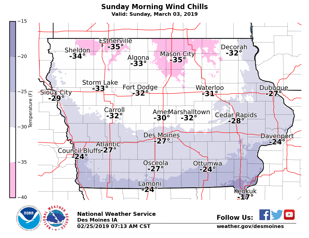
Projected Wind Chill readings Sunday, March 3rd
(Radio Iowa/KJAN weather date) — A blizzard and treacherous travel conditions struck much of the state this weekend. Snow plows were pulled from areas of northern Iowa Saturday night. The Iowa D-O-T closed Interstate-35 from the Ames exit all the way to the Minnesota border on Sunday morning. Rescue crews struggled to reach stranded motorists. Wright County Emergency Management director Jim Lester says road crews in his county will set out this (Monday) morning after the winds subside. “It’s going to be a chore for them,” he said. “Several of the roads are (drifted) completely shut.”
Hamilton County engineer Nikki Stinn said snow plows went out at noon Sunday to help clear paths to rescue motorists, but the plows were pulled off the roads after all rescues were completed. “It’s just too much (blowing snow), too unsafe to be out there trying to clear roads,” she said.
Buffalo Center seems to have had the most snow from this weekend’s storm — 15 inches. The National Weather Service announced early Sunday morning this is the snowiest February on record at the Des Moines Airport. There’s been more than 24 inches — that’s two feet — of snow in the capital city. Here in Atlantic, we’ve received 30.3 inches of snow since the beginning of the month. At Eppley Airport in Omaha, there’s been more than 44 inches of snow since December 1st. That shatters a record set during the winter of 2003 and 2004. If Omaha gets another two-tenths of snow this week, it will set the all-time snowiest February record as well.
Today: Partly cloudy. High 18. N @ 10-15.
Tonight: P/Cldy. Low 0. NE @ 5.
Tomorrow: Mostly cloudy w/flurries. High 20. E @ 10.
Wednesday: Mo. Cldy w/flurries. High 22.
Thursday: P/Cldy. High 25.
Yesterday’s High in Atlantic was 19. Our Low this morning, -9. Last year on this date our High was 42 and the Low was 22. The record High in Atlantic on this date was 70 in 1995. The Record Low was -12 in 2014.

Podcast: Play in new window | Download (832.2KB)
Subscribe: RSS
Today: **Winter Weather Advisory until 9-a.m.**Cloudy w/light freezing rain/drizzle changing to snow this afternoon. High 37 through late this morning, w/the temp nearly steady to slowly falling during the afternoon. E/NE winds @ 10-20 mph. New ice accumulation of less than a 0.1 of an inch possible. New snow and sleet accumulation of 1 to 3 inches possible.
Tonight: **Blizzard Warning in effect from 6-p.m. through 6-p.m. Sunday** Cloudy w/snow/blowing snow. N @ 20-40+mph. Low 18. Wind chill values as low as zero. New snow accumulation of 3 to 7 inches possible.
Tomorrow: ***Blizzard warning continues until 6-p.m.** Morning flurries. Cloudy to P/Cldy. High 22. NW @ 20-40+ mph. Wind chill values as low as -5. *******Total Snowfall 4-to 8-inches expected.
Monday: P/Cldy to Cldy w/flurries. High 20.
Tuesday: P/Cldy to Cldy. High 27.
Yesterday’s High in Atlantic was 34. Our Low was 12. We received 1/10th of an inch of freezing drizzle/rain overnight (.02” liquid). Last year on this date our High was 32 and the Low was 20. The record High in Atlantic on this date was 65 in 2002. The Record Low was -22 in 1989.
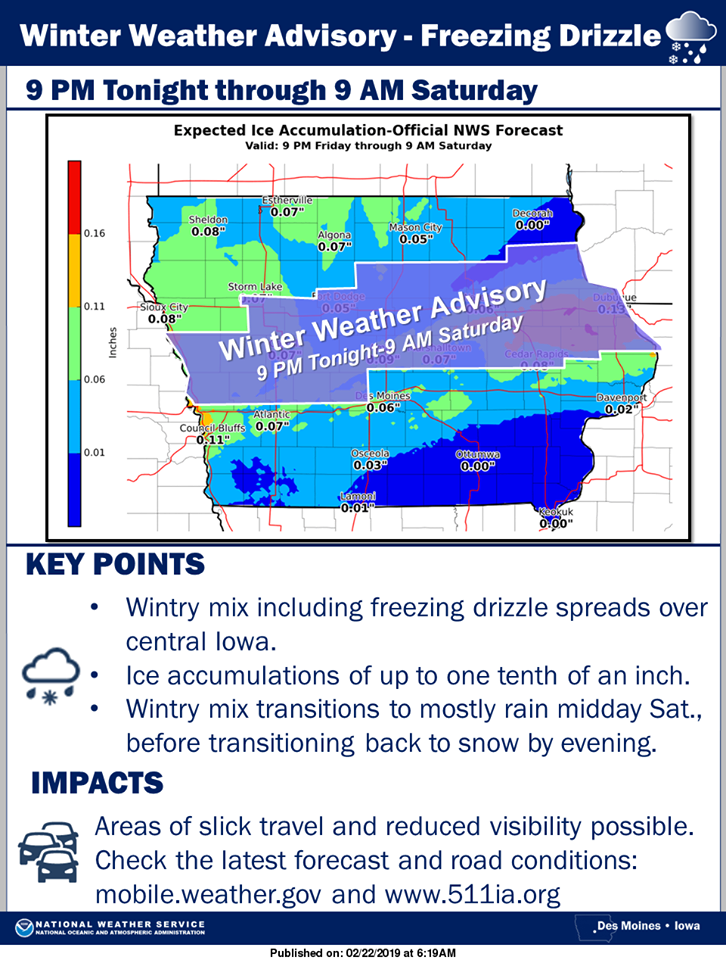
(Radio Iowa) — Forecasters say Iowa will get another one-two punch from winter weather this weekend, with the potential for rain, sleet, snow, ice, blizzard conditions and even flooding. Meteorologist Chad Hahn, with the National Weather Service in metro Des Moines, says the first round tonight (Friday) won’t entail much snow, if any, though a layer of ice is threatened. “Expect freezing drizzle to develop across much of the state of Iowa later on this evening and overnight,” Hahn says. “Even some light glazing is possible across portions of the state overnight and that will continue into the morning hours on Saturday.”
Temperatures are predicted to warm up into the upper 30s tomorrow, changing the snow to rain and raising the chances of ice dams, ice jams and flooding. “We’ll have a break as we get into the day on Saturday where we actually transition much of the state into rain but it’ll be pretty short-lived because the colder air will filter in later on Saturday afternoon and especially overnight on Saturday night,” Hahn says. “We’re expecting significant accumulating snows across the central part of Iowa.”
The heaviest snow is forecast to fall roughly from the Omaha area to Fort Dodge to Mason City. That region may see six to eight inches of snow. As the storm front moves through Iowa, there’s the potential for blizzard conditions on Sunday. “Winds are going to increase significantly behind the low pressure area with wind gusts out of the northwest at 40 to 50 miles an hour,” Hahn says. “In areas that do see that snowfall, they can expect significant blowing and drifting as we work into Saturday night and during the day on Sunday.”
A series of winter weather advisories, watches and warnings are being posted through Sunday for wide sections of the state. Visit weather-dot-gov for details. In the long-ranger forecast, Hahn says we may see more snow Monday and Tuesday in what’s already one of the snowiest Iowa February’s on record.
The National Weather Service says “Phase #1 of a very potent storm system will bring a round of freezing drizzle to central and northern Iowa this evening through Saturday morning.” Ice accumulation of up to one tenth of an inch is expected. A Winter Weather Advisory has been issued for the central section of Iowa. This will likely make for difficult travel this evening through Saturday Morning. Please be careful in traveling.
 Here’s a reminder of the current Winter Weather Watches & Advisories…
Monona-Harrison-Shelby-Pottawattamie Counties……WINTER WEATHER ADVISORY IN EFFECT FROM 4 PM TODAY THROUGH NOON SATURDAY…...WINTER STORM WATCH REMAINS IN EFFECT FROM NOON SATURDAY AFTERNOON THROUGH 6-PM SUNDAY…Mixed precipitation.Blizzard conditions possible. Total snow accumulations of up to one inch and ice accumulations of around one tenth of an inch expected. Total snow accumulations of 3 to 6 inches and ice accumulations of a light glaze possible. Winds could gust as high as 45 mph.
Audubon-Guthrie-Dallas Counties…WINTER WEATHER ADVISORY IN EFFECT FROM 9 PM TODAY (FRIDAY) THROUGH 9-A.M. SATURDAY. .WINTER STORM WATCH REMAINS IN EFFECT FROM 6-P.M. SATURDAY THROUGH 6-P.M. SUNDAY. Mixed precipitation expected tonight through Sunday morning. Blizzard conditions possible Saturday evening into Sunday. Ice accumulations of up to one tenth of an inch
possible. Total snow accumulations of 3 to 5 inches possible. Winds could gust as high as 50 mph.
Cass-Adair-Madison-Adams-Union-Taylor-Ringgold Counties….WINTER STORM WATCH REMAINS IN EFFECT FROM 6-PM SATURDAY THROUGH 6-PM SUNDAY…Blizzard conditions possible. Total snow accumulations of 2 to 4 inches possible. Winds could gust as high as 45 mph. Plan on slippery road conditions. Areas of blowing snow could significantly reduce visibility.
Mills-Montgomery-Fremont-Page Counties……WINTER STORM WATCH REMAINS IN EFFECT FROM NOON SATURDAY UNTIL 6-P.M. SUNDAY. Blizzard conditions possible. Total snow accumulations of 2 to 8 inches and ice accumulations of a light glaze possible. Winds could gust as high as 35 to 55 mph. Near zero whiteout conditions.
PRECAUTIONARY/PREPAREDNESS ACTIONS…
A Winter Storm Watch for blizzard conditions means there is a potential for falling and/or blowing snow with strong winds and extremely poor visibilities. This can lead to whiteout conditions and make travel very dangerous. A Winter Weather Advisory means that periods of snow, sleet or freezing rain will cause travel difficulties. Expect slippery roads and limited visibilities, and use caution while driving.
Today: Partly cloudy to cloudy. High 33. E @ 10-15.
Tonight: Cloudy w/light freezing rain/light snow. Low 29. E @ 5-10.
Tomorrow: Cloudy w/mixed precipitation (Light rain/freezing drizzle) in the morning, changing to snow late. High 37 by mid-morning, w/temps dropping during the day. E/NE @ 10-20.
Tomorrow night: **Winter Storm Watch from 6-p.m. Saturday thru 6-p.m. Sunday**Snow before midnight. The snow could be heavy at times. Patchy blowing snow. Low around 17. NW @ 15-30 w/gusts to 45 mph at times. Wind chill values as low as 5. New snow accumulation of 4 to 8 inches possible.
Sunday: Mostly cloudy w/flurries possible early & blowing snow. High 22.
Monday: Mo. Cldy w/a chance of snow in the morning. High 25.
Yesterday’s High in Atlantic was 37. Our Low was -6. Last year on this date our High was 32 and the Low was 22. The record High in Atlantic on this date was 71 in 2017. The Record Low was -14 in 1894.


