
Today: *DENSE FOG ADVISORY until 1-p.m.*WIND ADVISORY 10-a.m. to 7-p.m.*FLOOD WATCH through Thursday evening; Fog this morning, Showers & scattered thunderstorms , some may produce heavy rain. High 58. S @ 15-30.
Tonight: Light rain or drizzle. Low 46. S-W @ 10-20.
Tomorrow: Light rain. High nearly steady in the 40’s. NW @ 15-30.
Friday: P/Cldy. High 41.
Saturday: P/Cldy. High 46.
Yesterday’s High in Atlantic was 45. Our Low was 37. 24-hours rainfall at KJAN (through 7-a.m. today) was .36”. Last year on this date our High was 46 and the Low was 16. The record High in Atlantic on this date was 72 in 2012. The Record Low was -11 in 1948 and 1975.
The National Weather Service has now posted Dense Fog, Wind, and Flood Advisories across the KJAN listening area for the next two days. Here is a look at the rundown of those latest additions to the weather situation in the Nishna Valley.
The National Weather Service in Omaha has issued a
* Flood Advisory for Rapid Rises for Rain and Snowmelt in Mills, Shelby, Monona, Pottawattamie, Montgomery, Fremont, Harrison, and Page Counties in the listening area until 7:45pm on Tuesday.
* At 141 PM CDT, emergency management and storm spotters reported
that snowmelt was causing minor flooding of both rural and urban
roads. This situation will likely become more widespread tonight
into Wednesday as rainfall increases in areal coverage and
intensity. If traveling, be alert to road closures and the
potential for water-covered sections of road. This is especially
the case at night when visibility is reduced.
Audubon-Guthrie-Cass-
…DENSE FOG ADVISORY IN EFFECT FROM 7 PM THIS EVENING TO 7 AM
CDT WEDNESDAY…
…WIND ADVISORY IN EFFECT FROM 10 AM TO 7 PM CDT WEDNESDAY…
Crawford-Carroll-Greene-
…DENSE FOG ADVISORY IN EFFECT FROM 7 PM THIS EVENING TO 7 AM
CDT WEDNESDAY…
Adair-Adams-Union-Taylor-Ringgold
…WIND ADVISORY IN EFFECT FROM 10 AM TO 7 PM CDT WEDNESDAY…
The National Weather Service in Des Moines has issued a Dense Fog
Advisory, which is in effect from 7 PM this evening to 7 AM CDT
Wednesday. A Wind Advisory has also been issued. This Wind
Advisory is in effect from 10 AM to 7 PM CDT Wednesday.
* TIMING…Dense fog advisory tonight, Wind Advisory through the
day Wednesday.
* WINDS…Southeast at 25 to 35 mph gusting to 45 mph Wednesday.
* VISIBILITY…Around 1/4 mile or less tonight.
* IMPACTS…With the recent rain and additional rain expected,
combined with low visibility. Water ponding on roads may be
difficult to see, especially at night. Take it slow when driving,
especially in low-lying areas and in areas of poor drainage.
Gusty winds may make travel difficult for high-profile vehicles
on Wednesday.
1058 AM CDT Tue Mar 12 2019
The National Weather Service in Omaha has issued a flood warning for the following rivers in Iowa:
Do not drive cars through areas where water covers the road. The water depth may be too great to allow your vehicle to pass safely. A Flood Watch is in effect for all of southwest Iowa from Wednesday morning through Thursday evening.
(Updated 4-a.m. 3/12/19) Sac-Crawford-Carroll-Audubon-Guthrie-Dallas-Cass-Adair-Madison-Adams-Union-Taylor-Ringgold Counties...A FLOOD WATCH REMAINS IN EFFECT FROM 7-A.M. WEDNESDAY THROUGH 7-P.M THURSDAY
* Rapid snowmelt and expected rainfall is expected lead to significant rises on rivers and streams and the potential for ice jams.
Monona-Harrison-Shelby-Pottawattamie-Mills-Montgomery-Fremont-
Page Counties…FLOOD WATCH IN EFFECT FROM 1-A.M. WEDNESDAY THROUGH 7-P.M. THURSDAY..
* Warmer temperatures will accompany a strong storm system which will likely produce 1 to 3 inches of rain the next several days. This will heighten the risk of river flooding due to the unusual combination of heavy rain, snowmelt, frozen ground, and thick ice cover on area rivers.
* ADDITIONAL DETAILS…Significant and rapid river level increases are possible due to excessive runoff. Ice jams could also develop which would further enhance the flood threat.
PRECAUTIONARY/PREPAREDNESS ACTIONS…
A Flood Watch means there is a potential for flooding based on current forecasts.
You should monitor later forecasts and be alert for possible Flood Warnings. Those living in areas prone to flooding should be prepared to take quick action should flooding develop.
Today: Mostly cloudy w/light rain. High 45. SE @ 15-25.
Tonight: Cloudy w/rain. Low 43. S @ 10-20.
Tomorrow:**FLOOD WATCH from 7-a.m. Wed. through 7-a.m. Thu.** P/Cldy to Cldy w/showers & scattered thunderstorms. High 58. S @ 15-30.
Thursday: Mo. Cldy with light rain. High 42.
Friday: P/Cldy. High 40.
Yesterday’s High in Atlantic was 43. Our Low was 21. Last year on this date our High was 49 and the Low was 21. The record High in Atlantic on this date was 74 in 1938. The Record Low was -21 in 1998.
The National Weather Service has now expanded the Flood Watch region to include the entire KJAN listening area later this week. depending on your exact location the watch will go into effect Tuesday night or Wednesday morning and continue into Thursday night.
From Wednesday morning through Thursday evening
* Rapid snowmelt and expected rainfall will lead to significant
rises on rivers and streams and the possibility of ice jams as
well.
* Favored ice jam locations include the Des Moines River around
Fort Dodge, the Raccoon River around Van Meter through Des
Moines to the confluence of the Des Moines River, and the Iowa
River around Marshalltown. Other locations are possible for ice
jam flooding. Minor to moderate river flooding from snowmelt and
rainfall is possible in some locations.
PRECAUTIONARY/PREPAREDNESS ACTIONS…
A Flood Watch means there is a potential for flooding based on
current forecasts.
You should monitor later forecasts and be alert for possible
Flood Warnings. Those living in areas prone to flooding should be
prepared to take action should flooding develop.
The Adair & Guthrie County Emergency Management Agency will be hosting a Storm Spotter Training Session in the Community Building next to City Hall in Menlo on March 20, 2019 at 7:00 PM. This training session is open to the all county responders and the public. The training session is free.
The session normally last two hours and acquaint you with basic information on the formation of severe weather storms and how they function. What to report, as well as how and where you should communicate the information. After training, you may register as a severe storm spotter on the National Weather Service web site or at spotter training sessions. This would enable meteorologists to call you to get real time information and to confirm severe weather activity indicated by Doppler radar images in your vicinity.
According to Robert Kempf, Emergency Management Coordinator, “One person could make the difference in the potential injuries or deaths from a severe storm or tornado. By being aware of the possibility of severe weather or tornados in your area, you can react to rapidly changing weather conditions and improve you, your family and your community’s safety in such an event. As a trained spotter serving your area and providing the National Weather Service with severe storm reports, meteorologists can correlate your real‑time information of storm activity with the data they are receiving by radar”, according to Robert Kempf, Emergency Management Coordinator.
Why does National Weather Service need severe weather reports from trained weather spotters? The Doppler radar cannot detect what is really happening at ground level, especially the greater the distance the weather event is from the radar site. The radar is designed to look into the heart of storm clouds and their surroundings to detect wind currents and other storm structure clues that suggest a storm is or will become severe. With accurate ground truth reports along with radar images and other meteorological data available to weather service personnel, the decision can be made whether to issue a storm warning to the public.
With timely reports of severe storm activity volunteered by citizens and data from improved technology at the National Weather Service offices, the numbers of injuries and deaths in Iowa from severe weather can be minimized.
Click to enlarge image

Click to enlarge image
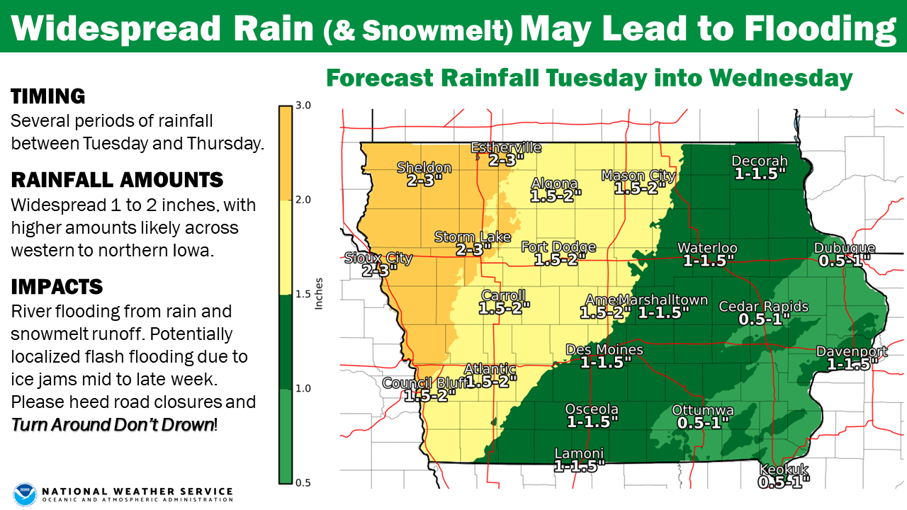
The National Weather Service reports widespread rain across Iowa remains on track for Tuesday through Thursday, where a swath of 1 to 2 inches of rain can be expected. Thunderstorms are possible as well, resulting in locally higher amounts approaching 3 inches, especially over western portions of Iowa. In addition to the rainfall, warmer temperatures will melt a good portion of the snow pack today through Wednesday resulting in significant runoff and potential river flooding mid to late week and into the weekend. The potential for ice jams exist as the runoff, swelling rivers, and warmer temperatures look to break up the river ice and lead to some localized flash flooding.
Monona-Harrison-Shelby-Pottawattamie-Mills-Montgomery-Fremont-Page Counties: A FLOOD WATCH IS IN EFFECT FROM LATE TUESDAY NIGHT/EARLY WED. EVENING THROUGH WEDNESDAY EVENING.
The National Weather Service in Omaha/Valley has issued a Flood Watch for portions of Iowa and Nebraska from 1-a.m. Wednesday through 7-p.m. Wednesday.
* A strong storm will bring warming temperatures and 1 to 3 inches of rain to the region during the middle of the week. This will result in an increased risk of river flooding, do to the unusual
combination of heavy rain, snowmelt, saturated or frozen soils, and thick ice cover on area rivers. Significant and rapid river level increases are possible do to runoff or localized ice jams. Anyone with interests along or near area rivers should continue to monitor the forecast and river levels closely.
PRECAUTIONARY/PREPAREDNESS ACTIONS…
A Flood Watch means there is a potential for flooding based on current forecasts. You should monitor later forecasts and be alert for possible Flood Warnings. Those living in areas prone to flooding should be prepared to take action should flooding devel
Today: Partly Cloudy. High 38. E/SE winds @ 5-10.
Tonight: Cloudy w/scattered light freezing drizzle. Low 31. SE @ 5-10.
Tomorrow: Cldy w/rain. High 41. SE @ 15-25.
Wednesday: P/Cldy to Cldy w/rain & scatt. thunderstorms. High 52.
Thursday: Mo. Cldy w/light rain. High near 40
Yesterday’s High in Atlantic was 37. Our Low was 18. Last year on this date our High was 39 and the Low was 26. The record High in Atlantic on this date was 69 in 1900. The Record Low was -22 in 1948.


