
Today: Mostly cloudy this morning w/drizzle ending; P/Cldy this afternoon. High 56. N @ 10-15.
Tonight: Mostly cloudy w/light rain overnight. Low 44. N @ 5-10.
Tomorrow: Cloudy w/rain ending in the morning; P/Cldy during the afternoon. High 62. N @ 10-15.
Friday: P/Cldy. High 65.
Satuday: P/Cldy. High around 68.
(Radio Iowa) — May is starting out much like April ended, with continued cold weather and rain across much of the region. Meteorologist Dennis Todey, director of the U-S-D-A’s Midwest Climate Hub, based in Ames, says the long-range forecast models well into the middle of May don’t show much change for precipitation or temperatures. “The Northern Plains are not looking really good on either one of those,” Todey says. “In the Week Two time period, we’re likely to have below-average temperatures again, so we’re not making a whole lot of progress on warming up soils and drying things out.”
Some parts of the state have had standing water due to flooding for more than a month and some farmers are far behind in their planting due to soggy soil. Todey says the weather pattern simply isn’t shifting much. “Typically by this point in the spring, we do start getting more storm events, we start getting more warm air moving northward and we are getting some of that,” Todey says. “Unfortunately, it hasn’t moved far enough yet on a more regular basis. We’re still getting these fairly significant cold outbreaks and that has allowed the storm track to be such that we’re going to keep getting continued rainfall.”
For areas of the state that still haven’t had the chance to dry out from the spring soakings, Todey says there’s little relief in the immediate forecast. “It looks like throughout a good part of the Corn Belt area and a chunk of the Northern Plains,” Todey says, “we have above-average chances for precipitation going on well into the middle part of May right now.” Todey expects the effects of the ongoing El Nino pattern to hang around into mid-summer, which could translate into below-normal temperatures and above-normal precipitation.
Today: Mostly cloudy w/rain.. High 55. E/NE @ 10-20.
Tonight: Mostly cloudy w/light rain. Low 43. N @ 10-15 mph.
Tomorrow: Cloudy to P/Cldy. High 58. N @ 10-15.
Thursday: Cloudy to P/Cldy, w/rain in the morning. High 62.
Friday: P/Cldy. High around 65.
Yesterday’s High in Atlantic was 65. We received .01” rain overnight (as of 5-a.m. today). Our Low was 45. Last year on this date our High was 83 and the Low was 59. The record High in Atlantic on this date was 92 in 1926. The Record Low was 19 in 1958.
In an update to our earlier reports, the National Weather Service in Valley, Nebraska, said today (Monday), that the Hancock Weather Transmitter (KZZ-52) will continue to be out of service for anywhere from 12-to 14-weeks, possibly longer, while they wait for repair crews to assess the damage to the Hancock Tower and related components that send out the Emergency Alert System tones your weather radio receives during times of severe weather or other emergencies. The facility was knocked-off the air this past winter due to icing. Officials say the stability of the tower must be assessed before they can look at other critical components. The transmitter covers parts of six area counties and all of Cass County.
That means unless you are signed-up for the Cass County Emergency Notification System, you will have to be extremely weather aware during this severe storm season. Signing-up is free and easy, and you can select the types of alert(s) you want to receive and how you want to receive them (voice, text or e-mail). You can select any or all communities in Cass County for your warning area, as well. And, you can indicate if anyone at your residence has special needs (Such as: Assistive devices, bedridden, blind/vision impaired, Deaf/hearing impaired, limited mobility/wheelchair user, and if the person uses an oxygen machine/cylinder).
To sign-up, go to the Cass County Emergency Management page http://www.atlanticiowa.com/county/county-departments/emergency-management/ and click on the Alert Iowa! link. If you have any questions or need help, call Cass County Emergency Management Coordinator Mike Kennon at 712-254-1500,
Today: Mostly cloudy w/light rain ending this morning; Becoming Partly cloudy. High 62. NW @ 10-20.
Tonight: Mostly cloudy w/light rain redeveloping late. Low 45. E @ 5 mph.
Tomorrow: Cloudy w/rain High 55. E/NE @ 15-25.
Wednesday: P/Cldy to Cldy. High 60.
Thursday: Cldy w/rain. High around 60.
Yesterday’s High in Atlantic was 54. We received .07” rain overnight (as of 5-a.m. today). Our Low was 36. Last year on this date our High was 74 and the Low was 45. The record High in Atlantic on this date was 93 in 1987. The Record Low was 22 in 1958.
Today: Mostly cloudy, with a high near 55. South southeast wind 5 to 15 mph, with gusts as high as 26 mph.
Tonight: A chance of showers and thunderstorms with a low around 44. South southeast wind 6 to 14 mph becoming east northeast after midnight. Winds could gust as high as 24 mph. Chance of precipitation is 70%. New rainfall amounts between a tenth and quarter of an inch, except higher amounts possible in thunderstorms.
Monday: A 30 percent chance of showers before 8am. Cloudy through mid morning, then gradual clearing, with a high near 60. North northwest wind 7 to 14 mph, with gusts as high as 23 mph. New precipitation amounts of less than a tenth of an inch possible.
Monday Night: A 50 percent chance of showers, mainly after 2am. Increasing clouds, with a low around 44. North northwest wind 7 to 10 mph becoming northeast after midnight. New precipitation amounts of less than a tenth of an inch possible.
Tuesday: Showers likely and possibly a thunderstorm before 11am, then showers likely between 11am and 2pm, then showers likely and possibly a thunderstorm after 2pm. Cloudy, with a high near 54. Northeast wind 11 to 15 mph, with gusts as high as 23 mph. Chance of precipitation is 70%. New rainfall amounts between a quarter and half of an inch possible.
Tuesday Night: Showers and thunderstorms likely before 11pm, then a chance of showers. Cloudy, with a low around 42. Chance of precipitation is 60%.
Wednesday: A 20 percent chance of showers before 8am. Mostly cloudy, with a high near 59.
(Radio Iowa) — While it was slow to develop, it appears the effects of the current El Nino weather pattern will hang around the region for a while — likely several months. Meteorologist Dennis Todey, director of the U-S-D-A’s Midwest Climate Hub, based in Ames, says they expect a longer-than-average El Nino, which typically means warmer, wetter weather for Iowa. “March, April, May, all the way to June, July, August and September,” Todey says. “The probability of El Nino is the highest staying above 60% most of the way through the summer, so, we’re expecting that to be with us.”
An El Nino occurs when Pacific Ocean surface temperatures rise, which in turn impacts weather across North America. An El Nino can last just nine to 12 months or sometimes as long as seven years. Todey says the center is predicting warmer-than-normal temperatures at least through early summer. “The chances for May temperatures lean slightly towards the warm side over most of the eastern part of our region,” Todey says. “Parts of Kansas and Colorado have a slightly increased chance of below-average temperatures and the warm extends through the Northern Plains. None of these probabilities are very high, a little bit in the eastern part of the Corn Belt.”
Todey says the long-range outlooks calls for above-normal rainfall for most of the summer. “It is an interesting contrast when we look at the precipitation probabilities,” he says. “This is a 50% chance of above-average precipitation. That’s fairly high and this whole area is actually fairly high, given we’re in a May-to-July, more convective time of season. It’s not often you see this from the climate prediction center.” It follows a snowy winter and a rainy early spring which led to record flooding on the Missouri River and significant flooding on the Mississippi and elsewhere, with billions of dollars damage in Iowa and several neighboring states.
The National Weather Service says thunderstorms are likely across much of Iowa on Wednesday and into early Wednesday night. There will be a threat of severe weather with some of the storms, especially from late in the day through the evening. Large hail and damaging winds will be the primary threats, but there is a possibility of isolated tornadoes as well. The primary threat seems to have shifted further east (Des Moines and southeast/southern Iowa), but the risk of severe weather in the KJAN listening area cannot be ruled out.
Now is a good time to review your severe weather plan, and be sure to monitor the latest forecast updates leading up to Wednesday!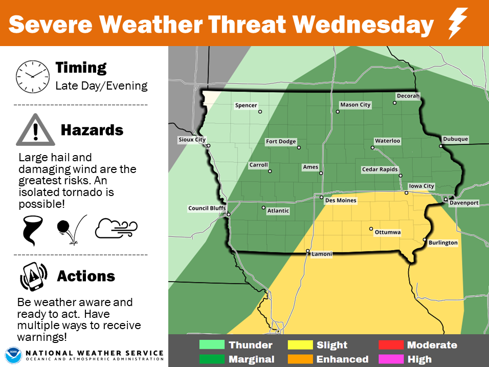
Today: Partly-to-Mostly sunny. High around 68. S winds @ 10-15 w/gusts to near 25.
Tonight: Partly cloudy, with a low around 45. SE @ 10-15 becoming calm after midnight.
Tomorrow: Partly cloudy. High near 70. SE @ 10-15 mph.
Tom. night: Mostly cloudy w/a 40% chance of showers and thunderstorms. Low around 56.
Wednesday: Mo. Cldy w/a 50% chance of showers and thunderstorms. High near 70.
Thursday: Cloudy w/rain likely, especially in the morning. High near 55.
Yesterday’s High in Atlantic was 54. Our 24-hour Low (Ending at 7-a.m.) was 29. Last year on this date our High was 31 and the Low was 20. The record High in Atlantic on this date was 84 in 1920. The Record Low was 17 in 1926 & 1962.


