OMAHA, Neb. (AP) — Areas around Lincoln, Omaha, Bellevue and other cities in eastern Nebraska are under a flash flood warning after torrential rains early Tuesday. The National Weather Service has issued the warning for parts of Lancaster, Douglas, Sarpy, Saunders and Washington counties. The alert also covers a western portion of Pottawattamie County, including Council Bluffs, across the Missouri River in Iowa.
The weather service says up to 2 inches of rain had fallen on those areas overnight — most of it since 4 a.m. Tuesday. Several low-lying traffic lanes in midtown and downtown Omaha were covered with water before 5 a.m. The weather service says flooding in those areas could worsen, as more rain is expected in the region throughout the day.
Today: **FLASH FLOOD WATCH until 7-a.m. Wednesday.**Mo. Cldy w/showers & thunderstorms. Some may be severe & with heavy rain. High near 70.E @ 10-15.
Tonight: P/Cldy to Cloudy w/showers & thunderstorms. Some may be severe. Heavy rain possible. Low 58. E @ 5-10.
Tomorrow: P/Cldy to cldy w/scattered shwrs & tstrms. High 78. SE @ 10-15.
Thursday: P/Cldy w/isolated showers & tstrms. High around 76.
Friday: P/Cldy. High around 80.
Yesterday’s High in Atlantic was 79. Our Low this morning 52. Rainfall in Atlantic as of 7-a.m.= 1.78″ (24-hour total) Last year on this date our High was 97 and the Low was 66. The record High in Atlantic on this date was 97 in 2018. The Record Low was 29 in 1894.
345 AM CDT Tue May 28 2019…Area Counties: Audubon-Guthrie-Dallas-Cass-Adair-Madison…FLASH FLOOD WATCH IN EFFECT FROM 1 PM CDT THIS AFTERNOON THROUGH 7-A.M. WEDNESDAY…
Area Counties: Adams-Union-Taylor-Ringgold..FLASH FLOOD WATCH IN EFFECT NOW THROUGH 7-A.M. WEDNESDAY.
Pottawattamie-Mills-Montgomery-Fremont-Page Counties: FLASH FLOOD WATCH IN EFFECT FROM 4-A.M. TODAY UNTIL 7-A.M. WEDNESDAY.
The National Weather Service in Des Moines has issued a Flash Flood Watch for portions of south central Iowa, southeast Iowa, and southwest Iowa, Through Wednesday morning
* Multiple rounds of thunderstorms and locally heavy rain could produce potentially significant flash flooding today through tonight.
* Rapid rises on streams, inundation of low lying areas and roads, and dangerous impacts to travel are all possible through tonight.
PRECAUTIONARY/PREPAREDNESS ACTIONS…
A Flash Flood Watch means that conditions may develop that lead to flash flooding. Flash flooding is a VERY DANGEROUS SITUATION. You should monitor later forecasts and be prepared to take action should Flash Flood Warnings be issued.
Today: **FLASH FLOOD WATCH until 10-a.m.**Mo. Cldy w/showers & thunderstorms this morning. Some may be severe. Partly cloudy this afternoon. High near 80. S @ 10-20.
Tonight: P/Cldy to Cloudy w/showers & thunderstorms. Low 60. N @ 5-10.
Tomorrow: P/Cldy to cldy w/scattered shwrs & tstrms. High 72. E @ 10-15.
Wednesday: Mo. Cldy w/scattered showers & tstrms. High around 80.
Thursday: Mo. Cldy w/scattered shwrs. High 77.
Yesterday’s High in Atlantic was 79. Our Low was 57. We received .31″ rain overnight thru 6-a.m. today (Monday). Last year on this date our High was 100 and the Low was 61. The record High in Atlantic on this date was 100 in 2018. The Record Low was 31 in 1907.
The National Weather Service reports strong to severe storms are looking increasingly possible both Monday afternoon/evening and Tuesday afternoon/evening. For both days, all modes of severe weather appear to be possible- including tornadoes, large hail, damaging winds, along heavy rainfall that may lead to flash flooding concerns.
In particular, at this time, Tuesday’s severe weather may be significant. There may be supercells that spawn tornadoes and very large hail. Please monitor the weather forecasts closely, especially if you have outdoor plans Monday afternoon-evening and/or Tuesday afternoon-evening.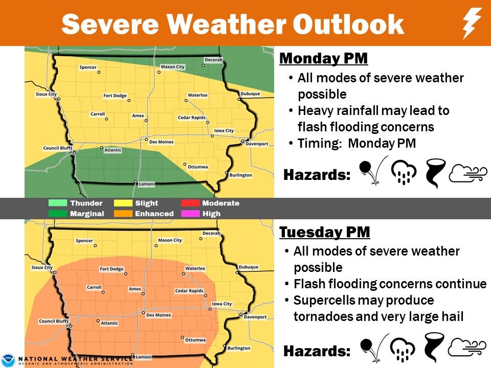
Today: A 20 percent chance of showers and thunderstorms before 7am. Partly sunny, with a high near 78. Northeast wind around 8 mph becoming east southeast in the afternoon.
Tonight: Showers and thunderstorms, mainly after 11pm. Low around 63. East southeast wind 8 to 11 mph, with gusts as high as 18 mph. Chance of precipitation is 100%. New rainfall amounts between a half and three quarters of an inch possible.
Memorial Day: Showers and thunderstorms, mainly before 1pm. High near 80. Breezy, with a southeast wind 13 to 16 mph becoming south southwest in the afternoon. Winds could gust as high as 28 mph. Chance of precipitation is 80%. New rainfall amounts between a quarter and half of an inch possible.
Monday Night: A 50 percent chance of showers and thunderstorms. Mostly cloudy, with a low around 63. South wind 7 to 10 mph. New rainfall amounts between a tenth and quarter of an inch, except higher amounts possible in thunderstorms.
Tuesday: Showers and thunderstorms likely, mainly after 1pm. Mostly cloudy, with a high near 79. South wind 9 to 14 mph, with gusts as high as 21 mph. Chance of precipitation is 60%. New rainfall amounts between a quarter and half of an inch possible.
Tuesday Night: A 50 percent chance of showers and thunderstorms, mainly before 1am. Mostly cloudy, with a low around 57. New rainfall amounts between a tenth and quarter of an inch, except higher amounts possible in thunderstorms.
Wednesday: A 30 percent chance of showers and thunderstorms after 1pm. Partly sunny, with a high near 70.
Yesterday’s High in Atlantic was 81. Our Low was 57. As of 6-a.m. Today, we had received .28” of rain here at KJAN. Last year on this date our High was 100 and the Low was 61. The record High in Atlantic on this date was 100 in 2018. The Record Low was 30 in 1901.
Skyscan Forecast Saturday, May 25, 2019 Dan Hicks
Today: Patchy fog early then partly cloudy to cloudy. A few scattered showers and thunderstorms in the afternoon. SW-NW @ 10-15. High 78.
Tonight: Mostly cloudy. Scattered showers and thunderstorms. Variable winds around 5. Low 61.
Sunday: Partly cloudy to cloudy. Scattered showers and thunderstorms early and then again later in the day. SE @ 10. High 78.
Memorial Day: Mostly cloudy in the morning with showers and thunderstorms. Partly cloudy in the afternoon. High 80.
Tuesday: Mostly cloudy. Scattered showers and thunderstorms. High 77.
The National Weather Service, Friday night, cancelled a Flash Flood Watch that had been in effect until 7-a.m. Saturday, for parts of southwest Iowa. A Flood Warning is in effect for Page County, until early Sunday afternoon.
The forecast flooding has changed from Minor to Record severity for the Nodaway River At Clarinda affecting Page County.
PRECAUTIONARY/PREPAREDNESS ACTIONS…
Do not drive cars through areas where water covers the road. The water depth may be too great to allow your vehicle to pass safely. Turn around…don`t drown!
* At 8:00 PM Friday the flood stage was 26.7 feet…or 3.7 feet above flood stage.
* Flood stage is 23.0 feet.
* Record flooding is occurring and Record flooding is forecast.
* Forecast…the river will continue rising to near 27.1 feet by midnight Friday. The river will fall below flood stage tomorrow (Saturday) evening.
A Flood Advisory remains in effect for the Missouri River affecting Harrison, Pottawattamie, Mills, Montgomery, Fremont and Page Counties through Sunday morning.
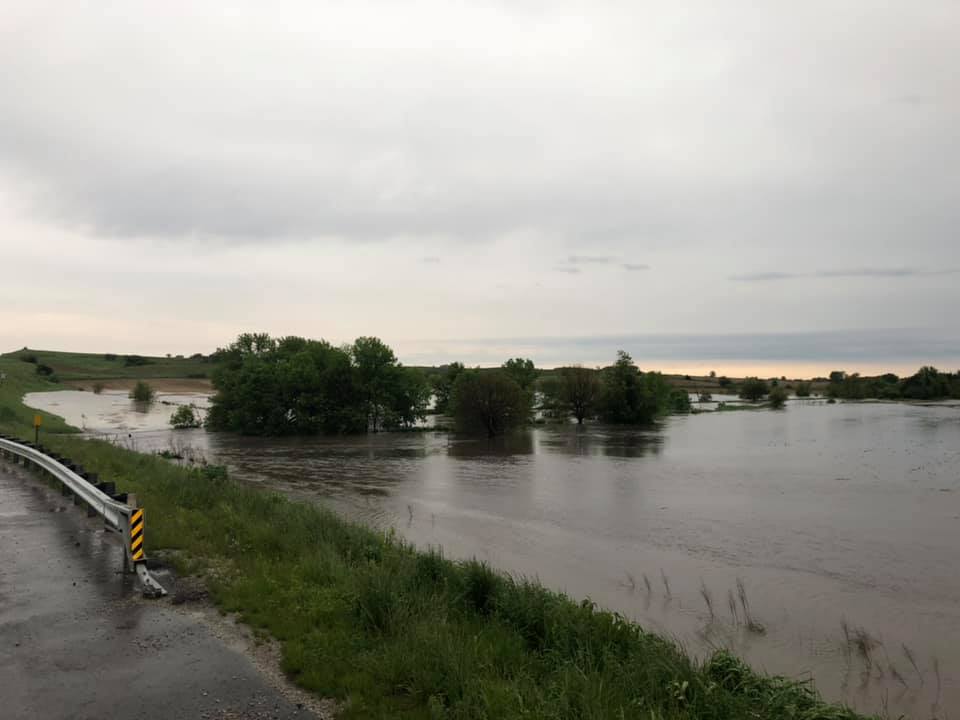
The Montgomery County Emergency Management Agency reports heavy rain fell overnight as well as strong storms through the area. Rivers, streams and creeks are running full. Emergency Management Coordinator Brian Hamman advises residents to please be cautious if traveling. He says Nature Ave between Highway 34 and 220th St., west of Stanton has water over the roadway so please avoid the area. If you encounter flooded roadways TURN AROUND, DON’T DROWN!
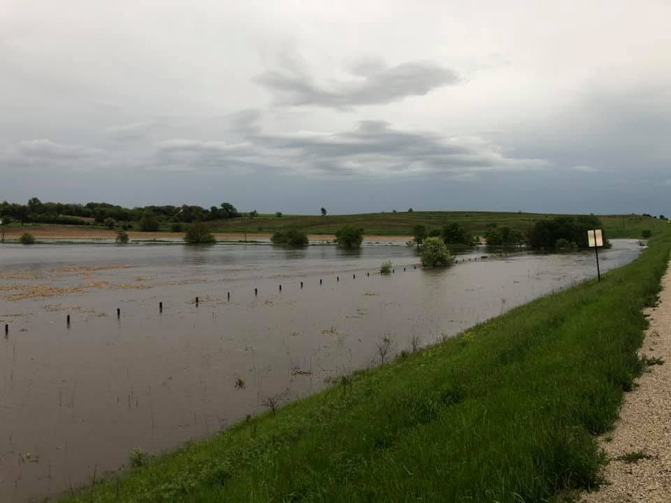
Images from the Montgomery County Emergency Mgmt. Agy. Facebook page