
Warmer temperatures combined with strong winds and dry conditions lead to more brush and wild-land fires across the state. These types of fires can pose a serious threat to lives and property. The National Fire protection Association (NFPA) has reported over 59 million acres have been burned by wildfires in the past decade. While Iowa is not known to have large wildfires like those that regularly affect western states, our state is still prone to dangerous brush fires created by dry conditions, strong winds and low humidity.
To prevent the spread of brush fires and other debris, the Iowa Fire Marshal’s Office suggests keeping in mind:
Check for county burn bans, city restrictions and with the Department of Natural Resources (DNR) Air Quality before conducting any open burning; Never burn on dry and windy days; Have water and tools on hand to extinguish anything that may escape the burn area; Do NOT burn alone, always have another person with you; Do NOT leave a fire unattended; Call 911 immediately if a fire does get out of hand.
And, if you have questions about outdoor fire safety, contact the Iowa Department of Public Safety – State Fire Marshal Division at (515) 725-6145 or e-mail at fminfo@dps.state.ia.us.
COUNTIES: SAC-CRAWFORD-CARROLL-AUDUBON-GUTHRIE-DALLAS-CASS-ADAIR-MADISON-ADAMS-UNION-TAYLOR-RINGGOLD-
1212 PM CDT FRI APR 11 2014
…ELEVATED FIRE DANGER THIS AFTERNOON…
VERY DRY CONDITIONS PREVAIL ACROSS THE AREA AGAIN THIS AFTERNOON…WITH RELATIVE HUMIDITY FALLING TO 15 TO 25 PERCENT IN MANY AREAS. COMBINED WITH GENERALLY WESTERLY WINDS OF AROUND 15 MPH AND GUSTY THIS WILL LEAD TO AN ELEVATED FIRE DANGER UNTIL WINDS SUBSIDE THIS EVENING. ANY OUTDOOR FIRES WILL HAVE THE POTENTIAL TO SPREAD RAPIDLY AND BURNING IS DISCOURAGED.
The (podcast) Freese-Notis weather forecast for the KJAN listening area and weather info. for Atlantic.

Podcast: Play in new window | Download (1.1MB)
Subscribe: RSS
The Iowa Department of Natural Resources reports overall, dry conditions persist for most of Iowa.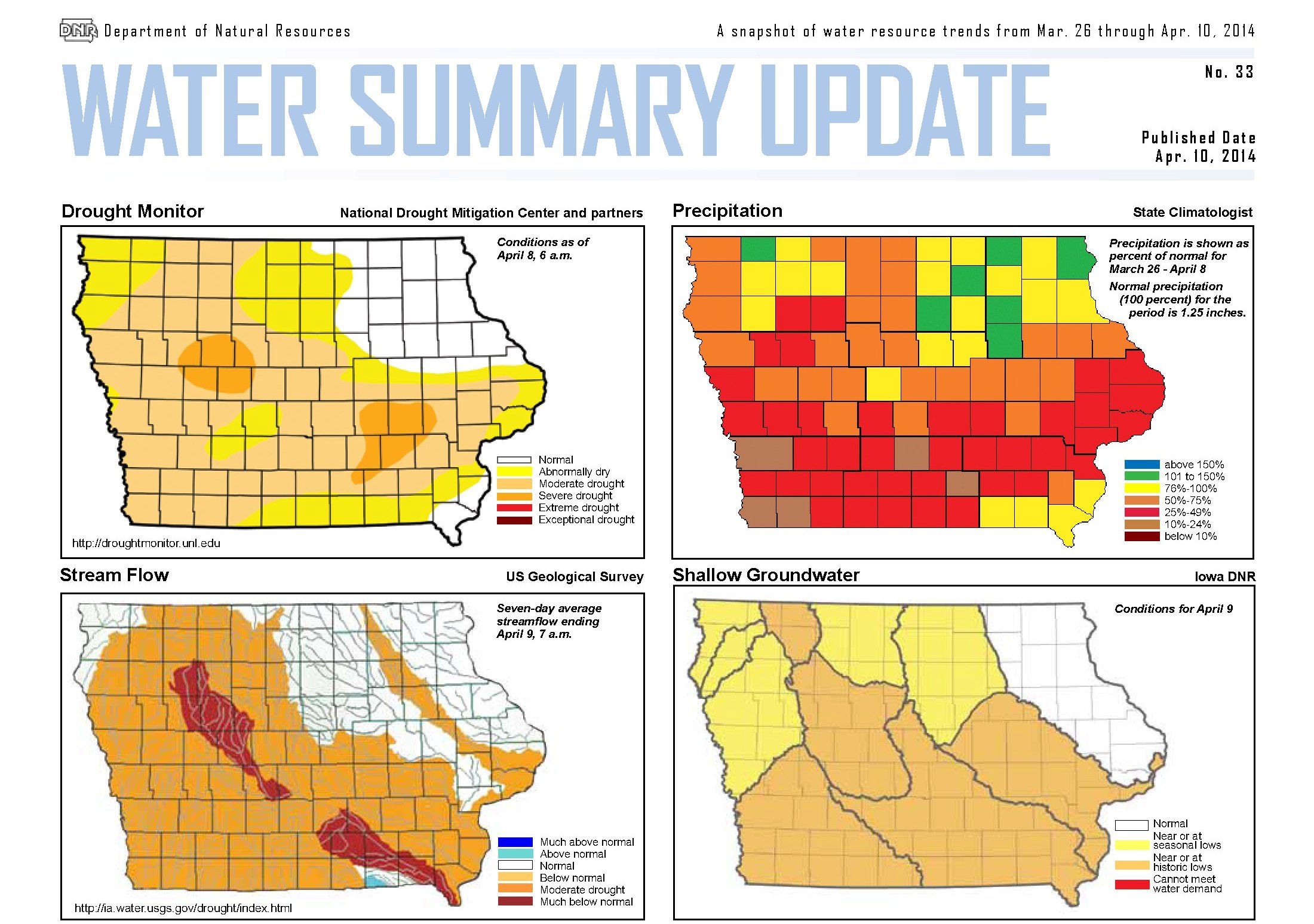 In their latest Water Summary Update, the DNR says precipitation average for the past two weeks has been 0.76 inch — a half inch less than normal. The continuing drought is reflected in the change of stream flows across the majority of the state. The lowest conditions are in the Raccoon and Des Moines river basins, which have less than 10 percent of normal stream flow.
Shallow groundwater levels are lower in southwest, west central and south central Iowa. Adequate spring rainfall will be critical to recharge the alluvial and shallow bedrock aquifers. Conditions are close to normal for northeast Iowa, which had near normal rainfall during the past two weeks.
For a more thorough review of Iowa’s water resource trends March 27 through April 9, go to http://www.iowadnr.gov/watersummaryupdate.
AREA COUNTIES: SAC-CRAWFORD-CARROLL-AUDUBON-GUTHRIE-DALLAS-CASS-ADAIR-MADISON-ADAMS-UNION-TAYLOR
1049 AM CDT THU APR 10 2014
…ELEVATED FIRE DANGER ACROSS MUCH OF CENTRAL IOWA TODAY…
NORTHWEST WINDS WILL INCREASE FURTHER AND BECOME GUSTY BY THIS
AFTERNOON…ALONG WITH RELATIVE HUMIDITY FALLING INTO THE 20S.
THIS COMBINATION OF WIND AND LOW RELATIVE HUMIDITY WILL PRODUCE
AN ELEVATED FIRE DANGER TODAY. THE MOST FAVORABLE CONDITIONS WILL
EXIST DURING THE AFTERNOON. WINDS WILL DIE OFF QUICKLY THIS
EVENING WITH RAPIDLY IMPROVING FIRE CONDITIONS.
The (podcast) Freese-Notis KJAN listening area forecast and weather info. for Atlantic, from KJAN New Director Ric Hanson.
Podcast: Play in new window | Download (1.1MB)
Subscribe: RSS
346 AM CDT THU APR 10 2014
EARLY THIS MORNING…PARTLY CLOUDY. WARMER. SOUTHWEST WIND 10 TO 15 MPH.
TODAY…PARTLY SUNNY UNTIL LATE AFTERNOON THEN CLEARING. BREEZY…COOLER. HIGH IN THE MID 60S. NORTH WIND 15 TO 20 MPH WITH GUSTS TO AROUND 30 MPH.
TONIGHT…PARTLY CLOUDY UNTIL EARLY MORNING THEN BECOMING MOSTLY CLOUDY. LOW IN THE LOWER 40S. WEST WIND NEAR 5 MPH SHIFTING TO THE SOUTH AFTER MIDNIGHT.
FRIDAY…MOSTLY SUNNY. HIGH IN THE LOWER 70S. SOUTHWEST WIND 5 TO 15 MPH.
FRIDAY NIGHT…PARTLY CLOUDY. LOW IN THE UPPER 40S. SOUTH WIND 10 TO 15 MPH.
SATURDAY…MOSTLY CLOUDY. A CHANCE OF THUNDERSTORMS IN THE MORNING…THEN THUNDERSTORMS LIKELY IN THE AFTERNOON. BREEZY. HIGH IN THE MID 70S. SOUTHWEST WIND 15 TO 20 MPH WITH GUSTS TO AROUND 30 MPH. CHANCE OF THUNDERSTORMS 70 PERCENT.
SATURDAY NIGHT…THUNDERSTORMS LIKELY. LOW IN THE UPPER 40S. CHANCE OF THUNDERSTORMS 70 PERCENT.
SUNDAY…RAIN LIKELY. BREEZY. MUCH COOLER. HIGH IN THE UPPER 40S. CHANCE OF RAIN 70 PERCENT.
Officials with the Shelby County Emergency Management Agency have moved the county’s “Fire Danger” Index to “HIGH” until further notice. Dry and windy weather conditions prompted the change. All open burning is prohibited in Shelby County until the danger of rapidly spreading grass and field fires is reduced.
The (podcast) Freese-Notis weather forecast for the KJAN listening area and weather information for Atlantic.
Podcast: Play in new window | Download (1.2MB)
Subscribe: RSS


