
HARSH WIND CHILLS WILL CONTINUE THROUGH AT LEAST THURSDAY MORNING…
BITTER COLD TEMPERATURES DRIVEN BY PLAINS ARCTIC HIGH PRESSURE WILL REMAIN IN PLACE THROUGH THURSDAY MORNING. WINDS WILL REMAIN BRISK TODAY BUT WILL BE DIMINISHING A BIT TOWARDS SUNSET. THE WIND WILL AGAIN INCREASE TONIGHT RESULTING IN PROLONGED DANGEROUS WIND CHILLS HOWEVER TEMPERATURES WILL BE WARMING SOME SO WIND CHILLS WILL LIKELY NOT BE AS COLD AS LAST NIGHT AND THIS MORNING.
SAC-CRAWFORD-CARROLL-AUDUBON-GUTHRIE-DALLAS-CASS-ADAIR-MADISON-UNION COUNTIES…
A WIND CHILL ADVISORY REMAINS IN EFFECT UNTIL 6 AM CST THURSDAY…
* WINDS…A NORTHWEST WIND AT 20 TO 35 MPH WILL DIMINISH SOME TOWARDS SUNSET BEFORE INCREASING AGAIN TONIGHT. THE WIND TONIGHT WILL BECOME SOUTHWEST. AREAS OF BLOWING SNOW TODAY WILL REDUCE VISIBILITY TO ONE MILE OR LESS AT TIMES…ESPECIALLY IN OPEN AREAS.
* TEMPERATURES/WIND CHILL VALUES…TEMPERATURES WILL REACH INTO THE SINGLE DIGITS EITHER SIDE OF ZERO THIS AFTERNOON. LOWS ARE EXPECTED TO FALL BELOW ZERO TONIGHT AND RANGE FROM 7 BELOW TO 14 BELOW ZERO. WIND CHILLS WILL REBOUND TO THE TEENS AND 20S BELOW ZERO LATER IN THE DAY THEN FALL TONIGHT TO 20 BELOW TO 30 BELOW ZERO.
* IMPACTS…FROST BITE CAN LEAD TO HYPOTHERMIA IF PRECAUTIONS ARE NOT TAKEN.
PRECAUTIONARY/PREPAREDNESS ACTIONS…
A WIND CHILL WARNING MEANS THE COMBINATION OF VERY COLD AIR AND STRONG WINDS WILL CREATE DANGEROUSLY LOW WIND CHILL VALUES. IF YOU MUST VENTURE OUTDOORS…MAKE SURE YOU WEAR A HAT AND GLOVES WITH SEVERAL LAYERS OF CLOTHING MINIMIZING EXPOSED SKIN AS MUCH AS POSSIBLE.
The Freese-Notis weather forecast for the KJAN listening area, the latest Winter weather statements, and weather data for Atlantic.
Podcast: Play in new window | Download (1.6MB)
Subscribe: RSS
SAC-CRAWFORD-CARROLL-AUDUBON-GUTHRIE-DALLAS-CASS-ADAIR-MADISON-UNION COUNTIES…418 AM CST WED JAN 7 2015 …
WIND CHILL WARNING REMAINS IN EFFECT UNTIL NOON TODAY… …AND A WIND CHILL ADVISORY WILL IN EFFECT FROM NOON TODAY TO 6 AM CST THURSDAY…
* WINDS...NORTHWEST WINDS WILL GUST TO 25 TO 35 MPH THIS MORNING BEFORE DIMINISHING SOMEWHAT INTO SUNSET. WINDS WILL INCREASE ONCE AGAIN TONIGHT HOWEVER…TURNING TO THE SOUTH SOUTHWEST.
* TEMPERATURES/WIND CHILL VALUES…TEMPERATURES WILL REBOUND LITTLE TODAY REACHING NO BETTER THAN SEVERAL DEGREES EITHER SIDE OF ZERO BY AFTERNOON. WIDESPREAD LOWS BELOW ZERO ARE THEN ANTICIPATED AGAIN TONIGHT…FROM 7 BELOW TO 14 BELOW ZERO. WIND CHILLS WILL BOTTOM OUT AT 25 TO 35 BELOW ZERO BY 6AM TO 8AM BEFORE GRADUALLY REBOUNDING TO THE TEENS AND 20S BELOW ZERO LATER IN THE DAY. THEY WILL FALL AGAIN TONIGHT HOWEVER WITH WIDESPREAD READINGS FROM 20 BELOW TO 30 BELOW ZERO.
* IMPACTS…FROST BITE CAN LEAD TO HYPOTHERMIA IF PRECAUTIONS ARE NOT TAKEN.
WIND CHILL WARNING UNTIL NOON FOR CASS & AREA COUNTIES north east & southeast; WIND CHILL ADVISORY IN EFFECT UNTIL NOON for counties west/sw/& south of Cass County.
Today: Sunny and cold, with a steady temperature around -1. Wind chill values as low as -25. Blustery, with a north northwest wind 15 to 20 mph decreasing to 9 to 14 mph in the afternoon. Winds could gust as high as 29 mph.
Tonight: Partly cloudy, with a temperature rising to around 1 by 4am. Wind chill values as low as -25. Breezy, with a west southwest wind 5 to 10 mph becoming south 12 to 17 mph after midnight. Winds could gust as high as 28 mph.
Thursday: Mostly cloudy, with a high near 21. Wind chill values as low as -20. Windy, with a south wind 18 to 26 mph becoming northwest in the afternoon. Winds could gust as high as 39 mph.
Thursday Night: Mostly cloudy, then gradually becoming mostly clear, with a low around 0. Wind chill values as low as -20. Windy, with a northwest wind 20 to 25 mph, with gusts as high as 39 mph.
Friday: Sunny and cold, with a high near 8. Blustery, with a west northwest wind 13 to 20 mph, with gusts as high as 28 mph.
Friday Night: Clear, with a low around -5.
Saturday: Mostly sunny, with a high near 23.
MONONA-HARRISON-SHELBY-SAC-CRAWFORD-CARROLL-AUDUBON-GUTHRIE-DALLAS-CASS-ADAIR-MADISON-UNION COUNTIES.…317 AM CST WED JAN 7 2015
A WIND CHILL WARNING REMAINS IN EFFECT UNTIL NOON TODAY.
* WINDS…STRONG NORTHWEST WINDS OF 20 TO 35 MPH WITH GUSTS TO 40 MPH.
* WIND CHILL VALUES…TEMPERATURES WILL PLUMMET TO 5 TO 15 BELOW ZERO WITH WIND CHILLS TO 30 TO 40 BELOW ZERO. THE MOST EXTREME CONDITIONS ARE FORECAST FROM 600 AM AND 1000 AM WEDNESDAY MORNING.
* OTHER IMPACTS…THIS WILL RESULT IN FROST BITE AND LEAD TO HYPOTHERMIA OR DEATH IF PRECAUTIONS ARE NOT TAKEN. ESPECIALLY EARLY THIS MORNING!
PRECAUTIONARY/PREPAREDNESS ACTIONS…
A WIND CHILL WARNING MEANS THE COMBINATION OF VERY COLD AIR AND STRONG WINDS WILL CREATE DANGEROUSLY LOW WIND CHILL VALUES.
POTTAWATTAMIE-MILLS-MONTGOMERY-FREMONT-PAGE-ADAMS-TAYLOR-RINGGOLD COUNTIES… 317 AM CST WED JAN 7 2015
A WIND CHILL ADVISORY REMAINS IN EFFECT UNTIL NOON TODAY (Wednesday)
* WIND CHILL VALUES…THE COLDEST INDICES WILL RANGE ANYWHERE FROM 15 TO 30 BELOW ZERO THIS MORNING.
* OTHER IMPACTS…THIS WILL RESULT IN FROST BITE AND LEAD TO HYPOTHERMIA IF PRECAUTIONS ARE NOT TAKEN.
PRECAUTIONARY/PREPAREDNESS ACTIONS…
A WIND CHILL ADVISORY MEANS THAT VERY COLD AIR AND STRONG WINDS WILL COMBINE TO GENERATE LOW WIND CHILLS. IF YOU MUST VENTURE OUTDOORS…MAKE SURE YOU WEAR A HAT AND GLOVES.
Officials with the Iowa Department of Transportation report the combination of light, blowing snow and cold surface temperatures could result in icy roadways today (Tuesday) due to a phenomenon called wheel-track glazing. “Wheel-track glazing” is caused by warm tires trapping the ground-level light, blowing snow. As more vehicles travel over the same wheel tracks, a glaze of ice forms that becomes very slippery. The condition is very difficult for Iowa Department of Transportation crews to treat because the ice is continuously forming on heavily traveled roadways.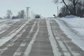
Saving lives and preventing the risk of serious injury under these conditions requires: A basic understanding of the conditions that contribute to wheel-track glazing; Access to current road weather information; The exercising of good judgment; and adherence to simple safety tips.
See the Iowa DOT’s website www.iowadot.gov/maintenance/wheeltrackglazing.html to learn more about the formation of the roadway glaze and its consequences.
For drivers, the consequences of wheel-track glazing can be serious. Stopping distances are 10 times greater than on dry pavement and double that of packed snow. Here are some tips for driving on icy roads, when travel is necessary….
Postpone your trip if possible; On “Ice and Snow … Take It Slow.”; Give you full attention to the driving task. Do not use a mobile communication device while driving; Turn off the vehicle’s cruise control.
Put a safe distance between your vehicle and others sharing the roadway; Keep your windshield clear of snow and ice; Turn on your vehicle’s lights; Allow extra travel time; and if you are starting to skid, tap the breaks. Do not push down and hold the brake pedal.
To discover all the ways in which you can receive around-the-clock Iowa traveler information, visit 511ia.org.
The Freese-Notis weather forecast for the KJAN listening area, the latest Winter weather statements, and weather data for Atlantic.
Podcast: Play in new window | Download (1.4MB)
Subscribe: RSS
AREA COUNTIES: ADAMS-TAYLOR-RINGGOLD–
A WIND CHILL ADVISORY WILL BE IN EFFECT FROM MIDNIGHT TONIGHT TO NOON WEDNESDAY: THE NATIONAL WEATHER SERVICE IN DES MOINES HAS ISSUED A WIND
CHILL ADVISORY…WHICH IS IN EFFECT FROM MIDNIGHT TONIGHT TO NOON
CST WEDNESDAY.
* WINDS…NORTHWEST WINDS OF 15 TO 25 MPH CAN BE EXPECTED BY EARLY WEDNESDAY MORNING.
* TEMPERATURES/WIND CHILL VALUES…TEMPERATURES IN THE SINGLE DIGITS BELOW ZERO WILL BE COMMON WEDNESDAY MORNING. STRONG NORTHWEST WINDS WILL ALSO DROP WIND CHILLS TO 20 TO 30 BELOW ZERO. THE WORST CONDITIONS WILL OCCUR BETWEEN 600 AM AND 1000
AM.
* IMPACTS…FROST BITE CAN LEAD TO HYPOTHERMIA IF PRECAUTIONS ARE NOT TAKEN.
A WIND CHILL ADVISORY IS IN EFFECT UNTIL NOON TODAY (TUES.) FOR: SAC, CRAWFORD AND CARROLL COUNTIES. THEN A WIND CHILL WARNING WILL BE IN EFFECT FROM MIDNIGHT TUES, THRU NOON WEDNESDAY.
AREA COUNTIES: AUDUBON-GUTHRIE-DALLAS-CASS-ADAIR-MADISON-UNION…
415 AM CST TUE JAN 6 2015
…DANGEROUS COLD AND WIND CHILLS INTO MIDWEEK…
THE SNOW HAS ENDED ACROSS IOWA…BUT SKIES CLEARED AS THE SYSTEM PULLED AWAY AND ALLOWED TEMPERATURES TO PLUMMET ACROSS THE NORTHERN HALF OF THE STATE. WINDS WILL NOT BE TOO BRISK THIS MORNING…BUT SUFFICIENT TO DROP WIND CHILLS TO 20 BELOW OR LESS. THE ARCTIC AIRMASS WILL CHANGE LITTLE INTO WEDNESDAY MORNING BUT
EVEN STRONGER WINDS WILL DROP WIND CHILL INDICES FURTHER…DOWN TO 30 BELOW OR LESS AT TIMES.
WIND CHILL WARNING IN EFFECT FROM MIDNIGHT TONIGHT TO NOON WEDNESDAY.
* WINDS…NORTHWEST WINDS OF 15 TO 25 MPH CAN BE EXPECTED BY EARLY WEDNESDAY MORNING.
* TEMPERATURES/WIND CHILL VALUES…TEMPERATURES IN THE SINGLE DIGITS AND TEENS BELOW ZERO WILL BE COMMON WEDNESDAY MORNING. STRONG NORTHWEST WINDS WILL ALSO DROP WIND CHILLS TO 30 TO 40 BELOW ZERO. THE WORST CONDITIONS WILL OCCUR BETWEEN 600 AM AND 1000 AM.
* IMPACTS…FROST BITE CAN LEAD TO HYPOTHERMIA…OR EVEN DEATH…IF PRECAUTIONS ARE NOT TAKEN.
PRECAUTIONARY/PREPAREDNESS ACTIONS...
A WIND CHILL WARNING MEANS THE COMBINATION OF VERY COLD AIR AND STRONG WINDS WILL CREATE DANGEROUSLY LOW…POTENTIALLY DEADLY…WIND CHILL VALUES. IF YOU MUST VENTURE OUTDOORS…MAKE SURE YOU WEAR A HAT AND GLOVES WITH SEVERAL LAYERS OF CLOTHING MINIMIZING EXPOSED SKIN AS MUCH AS POSSIBLE.


