
Monona-Harrison-Shelby-Pottawattamie Counties…A WINTER WEATHER ADVISORY REMAINS IN EFFECT UNTIL 6 PM TODAY…
Snow and blowing snow. Winds gusting as high as 50 mph will cause whiteout conditions in blowing snow. Additional snow accumulations up to 2 inches are expected.
Sac-Crawford-Carroll-Audubon-Guthrie-Cass Counties…A WINTER WEATHER ADVISORY REMAINS IN EFFECT UNTIL 3 PM TODAY.
Snow expected. Additional snow accumulations of 1 to 3 inches. Winds will become northwest and strengthen later today with areas of blowing snow, especially in the heavier snow squalls.
Plan on slippery road conditions, including during the morning commute on Tuesday. Be prepared for reduced visibilities, down to a mile or less at times.
PRECAUTIONARY/PREPAREDNESS ACTIONS…
A Winter Weather Advisory for snow means periods of snow will cause primarily travel difficulties. Be prepared for snow covered roads and limited visibilities, and use caution while driving.
The latest road conditions for the state you are calling from can be obtained by calling 5 1 1.
Sac-Crawford-Carroll-Audubon-Guthrie-Cass Counties…
204 PM CST Mon Mar 5 2018
WINTER WEATHER ADVISORY IN EFFECT FROM 9 PM THIS EVENING TO 3 PM CST TUESDAY.
* WHAT…Snow expected. Total snow accumulations of 1 to 3 inches are expected. Strong northwest winds will develop overnight into Tuesday with areas of blowing snow, especially in the heavier snow squalls.
Monona-Harrison-Shelby-Pottawattamie Counties...WINTER WEATHER ADVISORY IN EFFECT FROM 9 PM THIS EVENING TO 6 PM CST TUESDAY.
* WHAT…Snow and blowing snow expected. Total snow accumulations of 1 to 2 inches are expected. Gusty northwest winds up to 45 to 55 mph overnight through Tuesday morning.
* ADDITIONAL DETAILS…Plan on slippery road conditions, including during the morning commute on Tuesday. Be prepared for reduced visibilities at times.
PRECAUTIONARY/PREPAREDNESS ACTIONS…
A Winter Weather Advisory for snow means periods of snow will cause primarily travel difficulties. Be prepared for snow covered roads and limited visibilities, and use caution while driving. The latest road conditions for the state you are calling from can
be obtained by calling 5 1 1.
The National Weather Service says Cedar and Knox counties in northeast Nebraska are included in a blizzard warning. Wind gusts of up to 50 mph (80 kph) and 4 to 6 inches (10 to 15 centimeters) of snow overnight Monday into Tuesday will make travel hazardous because of the additional potential for whiteouts. Conditions are expected to be less severe south and east of the two counties, including northwest Iowa.
The service says the blizzard warning remains in effect until 6 p.m. Tuesday.
The National Weather Service in Des Moines reports rain will transition to snow late this afternoon into the evening across northern Iowa. During this time frame, generally 1 to 2 inches of snow is forecast over northern Iowa. With the surface low pressure anticipated to push across Iowa overnight tonight into Tuesday morning, blustery west to northwest winds are likely to develop over western Iowa and spread east throughout the day.
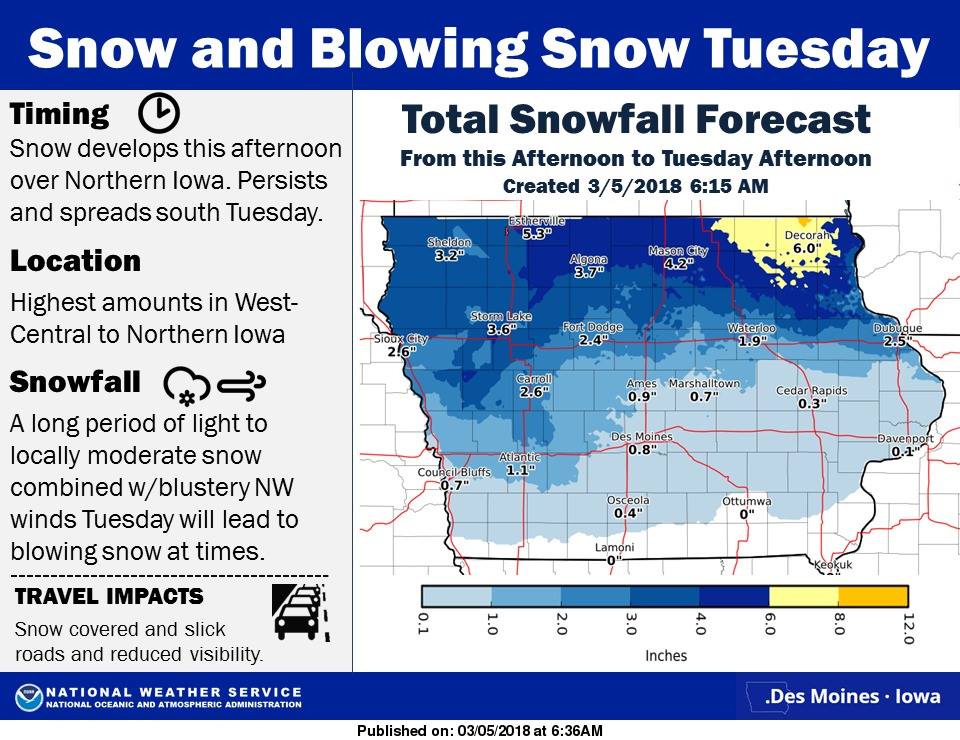 With the falling snow and blustery winds, visibility restrictions can be expected at times during the morning commute Tuesday, especially over western to northern Iowa. Slick roads are possible as well Tuesday. Roughly an additional 1 to 3 inches are possible over western to northern Iowa, with around an inch anticipated over central Iowa.
Today: Rain this morning; Rain-snow this afternoon. High in the 40’s this morning, falling into the 30’s. SE-W @ 15-30.
Tonight: Light snow or flurries. Low 30. W @ 15-30.
Tomorrow: Cloudy w/light snow or flurries. High 36. W-N @ 10-20.
Wednesday: P/Cldy to Cldy. High around 38
Thursday: P/Cldy. High near 40.
Sunday’s High in Atlantic was 61. Our Low this morning (as of 5:20-a.m.) was 43. We received .01″ rain overnight through 6-a.m., here at the KJAN studios. Last year on this date our High was 60 and the Low was 53. The record High in Atlantic on this date was 74 in 1921. The Record Low was -31, in 1960.
Today: Mostly cloudy & Breezy. High around 54. Southeast wind 15-30 mph.
Tonight: Cloudy & breezy with a slight chance of light showers this evening, then a chance of light & thunderstorms overnight. Low around 41. SE @ 15-30.
Monday: Mostly cloudy & windy w/light showers likely along w/a slight chance of thunderstorms. High in the mid 40s. SW wind 15-35mph.
Monday Night: A chance of light rain and snow through midnight, then a chance of light snow after midnight. Patchy blowing snow possible after midnight. Low around 30. W @ 15-30mph.
Tuesday: Cloudy w/patchy blowing snow in the morning. Light snow possibly mixed with rain the rest of the day. High 37. NW @ 15 to 35 mph.
Tuesday Night: Cloudy & breezy. Low in the lower 20’s.
Wednesday: Mostly sunny. High in the mid 30’s.
Thursday: Mostly sunny. High in the upper 30’s.
Saturday’s High in Atlantic was 63. Our Low this morning, 40. Last year on this date, the High in Atlantic was 71 and the Low was 25. The All-time Record High for this date in Atlantic, was 78, in 1921. The Record Low was -17 in 1978.
Skyscan Forecast Saturday, March 3, 2018 Richard Garuckas
Today: Mostly sunny. Breezy. High 60. SSE @ 10-20, gusting to 30mph.
Tonight: Mostly cloudy. Low 45. SSE @ 10-15, gusting to 20mph.
Sunday: Mostly cloudy. Slight chance of showers. High 54. SSE @ 10-20, gusting to 30mph.
Sunday Night: Cloudy. Showers and thunderstorms likely. Low 43.
Monday: Mostly cloudy. Slight chance of morning showers. High 45.
Tuesday: Mostly cloudy. Chance of rain and snow showers. High 37.
Wednesday: Mostly sunny. High 35.

Podcast: Play in new window | Download (747.7KB)
Subscribe: RSS
From Freese-Notis Meteorologist Richard Garuckas…
Today: Mostly sunny & breezy. High 60. S/Se @ 10-20 w/gusts to around 30.
Tonight: Mostly cloudy. Low 45. S/SE @ 10-15, w/gusts to near 20.
Sunday: Mo. Cldy w/a 20% chance of showers. High 54. S/SE @ 15-30.
Sunday night: Cldy w/shwrs & tstrms. Low 43.
Monday: Mo. Cldy w/a 30% chance of morning showers. High 45.
Tuesday: A chance of rain or snow. High 37.
The Iowa Department of Agriculture and Land Stewardship’s State Climatology Office and the National Weather Service are recruiting volunteer precipitation observers across Iowa to participate in the Community Collaborative Rain, Hail and Snow network, known as “CoCoRaHS” (pronounced “KO-ko-rozz”). All that is needed to participate is an interest in the weather, a four inch diameter rain gage, a suitable location to set up the gauge and access to the internet. All data collected are immediately available for free online and are routinely used for flood forecasting, drought assessment, news media stories, scientific research and general weather interest. Weather observers are needed everywhere but the most critical needs (locally) are in Shelby, Adair, and Adams counties.
 Much more information about the network is available on the CoCoRaHS web site at www.cocorahs.org. The website includes information on how to join, where to obtain your rain gauge and how to accurately measure and report rain and snow. There is no cost involved in joining or participating in the CoCoRaHS network other than the need for the four inch diameter rain gauge. State Climatologist Harry Hillaker says “In 2017 Iowa recorded its driest year since the drought of 2012. Severe drought gripped much of south central and southeast Iowa for the second consecutive year where rainfall has been as much as 25 inches less than normal over the past 24 months. Meanwhile, above normal rain amounts were restricted to relatively small areas of northeast and west central Iowa. The past few weeks have seen frequent precipitation with snowfall exceeding two feet at Fort Dodge during February. Whatever comes our way in 2018, the weather observations obtained by this network can be of great benefit in obtaining a clearer picture of Iowa’s weather.”
The CoCoRaHS network was established by the Colorado Climate Center in 1998 and has now spread to all fifty states and Canada. Iowa joined the volunteer network in 2007 and now has over 300 registered CoCoRaHS observers across the state. However, more observers are needed to better document the amount and variability of rain and snow across Iowa.
Atlantic Fire Chief Mark McNees, today (Friday), said in a statement, “Due to the forecast of increasingly high winds in the next few days, we are advising NO BURNING of any type in and around Atlantic, or for that matter, in Cass County. Fire danger conditions will worsen as winds dry out vegetation. Even though it may appear conditions are favorable due to recent precipitation, it will quickly become a greater hazard. Winds will make any type of wildland fire difficult to control and will spread quickly to many areas that are virtually inaccessible due to the wet soil conditions, hampering firefighters gaining access.”
McNees said also, “Burning of trash in burn barrels will also be a risk and is not advised. As always, anyone wishing to burn at anytime is asked to contact their local fire chief for consultation. Several departments are trained to conduct controlled prescribed burns should landowners need to do mid management burns, or simply wish to clear areas of their land.”


