
A warning today from the Shelby County Emergency Management Agency. Operations Officer Jason Wickizer says “We are continuing in the HIGH category however we will be approaching Red Flag Criteria, which are Relative Humidity below 20%, and winds greater than 15MPH. Our current Fire Behavior prediction is 7 foot flame length or greater, Probability of ignition greater than 60%, and Rates of Spread at or greater than 100 yards per minute. We will also be experiencing a wind shift that could cause control issues.”
Wickizer said “Today and tomorrow will not be good days to burn due to Control, and spread issues. Please keep this in mind if people call in asking to burn. The greatest risk today is Spread Potential due to receptive fuels being cured and in line with winds.” Conditions he said, should begin to Moderate Saturday evening.
Warm spring weather has been slow to spread across Iowa and the rest of the Northern Plains, causing costly delays for planting, construction and other outdoor activities. Meteorologist Dennis Todey, director of the U-S-D-A’s Midwest Climate Hub, says changes are underway in the major climate drivers. “We are transitioning between La Nina and potential El Nino, so, a large part of what you’re seeing here is trapped,” Todey says. “There is this noted warming hole over the middle part of the country in the middle part of summer, so that’s what is coming into play here.”
La Nina patterns often bring cooler temperatures along with more storms in some areas and droughts elsewhere. El Nino patterns typically do the opposite. Due to the extended cold weather, many Iowa farmers are a couple of weeks behind in planting and Todey says it will take quite a while to get back to normal growing conditions. “The catching up cannot happen during the early part of the summer,” he says. “Above-average temperatures, middle part of the summer don’t do much to catch us up in the way of growing degree days.”
Todey says there is no single cause for the prolonged winter we’ve seen across much of the region in recent weeks. “There is a little bit of La Nina influence still because we still are in La Nina,” he says, “but there’s not one indicator. There’s a combination of several different things that has locked into it.”
Many areas in the region have set all-time April records for snow and cold temperatures. The Midwest Climate Hub is based in Ames.
(Radio Iowa)
Today: Partly cloudy & breezy. High 72. W-NW @ 10-20.
Tonight: Fair to P/Cldy. Low 35. N @ 10.
Tomorrow: Mostly sunny. High 65. SE @ 10.
Sunday: P/Cldy. High 72.
Monday: A chance of showers in the morning, otherwise P/Cldy. High 79.
Thursday’s High in Atlantic was 72. Our Low this morning (as of 5:45-a.m.) was 30. Last year on this date, the High in Atlantic was 57 and the Low was 36. The Record High for this date in Atlantic was 90, in 1989. The Record Low was 23 in 1950.
Shelby County Emergency Management Coordinator Bob Seivert reports, the local fire Danger will remain HIGH through Monday. If you plan to burn, PLEASE, contact your local Fire Chief. Seivert says they have had several fire dispatches in the last few days where the volunteers are called from home and work to respond to a fire, only to arrive and find someone has started a controlled burn, and not called their local Fire Chief or Emergency Management 911. He asks persons planning a controlled burn, to “Please respect the time our volunteers spend protecting your property. Plan your burn in advance, use a burn plan, and call in prior to starting. 712-755-2124.”
Seivert warns also, that the chances for severe weather are expected to increase next week, so be prepared for weather bulletins and to take cover when warnings are issued.
Today: Partly cloudy to cloudy. High 66. S winds @ 10-15 becoming Northerly.
Tonight: Isolated showers this evening; P/Cldy overnight. Low 40. NW @ 5-10.
Tomorrow: P/Cldy. High near 70. W @ 10-15.
Saturday: Mostly sunny. High 65.
Sunday: P/Cldy. High 74.
Wednesday’s High in Atlantic was 67. We received just a Trace of precipitation after 7-a.m. (The 24-hour gauge reset time). Our Low this morning (as of 6:25-a.m.), was 29. Last year on this date, the High in Atlantic was 45 and the Low was 35. The All-Time Record High in Atlantic on this date was 92 in 1987 and 1989. The Record Low was 15 in 1907.
Today: Mostly cloudy w/light rain this morning; Becoming Partly cloudy. High 64. N @ 10-15mph.
Tonight: P/Cldy. Low 36. Light & variable breeze.
Tomorrow: P/Cldy to Cloudy w/a chance of showers, late. High 66. S winds becoming N @ 10-15.
Friday: P/Cldy. High 66.
Saturday: P/Cldy. High 68.
Tuesday’s High in Atlantic was 77. Our Low was 38. We received .06″ rain overnight at the KJAN studios (as of 5-a.m.). Last year on this date our High was 64 and the Low was 38. The record High in Atlantic on this date was 91 in 2010. The Record Low was 20, in 1934.
Today: Increasing cloudiness w/a chance of showers this evening. High 72. NE @ 10.
Tonight: Mostly cloudy w/light rain. Low 48. NE @ 5-10.
Tomorrow: Showers ending early; Becoming Partly cloudy. High 64. NE @ 10-15.
Thursday: Mo. Cldy w/a chance of showers late. High 66.
Friday: P/Cldy. High 64.
Monday’s High in Atlantic was 75. Our Low was 33. Last year on this date our High was 75 and the Low was 51. The record High in Atlantic on this date was 91 in 1989. The Record Low was 9, in 1956.
Officials with the Shelby County Emergency Management Agency report the danger of fire spreading is getting much greater this week. They ask fire stations and participating businesses to place your Fire Danger notification signs into the HIGH category. Authorities say persons planning a controlled burn to “Plan your burn in advance and talk to your local Fire Chief before you start a fire that may be harder to control than anticipated.”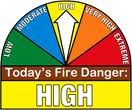
Today: Partly cloudy. High 72. NE @ 10.
Tonight: Fair to P/Cldy. Low 50. Winds light & variable.
Tomorrow: P/Cldy to Cldy w/a chance of afternoon shwrs. High 68. SE @ 10.
Wednesday: Shower possible early, otherwise P/Cldy. High 63.
Thursday: P/Cldy to Cldy w/a chance of afternoon showers. High 68.
Sunday’s High in Atlantic was 70. Our Low this morning (as of 4:55-a.m.) was 34. Last year on this date, the High in Atlantic was 71 and the Low 32. The Record High here, for April 23rd, was 88 in 1950, and the Record Low 19, in 1893.
Today: Partly sunny, with a high near 63. East northeast wind 5 to 10 mph.
Tonight: Partly cloudy, with a low around 39. East northeast wind 5 to 10 mph becoming light northeast.
Monday: Mostly sunny, with a high near 67. Northeast wind 5 to 10 mph.
Monday Night: Partly cloudy, with a low around 43. East northeast wind at around 5mph.
Tuesday: Partly Sunny w/a 20% chance of rain after 1pm. High near 64. N/NE winds becoming N/NW @ 5-10 in the morning.
Tuesday Night: Mostly cloudy w/a 20% chance of rain. Low around 39.
Wednesday: Mostly sunny, with a high near 60.
Wednesday Night: Mostly clear, with a low around 39.
Thursday: Partly sunny & breezy, with a high near 62.
Saturday’s High in Atlantic was 56. Our Low this morning, 44. Last year on this date, the High in Atlantic was 69 and the Low was 31. The Record High for Atlantic on April 22nd, was 90 in 1980. The Record Low was 20, in 1936.


