Record high temperatures were shattered across the Midwest, Tuesday. In Atlantic, we hit 97 degrees at 4-p.m. That broke the old record of 96 set in 1915. State Climatologist Harry Hillaker says readings in portions of northwest and west central Iowa breached 100-degrees Tuesday. The Omaha/Council Bluffs metro area reached 101-degrees for a new record high. Other records broken include Carroll at 102-degrees, Denison and Harlan hit 100-degrees, and Clarinda at 93. Sioux City was at 106-degrees, with Estherville and Spencer both at 103 by mid-afternoon. The record high in Des Moines was set at 3:10-p.m. when the temperature at the Des Moines International Airport hit 94 degrees. The previous record was 93 in 1988.
Hillaker says this is the earliest occurrence of 106 degrees in Iowa since Sac City hit 108 degrees on May 29th, 1934. Historically, there have been 11 years in Iowa since 1873, where temperatures have reached or exceeded 100 degrees in the month of May.1934saw the most days, with 10 dates reaching the century mark. 1934 also saw the highest May reading on record, with 111 degrees at Inwood, set on May 30th.
Conversely, this month also now marks one of the few times that snow has occurred in the same month at 100-degree heat in Iowa. May 1967 saw 8-inches of snow in Glenwood on the third, with temperatures hitting 100 degrees in Onawa on the 24th, and 104 degrees in Sioux Center on the 25th.
In April 1980, snow fell on several different days early in the month, with temps hitting 100 degrees in Fort Dodge and Waterloo on the 22nd.
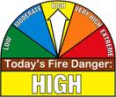
The Shelby County Emergency Management Agency says NO OPENING BURNING is allowed in the County today (Tuesday, May 14th), due to the extremely dry and forecast windy conditions. Officials have bumped the grassland and field fire danger index into the “EXTREME” category for today. The fire danger rating was listed Monday, as “High.”
A Red Flag Warning is in effect for the listening area though late this evening. Officials say Red Flag Warnings are not common in the Midwest, therefore when one is received, the Shelby County Emergency Management Agency will put the Fire Danger index into the Extreme category, and no open burning is permitted.
If you see smoke please report it immediately so fire suppression can take place while the fire is small. For those that find themselves near a fire, explosive fire growth is expected – make sure you are in a safe location and report fires immediately.
The (podcast) weather forecast for the KJAN listening area and weather data for Atlantic…
Podcast: Play in new window | Download (1.2MB)
Subscribe: RSS
**RED FLAG WARNING IN EFFECT (See weather page for details)**
Today: Sunny, with a high near 95. Windy, with a south southwest wind 6 to 11 mph increasing to 18 to 23 mph in the afternoon. Winds could gust as high as 31 mph.
Tonight: A 20 percent chance of showers and thunderstorms after 11pm. Partly cloudy, with a low around 61. Breezy, with a southwest wind 12 to 17 mph becoming light and variable after midnight. Winds could gust as high as 23 mph.
Wednesday: Mostly sunny, with a high near 78. Northeast wind 6 to 11 mph.
Wednesday Night: Mostly cloudy, with a low around 57. East northeast wind 5 to 9 mph.
Thursday: A 30 percent chance of showers and thunderstorms after 1pm. Partly sunny, with a high near 77. East wind 6 to 11 mph. New rainfall amounts of less than a tenth of an inch, except higher amounts possible in thunderstorms.
Thursday Night: A 30 percent chance of showers and thunderstorms. Mostly cloudy, with a low around 62. New rainfall amounts of less than a tenth of an inch, except higher amounts possible in thunderstorms.
Friday: A 30 percent chance of showers and thunderstorms. Partly sunny, with a high near 80.
SAC-CRAWFORD-CARROLL-GREENE-BOONE-AUDUBON-GUTHRIE-DALLAS-CASS-ADAIR-ADAMS-
421 AM CDT TUE MAY 14 2013
…RED FLAG WARNING IN EFFECT FROM NOON TODAY TO 8 PM CDT THIS EVENING…
THE NATIONAL WEATHER SERVICE IN DES MOINES HAS ISSUED A RED FLAG WARNING FOR EXTREME FIRE CONDITIONS…WHICH IS IN EFFECT FROM NOON TODAY TO 8 PM CDT THIS EVENING. THE FIRE WEATHER WATCH IS NO LONGER IN EFFECT. A RED FLAG WARNING MEANS THAT CRITICAL FIRE WEATHER CONDITIONS ARE EITHER OCCURRING NOW…OR WILL SHORTLY. A COMBINATION OF STRONG WINDS…LOW RELATIVE HUMIDITY…AND WARM TEMPERATURES CAN CONTRIBUTE TO EXTREME FIRE BEHAVIOR.
* TIMING…THE RELATIVE HUMIDITY WILL DIP BELOW 25 PERCENT BY NOON AND CONTINUE TO DECREASE DURING THE AFTERNOON. THE LOWEST RELATIVE HUMIDITY AND THE STRONGEST WINDS ARE EXPECTED BETWEEN 1 PM AND 5 PM TODAY. * AFFECTED AREA…WEST CENTRAL TO NORTH CENTRAL IOWA.
* WIND…SOUTH TO SOUTHWEST WINDS OF 20 TO 25 MPH WITH GUSTS AS HIGH AS 40 MPH ARE POSSIBLE BY THIS AFTERNOON.
* RELATIVE HUMIDITY…AS LOW AS 17 PERCENT.
* FUEL…MANY WILD GRASSES ARE NOT FULLY GREEN AS A RESULT OF THE LATE SPRING AND COULD POTENTIALLY BURN MORE EASILY THAN IS TYPICAL FOR THIS TIME OF YEAR.
* IMPACTS…FIRES WILL SPREAD QUICKLY IN THESE DANGEROUS CONDITIONS AND BURNING IS STRONGLY DISCOURAGED.
COUNTIES: MONONA-HARRISON-SHELBY-POTTAWATTAMIE-MILLS-MONTGOMERY-FREMONT-PAGE–
355 AM CDT TUE MAY 14 2013
…RED FLAG WARNING IN EFFECT FROM 11 AM THIS MORNING TO 9 PM CDT THIS EVENING FOR BREEZY SOUTHWEST WINDS…SOMEWHAT DRY FUELS AND LOW RELATIVE HUMIDITY FOR MUCH OF EASTERN NEBRASKA AND SOUTHWEST IOWA. THE FIRE WEATHER WATCH IS NO LONGER IN EFFECT.
* WIND…SOUTHWEST WINDS WILL INCREASE TO AROUND 15 MPH WITH GUSTS TO 25 MPH OR HIGHER THIS AFTERNOON.
* HUMIDITY…SEVERAL HOURS OF WITH RELATIVE HUMIDITY BELOW 20 PERCENT IS POSSIBLE.
* IMPACTS…ANY FIRES THAT DEVELOP WILL LIKELY SPREAD RAPIDLY. OUTDOOR BURNING IS NOT RECOMMENDED.
PRECAUTIONARY/PREPAREDNESS ACTIONS…
A RED FLAG WARNING MEANS THAT CRITICAL FIRE WEATHER CONDITIONS ARE EITHER OCCURRING NOW…OR WILL SHORTLY. A COMBINATION OF STRONG WINDS…LOW RELATIVE HUMIDITY…AND WARM TEMPERATURES WILL CREATE EXPLOSIVE FIRE GROWTH POTENTIAL.
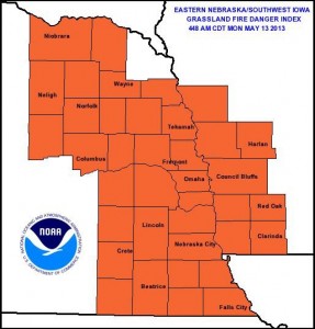
The National Weather Service in Valley, NE, says today’s Grassland Fire Danger Category in eastern Nebraska and southwest Iowa, is Very High. The next two days will be hot and dry, leaving conditions for rapid fire development extremely high. If you plan to burn remember to plan ahead and take all necessary precautions as winds and low humidity levels will create conditions for fast and out of control fires.
The Shelby County Emergency Management Agency says due to forecast low relative humidity and high wind conditions, along with the presence of dry fine fuels, the fire danger rating in the County is being upgraded to HIGH. Controlled burns should be avoided for the next couple of days. Notify your local fire chief if outdoor burning is planned.
Officials are asking participating agencies to place their “Fire Danger” signs in the High category. The rating will be re-evaluated on Thursday, May 16th, or before as conditions dictate.
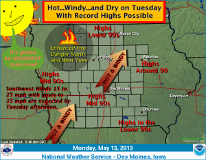
An impressive warming trend remains certain across Iowa today into Tuesday. The warmest day is forecast on Tuesday where near record or record high temperatures are anticipated. Lower to middle 90s for highs will be common over central Iowa. Windy southwest winds and very dry relative humidity will lead to an enhanced fire danger over western and northern Iowa Tuesday afternoon. A cold front will sweep across the state Tuesday night and provide a slight chance of thunderstorms. Cooler temperatures are expected by Wednesday.
The Freese-Notis (podcast) forecast for Atlantic & the KJAN listening area, and weather data for Atlantic…
Podcast: Play in new window | Download (968.0KB)
Subscribe: RSS