
A Severe Thunderstorm Watch issued at 4-p.m. remains in effect until 11-p.m. for Shelby, Pottawattamie, Mills, Montgomery, Page and Fremont Counties in southwest Iowa. The watch has been cancelled for Harrison County, as the storms make their way east. There is still a possibility of large hail, damaging winds and an isolated tornado.
356 PM CDT SAT JUN 8 2013
THE NATIONAL WEATHER SERVICE HAS ISSUED SEVERE THUNDERSTORM WATCH 289 IN EFFECT UNTIL 11 PM CDT THIS EVENING FOR THE FOLLOWING AREAS IN IOWA THIS WATCH INCLUDES 7 COUNTIES IN SOUTHWEST IOWA: FREMONT HARRISON MILLS MONTGOMERY PAGE POTTAWATTAMIE & SHELBY.
An upper level system will drop southeastward through the region later today into Sunday. This will allow for showers and thunderstorms to develop and spread across the state mainly this afternoon into tonight.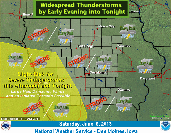 Shower and thunderstorm chances will continued across the state Sunday, before tapering off from west to east Sunday night. There is a slight risk of sever weather across west central and southwestern portions of the state this afternoon into tonight. Large hail, damaging winds, and possibly an isolated tornado are the main severe threats. Locally heavy rainfall with the potential for flash flooding is also possible tonight. Highs in the 70s are expected today, with highs in the mid 60s to lower 70s for Sunday.
SKYSCAN FORECAST SATURDAY JUNE 8TH, 2013
Today: Showers and thunderstorms likely, mainly after 4pm. Mostly cloudy, with a high near 73. Breezy, with a south southeast wind 10 to 15 mph, with gusts as high as 30 mph.
Tonight: Showers and thunderstorms, mainly before 3am. Low around 59. South southeast wind 5 to 15 mph becoming west southwest after midnight. Winds could gust as high as 20 mph.
Sunday: A chance of showers and thunderstorms. Mostly cloudy, with a high near 71. Breezy, with a west wind 10 to 15 mph, with gusts as high as 25 mph.
Monday: Mostly sunny, with a high near 78. Northwest wind 5 to 10 mph.
Tuesday: Mostly sunny, with a high near 84.
Podcast: Play in new window | Download (702.4KB)
Subscribe: RSS
The Freese-Notis (podcast) weather forecast for Atlantic & the KJAN listening area, and weather information for Atlantic…
Podcast: Play in new window | Download (1.1MB)
Subscribe: RSS
330 AM CDT FRI JUN 7 2013/Nat’l Weather Svc. – Des Moines
EARLY THIS MORNING…PARTLY CLOUDY. NORTH WIND AROUND 5 MPH.
TODAY…PARTLY SUNNY. HIGH IN THE LOWER 70S. NORTH WIND NEAR 10 MPH.
TONIGHT...PARTLY CLOUDY. LOW IN THE LOWER 50S. SOUTHEAST WIND NEAR 5 MPH.
SATURDAY…PARTLY SUNNY IN THE MORNING…THEN CLOUDY WITH A CHANCE OF THUNDERSTORMS EARLY IN THE AFTERNOON. CLOUDY WITH THUNDERSTORMS LIKELY LATE IN THE AFTERNOON. BREEZY. HIGH IN THE MID 70S. SOUTH WIND 10 TO 20 MPH. CHANCE OF THUNDERSTORMS 60 PERCENT.
SATURDAY NIGHT…CLOUDY WITH THUNDERSTORMS THROUGH MIDNIGHT…THEN PARTLY CLOUDY WITH A CHANCE OF THUNDERSTORMS AFTER MIDNIGHT. LOW AROUND 60. SOUTH WIND 10 TO 15 MPH. CHANCE OF THUNDERSTORMS 80 PERCENT.
SUNDAY…PARTLY SUNNY WITH A 30 PERCENT CHANCE OF THUNDERSTORMS. HIGH IN THE UPPER 70S. WEST WIND 10 TO 15 MPH.
SUNDAY NIGHT AND MONDAY…PARTLY CLOUDY. LOW IN THE UPPER 50S. HIGH IN THE UPPER 70S.
The Freese-Notis (podcast) weather forecast for Atlantic & the KJAN listening area, and weather information for Atlantic…
Podcast: Play in new window | Download (1.0MB)
Subscribe: RSS
402 AM CDT THU JUN 6 2013
EARLY THIS MORNING…PARTLY CLOUDY. NORTHWEST WIND 5 TO 10 MPH.
TODAY...PARTLY SUNNY. HIGH IN THE LOWER 70S. NORTH WIND 5 TO 10 MPH.
TONIGHT...PARTLY CLOUDY. LOW IN THE LOWER 50S. NORTH WIND 5 TO 10 MPH.
FRIDAY...PARTLY SUNNY. HIGH IN THE LOWER 70S. NORTH WIND NEAR 10 MPH.
FRIDAY NIGHT…PARTLY CLOUDY. LOW IN THE MID 50S. EAST WIND NEAR 5 MPH SHIFTING TO THE SOUTHEAST AROUND 5 MPH AFTER MIDNIGHT.
SATURDAY…MOSTLY CLOUDY WITH A 50 PERCENT CHANCE OF THUNDERSTORMS. HIGH IN THE MID 70S. SOUTH WIND 5 TO 15 MPH WITH GUSTS TO AROUND 25 MPH.
SATURDAY NIGHT…THUNDERSTORMS LIKELY. LOW IN THE LOWER 60S. CHANCE OF THUNDERSTORMS 70 PERCENT.
SUNDAY…PARTLY SUNNY WITH A 20 PERCENT CHANCE OF THUNDERSTORMS. HIGH IN THE UPPER 70S.
SUNDAY NIGHT AND MONDAY…PARTLY CLOUDY. LOW IN THE LOWER 60S. HIGH IN THE LOWER 80S.
The (Podcast) Freese-Notis forecast for the KJAN listening area and weather information for Atlantic, including rainfall and High/Low temps.
Podcast: Play in new window | Download (1.1MB)
Subscribe: RSS
345 AM CDT WED JUN 5 2013
EARLY THIS MORNING...CLOUDY WITH SCATTERED SHOWERS AND ISOLATED THUNDERSTORMS. WEST WIND NEAR 5 MPH. CHANCE OF PRECIPITATION 50 PERCENT.
TODAY…MOSTLY CLOUDY. SCATTERED SHOWERS AND ISOLATED THUNDERSTORMS IN THE MORNING. HIGH IN THE LOWER 70S. NORTHWEST WIND 5 TO 10 MPH. CHANCE OF PRECIPITATION 50 PERCENT.
TONIGHT...PARTLY CLOUDY. LOW IN THE LOWER 50S. NORTHWEST WIND 5 TO 10 MPH.
THURSDAY…PARTLY SUNNY. ISOLATED LIGHT SHOWERS IN THE LATE MORNING AND AFTERNOON. HIGH AROUND 70. NORTH WIND 5 TO 10 MPH. CHANCE OF SHOWERS 20 PERCENT.
THURSDAY NIGHT AND FRIDAY…PARTLY CLOUDY. LOW IN THE LOWER 50S. HIGH IN THE LOWER 70S. NORTHEAST WIND 5 TO 10 MPH.
FRIDAY NIGHT…PARTLY CLOUDY. LOW IN THE MID 50S.
SATURDAY…MOSTLY CLOUDY WITH A 40 PERCENT CHANCE OF THUNDERSTORMS. HIGH IN THE MID 70S.
SATURDAY NIGHT…THUNDERSTORMS LIKELY. LOW AROUND 60. CHANCE OF THUNDERSTORMS 60 PERCENT.
SUNDAY…MOSTLY CLOUDY WITH A 40 PERCENT CHANCE OF THUNDERSTORMS. HIGH IN THE MID 70S.


