
All 99 of Iowa’s counties are again under a heat advisory as high temperatures across the state today (Tuesday) may approach 99 degrees — and even hotter.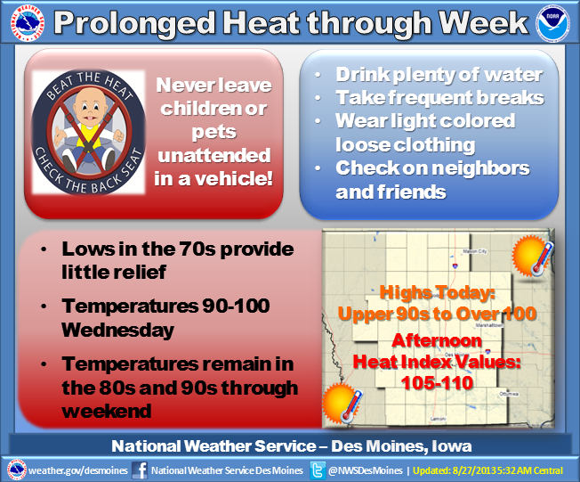 Miles Schumacher, a meteorologist at the National Weather Service, says it’ll be a steamy one. “Today may be the hottest day of the week,” Schumacher says. “Looks like we could see several areas of the state get close to record highs, right around 100, maybe just over 100, most other places at least mid-90s, with heat indices of 105 to 110.”
Many schools statewide will let classes out early again today. There were no record highs reported on Monday however Mason City set a record minimum temperature with a low of 74, breaking the record of 73 degrees from August 26th of 1955. Schumacher says a slight cool-off will arrive soon. Relief may be coming to the northeast half of the state on Wednesday and Thursday as highs may only reach the upper 80s and low 90s, though it’ll stay hot in the southwest at least until Monday or so.
Long-range forecasts call for more seasonal weather by the middle of next week, with highs back in the low to mid-80s and overnight lows in the 50s and 60s.
(Radio Iowa)
The Freese-Notis forecast for the KJAN listening area, and specific weather information for Atlantic…
Podcast: Play in new window | Download (924.2KB)
Subscribe: RSS
328 AM CDT TUE AUG 27 2013
…HEAT ADVISORY IN EFFECT UNTIL 10 PM CDT THIS EVENING...
EARLY THIS MORNING…CLEAR. SOUTHWEST WIND 10 TO 15 MPH.
TODAY…SUNNY. HOT AND HUMID. HIGH IN THE UPPER 90S. SOUTHWEST WIND 10 TO 15 MPH WITH GUSTS TO AROUND 25 MPH. HIGHEST HEAT INDEX READINGS 103 TO 108 IN THE AFTERNOON.
TONIGHT…MOSTLY CLEAR. LOW IN THE LOWER 70S. SOUTHWEST WIND NEAR 10 MPH. HIGHEST HEAT INDEX READINGS 100 TO 103 THROUGH MIDNIGHT.
WEDNESDAY…MOSTLY SUNNY. HOT AND HUMID. HIGH IN THE UPPER 90S. SOUTHEAST WIND NEAR 5 MPH. HIGHEST HEAT INDEX READINGS 104 TO 109 IN THE AFTERNOON.
WEDNESDAY NIGHT AND THURSDAY…MOSTLY CLEAR. LOW IN THE LOWER 70S. HIGH IN THE MID 90S. SOUTH WIND NEAR 10 MPH. HEAT INDEX READINGS 100 TO 104.
THURSDAY NIGHT THROUGH SATURDAY…PARTLY CLOUDY. LOW IN THE LOWER 70S. HIGH IN THE MID 90S.
…HEAT ADVISORY REMAINS IN EFFECT UNTIL 10 PM CDT THIS EVENING…
HIGH TEMPERATURES WILL VARY FROM THE MIDDLE 90S TO AROUND 100 DEGREES TODAY WITH HEAT INDEX VALUES FROM 105 TO 110 DURING THE AFTERNOON AND EARLY EVENING.
THE CUMULATIVE EFFECT OF SEVERAL DAYS OF HEAT WILL TAKE ITS TOLL…PARTICULARLY ON THOSE WITHOUT AIR CONDITIONING OR THOSE SPENDING TIME OUTSIDE. OUTDOOR ACTIVITIES SHOULD BE DELAYED TO A LATER DATE IF POSSIBLE…OR HELD IN THE MORNING TO MINIMIZE HEAT STRESS. THE IMPACTS MAY CONTINUE TO SOME EXTENT THROUGH THE LABOR DAY WEEKEND AS THE HEAT WAVE PERSISTS WITH ONLY MARGINALLY COOLER TEMPERATURES.
350 PM CDT MON AUG 26 2013/ Nat’l. Weather Service – Des Moines
…HEAT ADVISORY REMAINS IN EFFECT UNTIL 10 PM CDT TUESDAY…
HIGH TEMPERATURES WILL VARY FROM THE MIDDLE 90S TO AROUND 100 DEGREES TUESDAY WITH HEAT INDEX VALUES FROM 105 TO 110 DURING THE AFTERNOON AND EARLY EVENING. THE CUMULATIVE EFFECT OF SEVERAL DAYS OF HEAT WILL TAKE ITS TOLL…PARTICULARLY ON THOSE WITHOUT AIR CONDITIONING OR THOSE SPENDING TIME OUTSIDE.
OUTDOOR ACTIVITIES SHOULD BE DELAYED TO A LATER DATE IF POSSIBLE…OR HELD IN THE MORNING TO MINIMIZE HEAT STRESS. THE IMPACTS MAY CONTINUE TO SOME EXTENT THROUGH THE LABOR DAY WEEKEND TOO AS THE HEAT WAVE PERSISTS WITH ONLY MARGINALLY COOLER TEMPERATURES.
PRECAUTIONARY/PREPAREDNESS ACTIONS…
A HEAT ADVISORY MEANS THAT A PERIOD OF HOT TEMPERATURES IS EXPECTED. THE COMBINATION OF HOT TEMPERATURES AND HIGH HUMIDITY WILL COMBINE TO CREATE A SITUATION IN WHICH HEAT ILLNESSES ARE POSSIBLE. DRINK PLENTY OF FLUIDS…STAY IN AN AIR-CONDITIONED ROOM…STAY OUT OF THE SUN…AND CHECK UP ON RELATIVES AND NEIGHBORS.
TAKE EXTRA PRECAUTIONS IF YOU WORK OR SPEND TIME OUTSIDE. WHEN POSSIBLE…RESCHEDULE STRENUOUS ACTIVITIES TO EARLY MORNING OR EVENING. KNOW THE SIGNS AND SYMPTOMS OF HEAT EXHAUSTION AND HEAT STROKE. WEAR LIGHT WEIGHT AND LOOSE FITTING CLOTHING WHEN POSSIBLE AND DRINK PLENTY OF WATER.
TO REDUCE RISK DURING OUTDOOR WORK…THE OCCUPATIONAL SAFETY AND HEALTH ADMINISTRATION RECOMMENDS SCHEDULING FREQUENT REST BREAKS IN SHADED OR AIR CONDITIONED ENVIRONMENTS. ANYONE OVERCOME BY HEAT SHOULD BE MOVED TO A COOL AND SHADED LOCATION. HEAT STROKE IS AN EMERGENCY…CALL 9-1-1.
Iowans who don’t enjoy the extreme heat that’s in the forecast this week may find relief in a prediction from the Farmers’ Almanac. The publication’s managing editor, Sandi Duncan, says they’re predicting a winter with below normal temperatures for about two-thirds of the country.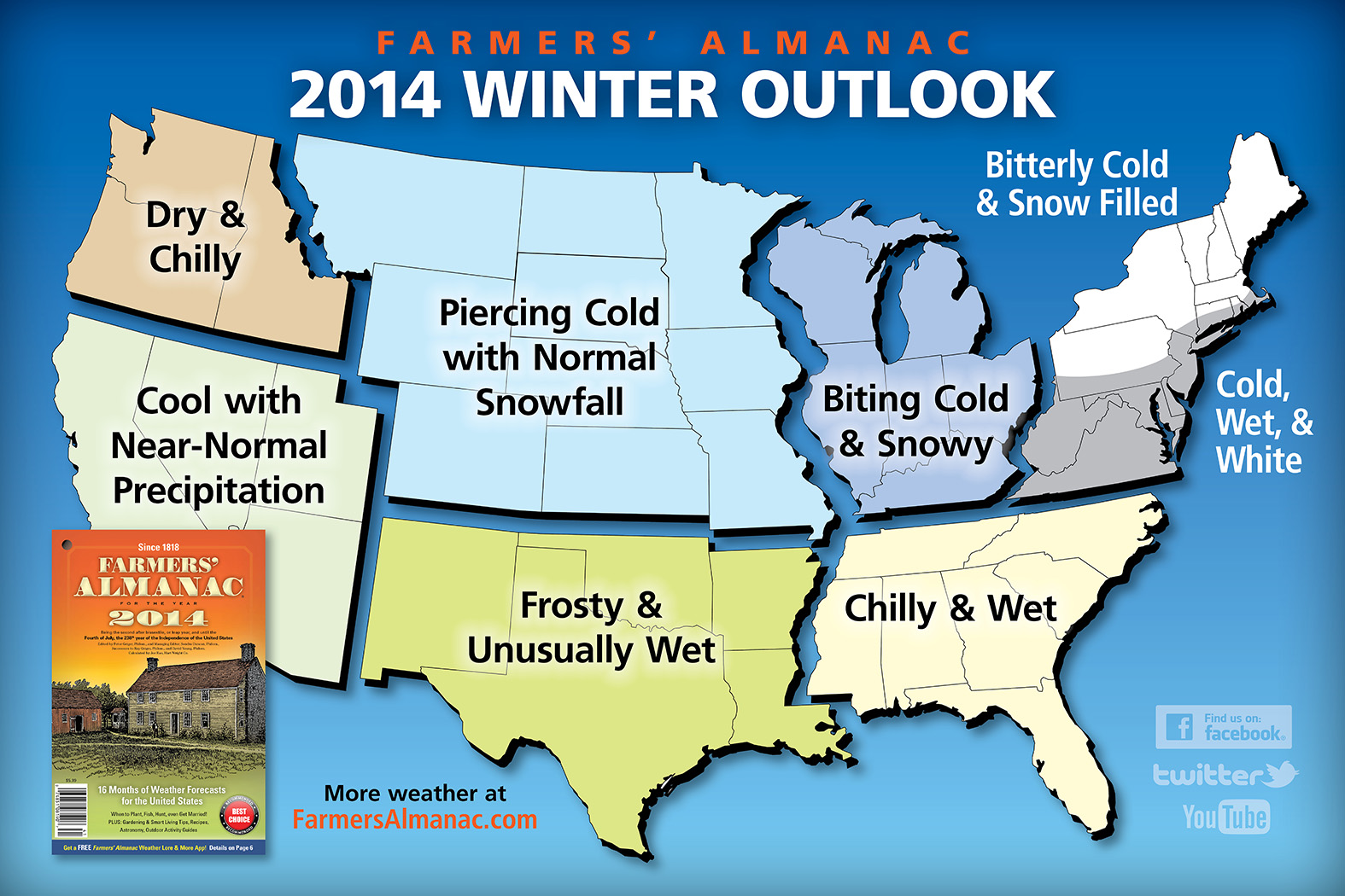 “We are saying it’s going to be a very cold winter, in fact, we’re using the words ‘piercing cold’ in your neck of the woods, with normal snowfall,” Duncan says. “So, it’s going to be one of those rough, old-fashioned, very chilly, very cold, snowy winters.”
The Farmer’s Almanac for 2014 hit newsstands today (Monday). Scientists don’t put much stock in the almanac’s weather forecasts, which Duncan says are based on a secret, mathematical and astronomical formula. “It takes things like sun spot activity, tidal action of the moon, the position of the planets, and a variety of factors into play,” Duncan says. “We’ve been predicting the weather for 197 years and people who follow our forecasts say we’re about 80 to 85 percent accurate.”
The Farmers’ Almanac, which was founded in 1818, is predicting a heavy winter storm will hit the Northeast U.S. right around the time Super Bowl is played February 2 in New Jersey.
On the web at http://www.farmersalmanac.com/
(Radio Iowa)
Shelby County Emergency Management Coordinator Bob Seivert says the local Fire danger signs have been in the “Low” category since spring, and while they are not implementing the bi-weekly fire danger assessments, given the general lack of rainfall…and expected very hot and windy condition expected to prevail through the next week…Seivert advises businesses and area fire departments to move the fire danger signs into the “Moderate” category.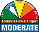
Seivert asks residents of Shelby County to “Please report a planned or controlled burn prior to ignition,” by calling 712-755-2124. If you need help in determining if the burn can be conducted safely, you’re asked to contact the Emergency Mgt Agency, or your Fire Chief.
Seivert says his office will continue to monitor conditions and keep residents and the media updated as necessary.
The entire state is under a heat advisory today (Monday), as temperatures are going to push up into the 90’s. National Weather Service meteorologist, Brad Small, says it’s not that unusual to see such high temperatures at the end of August. “What is unusual is how long this is going to last,” Small says. “If we end up with how the forecast is expected to pan out, it will be the hottest end of August that we’ve seen on record for that seven-day period from yesterday through the 31st. So, it will be very unusual to see temperatures this warm for this long.”
Not only are the temperatures heating up — but for areas of the state that have had some recent moisture — the humidity is also a factor. “We’ve increased both the heat and humidity from what we’ve seen from earlier in the summer, especially recently what we saw right around the state fair,” according to Small. “Definitely a big change in that regard, and we’ll be pushing records by Tuesday.” When you factor in the actual temperature and the relative humidity, you get the heat index. That index is expected to be over 100 in many parts of the state this week.
The forecast shows just a slim chance for a little relief from the heat. He says there may be a brief cold front dropping down on north-east Iowa around Wednesday. “That will be brief and very temporary, if it even occurs at all, and most of the state will see really little change, with highs in the 90’s at least through the holiday weekend,” Small says.
While people can turn on the air conditioner to seek relief, the crops in Iowa’s fields don’t have that option. “We’re gonna really increase things as far as the stress on the crops with the heat and the lack of moisture. North-east Iowa is a little better off — they’ve had some rains recently — but the south-west two-thirds of the state is in drought conditions right now and it will continue to worsen,” Small says. Polk County in central Iowa is also under an excessive heat warning for today (Monday).
(Radio Iowa)
Cass County Emergency Management Coordinator Mike Kennon reports several facilities have offered to serve as cooling stations for Cass County residents needing to find relief from the prolonged high heat and humidity that is expected to blanket the area through this week.
The cooling station in Atlantic, located at the Nishna Valley YMCA at 1100 Maple Street, is open from 4:30 a.m. to 10 p.m. Monday thru Thursday and 4:30 a.m. to 8 p.m. on Friday.
The Griswold City Library is open 10 a.m. to 12:30 p.m. and 1:30 p.m. to 6:00 p.m. M-F.
The Anita Health and Wellness Center will be available as a cooling station from 8 a.m. to 5 p.m. Monday thru Wednesday.
The National Weather Service has predicted afternoon heat indices over 100F for the area through the week. Kennon says residents should “Drink plenty of fluids, avoid strenuous outdoor activity during the heat of the day, stay out of the sun, and check on relatives, neighbors, the elderly and pets. Anyone overcome by heat should be moved to a cool and shaded location. Heat stroke is an emergency…call 9-1-1.”
The Freese-Notis forecast for the KJAN listening area, weather information for Atlantic, and a Heat Advisory notification.
Podcast: Play in new window | Download (1.0MB)
Subscribe: RSS


