
AREA COUNTIES: SAC-CRAWFORD-CARROLL-AUDUBON-GUTHRIE-DALLAS-CASS-ADAIR-MADISON-TAYLOR-RINGGOLD–
247 AM CDT MON SEP 9 2013
VERY HOT CONDITIONS ARE FORECAST FOR CENTRAL IOWA TODAY WITH NEAR RECORD HIGH TEMPERATURES OF 95 TO AROUND 100 DEGREES FORECAST. DEW POINT VALUES BY THE AFTERNOON WILL DROP INTO THE 50S TO LOWER 60S…COMBINED WITH TEMPERATURES THIS WILL ALLOW THE RELATIVE HUMIDITY VALUES TO DROP TO 25 TO 30 PERCENT.
THESE CONDITIONS WILL ACCELERATE THE ONSET OF DEHYDRATION. IT IS RECOMMENDED FOR PERSONS THAT MUST BE OUTDOORS TO DRINK PLENTY OF WATER…TAKE FREQUENT BREAKS AND WEAR LIGHT COLORED AND LOOSE CLOTHING. OUTSIDE EXERCISE SHOULD TAKE PLACE DURING THE MORNING OR DELAYED UNTIL THE EVENING.
A COLD FRONT WILL DROP SLOWLY THROUGH IOWA TUESDAY AND TUESDAY NIGHT. THE HEAT WILL LIKELY PERSIST ACROSS SOUTHERN IOWA THROUGH TUESDAY.
IN ADDITION…THERE IS AN ELEVATED FIRE DANGER MONDAY AFTERNOON ESPECIALLY ACROSS AREAS OF CENTRAL AND SOUTHERN IOWA WHERE DROUGHT CONDITIONS HAVE RETURNED. THE COMBINATION OF LOW HUMIDITY…A GUSTY 20 TO 25 MPH SOUTHWEST WIND AND DRYING VEGETATION COULD LEAD TO QUICK FIRE GROWTH SHOULD A FIRE BE IGNITED.
AREA COUNTIES: SAC-CRAWFORD-CARROLL-AUDUBON-GUTHRIE-DALLAS-CASS-ADAIR-MADISON-ADAMS-UNION-TAYLOR-RINGGOLD
518 AM CDT SUN SEP 8 2013
…VERY HOT CONDITIONS TO RETURN TO IOWA MONDAY…
VERY HOT CONDITIONS WILL ARRIVE MONDAY WITH NEAR RECORD HIGH
TEMPERATURES OF 95 TO 100 DEGREES FORECAST. DEW POINT VALUES BY
THE AFTERNOON WILL DROP INTO THE 50S TO LOWER 60S AND COMBINED
WITH THE TEMPERATURES WILL ALLOW THE RELATIVE HUMIDITY VALUES TO
DROP TO 25 TO 30 PERCENT. THESE CONDITIONS WILL ACCELERATE THE
ONSET OF DEHYDRATION. IT IS RECOMMENDED FOR PERSONS THAT MUST BE
OUTDOORS TO DRINK PLENTY OF WATER…TAKE FREQUENT BREAKS AND
WEAR LIGHT COLORED AND LOOSE CLOTHING. OUTSIDE EXERCISE SHOULD
TAKE PLACE DURING THE MORNING OR DELAYED UNTIL THE EVENING.
A COLD FRONT WILL DROP SLOWLY THROUGH IOWA MONDAY NIGHT AND TUESDAY. THE HEAT WILL LIKELY PERSIST ACROSS SOUTHERN IOWA THROUGH TUESDAY.
IN ADDITION…THERE WILL BE AN ELEVATED WILD FIRE DANGER MONDAY
AFTERNOON ESPECIALLY ACROSS AREAS OF CENTRAL AND SOUTHERN IOWA
WHERE DROUGHT CONDITIONS HAVE RETURNED. THE COMBINATION OF LOW
HUMIDITY…BREEZY SOUTHWEST WINDS AND DRYING VEGETATION COULD LEAD TO QUICK FIRE GROWTH SHOULD A FIRE BE IGNITED.
344 AM CDT SUN SEP 8 2013
…NEAR RECORD HIGHS MONDAY…
EARLY THIS MORNING…PARTLY CLOUDY. PATCHY FOG. NORTHEAST WIND 5 TO 10 MPH.
TODAY…PARTLY SUNNY. PATCHY FOG THROUGH MID MORNING. HIGH IN THE LOWER 90S. EAST WIND 5 TO 10 MPH.
TONIGHT…MOSTLY CLEAR. LOW IN THE UPPER 60S. SOUTHEAST WIND 5 TO 10 MPH.
MONDAY...MOSTLY SUNNY. HOT…BREEZY. HIGH IN THE MID 90S. SOUTH WIND 5 TO 10 MPH WITH GUSTS TO AROUND 20 MPH INCREASING TO SOUTHWEST 15 TO 20 MPH WITH GUSTS TO AROUND 30 MPH IN THE AFTERNOON.
MONDAY NIGHT…MOSTLY CLEAR. LOW IN THE UPPER 60S. SOUTHWEST WIND 5 TO 10 MPH. GUSTS UP TO 25 MPH THROUGH MIDNIGHT.
TUESDAY…PARTLY SUNNY. A 20 PERCENT CHANCE OF THUNDERSTORMS IN THE AFTERNOON. HIGH AROUND 90. WEST WIND NEAR 10 MPH.
TUESDAY NIGHT…PARTLY CLOUDY WITH A 40 PERCENT CHANCE OF THUNDERSTORMS. LOW IN THE MID 60S.
WEDNESDAY…PARTLY SUNNY WITH A 20 PERCENT CHANCE OF THUNDERSTORMS. HIGH IN THE MID 80S.
Today: Isolated showers and thunderstorms after 5pm. Partly sunny, with a high near 94. South wind 7 to 10 mph becoming west northwest in the afternoon. Chance of precipitation is 10%.
Tonight: Isolated showers and thunderstorms before 7pm. Partly cloudy, with a low around 69. Northeast wind around 5 mph. Chance of precipitation is 10%.
Sunday: Mostly sunny, with a high near 92. East wind 5 to 10 mph.
Sunday Night: Partly cloudy, with a low around 68. East southeast wind around 7 mph.
Monday: Sunny, with a high near 96. Breezy, with a south southwest wind 6 to 16 mph, with gusts as high as 23 mph.
Monday Night: Mostly clear, with a low around 68.
Tuesday: A 30 percent chance of showers and thunderstorms. Mostly sunny, with a high near 89.
Tuesday Night: A 50 percent chance of showers and thunderstorms. Mostly cloudy, with a low around 65.
Wednesday: Mostly sunny, with a high near 84.
Podcast: Play in new window | Download (688.0KB)
Subscribe: RSS
The (Podcast) Freese-Notis weather forecast for the KJAN listening area, and weather information for Atlantic…
Podcast: Play in new window | Download (1.0MB)
Subscribe: RSS
About one-third of Iowa is now in a severe drought and the increasingly dry conditions raise the risk for grass fires. State Fire Marshal Ray Reynolds says rural residents who burn ditches or large piles of debris need to be especially careful. “I think people underestimate just how dry the conditions are,” Reynolds says. “The other thing we see, as we start to get into the fields in the next month or so, equipment and machinery are another common cause of fires.”
Prairie or grass fires are also often ignited by discarded cigarettes.”We see an awful lot of people who are throwing cigarettes out of their cars and I’ve not seen a car yet that doesn’t come with an ashtray. We would just encourage people who are traveling through our state to put their cigarettes out in their vehicle in the ashtray,” Reynolds says. A simple spark, combined with the recent low humidity and a little wind, can quickly turn into a large fire.
Reynolds says every year, at least a few Iowans are burned or even killed in “controlled burns” that get out of control. “If we could just remind Iowans…if you absolutely have to burn, make sure you have a water source close by and just be cognizant of the conditions when you burn,” Reynolds says.
(Radio Iowa)
345 AM CDT FRI SEP 6 2013
EARLY THIS MORNING…PARTLY CLOUDY. SOUTH WIND NEAR 5 MPH.
TODAY…PARTLY SUNNY. HIGH IN THE LOWER 90S. SOUTH WIND 5 TO 15 MPH.
TONIGHT…PARTLY CLOUDY. LOW IN THE UPPER 60S. SOUTH WIND 5 TO 10 MPH.
SATURDAY…PARTLY SUNNY. HOT. HIGH IN THE MID 90S. SOUTHWEST WIND 5 TO 10 MPH SHIFTING TO THE NORTHWEST IN THE AFTERNOON.
SATURDAY NIGHT…PARTLY CLOUDY WITH A 20 PERCENT CHANCE OF THUNDERSTORMS. LOW IN THE UPPER 60S. NORTHEAST WIND NEAR 5 MPH.
SUNDAY…PARTLY SUNNY. HIGH IN THE LOWER 90S. EAST WIND 5 TO 15 MPH.
SUNDAY NIGHT AND MONDAY…PARTLY CLOUDY. LOW IN THE UPPER 60S. HIGH IN THE MID 90S.
DES MOINES, Iowa (AP) – Drought conditions have worsened in a portion of the Midwest including Iowa, the nation’s leading corn producer, as the region experienced its hottest week of the year.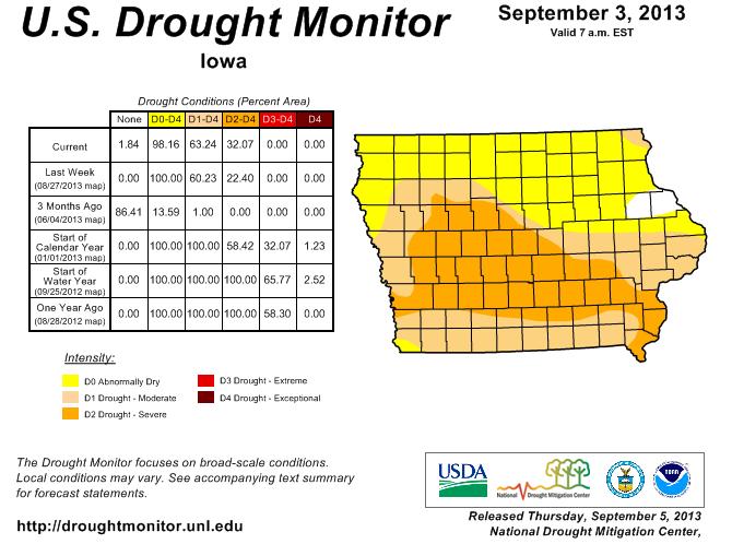 The extreme heat and near record low August rainfall combined to expand drought conditions from the eastern Dakotas southeastward into western Illinois. Iowa saw its warmest week since July 2012, with highs topping 104 at Des Moines on Aug. 30.
About 98 percent of the state is in drought. Severe drought expanded to 32 percent of the state from 22 percent the week before. Conditions are mostly unchanged in Nebraska and Kansas. The weekly drought monitor, which tracks conditions from Aug. 27 through Tuesday morning, shows 61.7 percent of the contiguous United States in drought, nearly the same as the week before.
The (Podcast) Freese-Notis weather forecast for the KJAN listening area, and weather information for Atlantic…
Podcast: Play in new window | Download (881.3KB)
Subscribe: RSS
Today: Isolated showers before 10am. Mostly sunny, with a high near 89. Light east southeast wind becoming south southeast 5 to 10 mph in the afternoon. Chance of precipitation is 20%.
Tonight: Partly cloudy, with a low around 62. South southeast wind around 6 mph becoming calm in the evening.
Friday: Mostly sunny, with a high near 91. Light south wind increasing to 10 to 15 mph in the morning. Winds could gust as high as 20 mph.
Friday Night: Partly cloudy, with a low around 68. South wind 6 to 8 mph.
Saturday: Mostly sunny, with a high near 94. Southwest wind 5 to 11 mph.
Saturday Night: Mostly cloudy, with a low around 68.
Sunday: Mostly sunny, with a high near 91.
Sunday Night: Partly cloudy, with a low around 69.
Monday: Sunny, with a high near 94.


