
The National Weather Service at 8:20-p.m. Thursday, issued SEVERE THUNDERSTORM WATCH #537, which is in effect until 5-a.m. Friday. Area Counties included in the SEVERE THUNDERSTORM WATCH: ADAIR ADAMS AUDUBON CARROLL CASS CRAWFORD DALLAS FREMONT HARRISON GUTHRIE MADISON MILLS MONTGOMERY PAGE POTTAWATTAMIE RINGGOLD SAC SHELBY TAYLOR AND UNION.
PRIMARY THREATS INCLUDE…
NUMEROUS LARGE HAIL EVENTS LIKELY WITH A FEW VERY LARGE HAIL EVENTS TO 2.5 INCHES IN DIAMETER POSSIBLE; SEVERAL DAMAGING WIND GUSTS TO 70 MPH POSSIBLE; A FEW TORNADOES POSSIBLE
THE SEVERE THUNDERSTORM WATCH AREA IS APPROXIMATELY ALONG AND 140 STATUTE MILES EAST AND WEST OF A LINE FROM 10 MILES WEST SOUTHWEST OF FALLS CITY NEBRASKA TO 70 MILES NORTH OF DES MOINES, IOWA.
A SEVERE THUNDERSTORM WATCH MEANS CONDITIONS ARE FAVORABLE FOR THE DEVELOPMENT OF SEVERE STORMS IN AND CLOSE TO THE WATCH AREA. PERSONS IN THESE AREAS SHOULD BE ON THE LOOKOUT FOR THREATENING WEATHER CONDITIONS AND LISTEN FOR LATER STATEMENTS AND POSSIBLE WARNINGS. SEVERE THUNDERSTORMS CAN AND OCCASIONALLY DO PRODUCE TORNADOES.
The Iowa Storm Chasing Network (http://iowachase.com) reports the Severe Storm Prediction Center (SPC) is currently watching parts of southwestern Iowa for the probability of issuing a severe thunderstorm watch.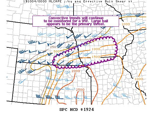 It appears more robust storm initiation will occur over the next hour or two across south central Iowa. A large hail and perhaps an isolated tornado threat may develop over the next several hours as attempts are made for storms to increase in coverage and intensity across central Iowa
COUNTIES: AUDUBON-GUTHRIE-DALLAS-CASS-ADAIR-MADISON-ADAMS-UNION-TAYLOR-RINGGOLD
THIS AFTERNOON AND TONIGHT: SCATTERED THUNDERSTORMS ARE POSSIBLE DURING THE EVENING…BUT ARE MORE LIKELY TO REDEVELOP OVERNIGHT INTO EARLY FRIDAY MORNING. A FEW ISOLATED SEVERE STORMS COULD PRODUCE LARGE HAIL AND DAMAGING WINDS. LOCALLY HEAVY IS ALSO POSSIBLE.
FRIDAY: STRONG TO SEVERE THUNDERSTORMS ARE EXPECTED LATE FRIDAY AFTERNOON AND INTO THE EARLY EVENING HOURS. THE PRIMARY THREATS WILL BE HAIL UP TO GOLF BALL SIZE AND 65 MPH WINDS. THERE IS A POTENTIAL FOR AN ISOLATED TORNADO OR TWO AS WELL.
.SPOTTER INFORMATION STATEMENT…
SPOTTER ACTIVATION MAY BE REQUIRED THIS EVENING AND AGAIN FRIDAY AFTERNOON AND EVENING.
DES MOINES, Iowa (AP) — An unusual strong storm front is threatening the Midwest from the central Plains to the Mississippi Valley over the next several days. The National Weather Service’s Storm Prediction Center in Norman, Okla., says the system could bring heavy thunder, wind, rain and possibly tornadoes on Friday.
Meteorologist Gregory Carbin says about one-third of Iowa and parts of southern Minnesota have a 45 percent chance of severe storms, More than 1 million people live in that risk area.
Parts of Kansas, Nebraska, Missouri and Wisconsin are also on the storm front’s path. Areas as far south as Oklahoma and Texas could be affected. Meteorologists say this is the first time since at least 2000 that a storm this size in the region has been forecast in October a day in advance.
The National Weather Service says several rounds of thunderstorms are expected across Iowa today through Friday evening. There is a threat for severe weather over central and western Iowa this afternoon and evening with the potential for large hail and damaging winds. An isolated tornado is also possible.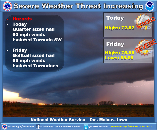 Additional storms are expected to develop over northern Iowa by Friday afternoon. Large hail, damaging winds and a few tornadoes are possible with this activity. One final line of storms will arrive Friday evening and will bring and additional severe weather threat. Storms will end Saturday as much cooler weather arrives. Sunday will remain cool with a few showers forecast over the northern half of the state. Seasonal and mainly dry conditions are expected for the start of next week.
COUNTIES: MONONA-HARRISON-SHELBY-POTTAWATTAMIE-MILLS-MONTGOMERY-FREMONT-PAGE…
TODAY AND TONIGHT: SEVERE THUNDERSTORMS ARE POSSIBLE THIS AFTERNOON…MAINLY ALONG AND NORTH OF INTERSTATE 80. A STATIONARY FRONT WILL BE THE FOCUS FOR THUNDERSTORMS DEVELOPMENT THIS AFTERNOON AS THE ATMOSPHERE BECOME UNSTABLE. THUNDERSTORMS ARE EXPECTED TO CONTINUE INTO THE EVENING HOURS. LARGE HAIL AND DAMAGING WIND WILL BE THE PRIMARY HAZARDS.
FRIDAY: LARGE HAIL…GUSTY WINDS AND ISOLATED TORNADOES ARE ALL POSSIBLE FROM MID FRIDAY AFTERNOON INTO FRIDAY EVENING. SEVERE
THUNDERSTORMS ARE EXPECTED TO DEVELOP FRIDAY AFTERNOON AS A STRONG STORM SYSTEM MOVES INTO THE AREA.
PARTS OF NORTHEAST NEBRASKA AND WEST CENTRAL IOWA COULD SEE THEIR
FIRST FREEZE OF THE SEASON SATURDAY NIGHT INTO SUNDAY MORNING AS
MUCH COLDER AIR DROPS SOUTH.
COUNTIES: SAC-CRAWFORD-CARROLL-AUDUBON-GUTHRIE-DALLAS-CASS-ADAIR-MADISON-ADAMS-UNION-TAYLOR-RINGGOLD
TODAY AND TONIGHT: THUNDERSTORMS ARE EXPECTED ACROSS MUCH OF THE AREA TODAY AND TONIGHT. A FEW SEVERE STORMS ARE POSSIBLE. QUARTER SIZED HAIL AND 60 MPH WINDS ARE THE PRIMARY THREATS. AN ISOLATED TORNADO IS POSSIBLE BETWEEN 3 PM AND 9 PM IN AN AREA WEST OF INTERSTATE 35 AND SOUTH OF HIGHWAY 30.
FRIDAY: ANOTHER ROUND OF STRONG TO SEVERE THUNDERSTORMS IS EXPECTED FRIDAY AFTERNOON NORTH OF HIGHWAY 30 THEN ACROSS THE ENTIRE AREA FRIDAY NIGHT. GOLF BALL SIZED HAIL AND 65 MPH WINDS WILL BE THE PRIMARY THREATS. THERE IS THE POTENTIAL FOR A FEW TORNADOES ESPECIALLY OVER NORTH CENTRAL IOWA FRIDAY AFTERNOON AND ACROSS CENTRAL IOWA LATE FRIDAY AFTERNOON AND EVENING.
SPOTTER INFORMATION STATEMENT… SPOTTER ACTIVATION MAY BE REQUIRED THIS AFTERNOON AND EVENING THEN AGAIN FRIDAY AFTERNOON AND EVENING.
The Freese-Notis Forecast for the KJAN listening area and weather information for Atlantic…
Podcast: Play in new window | Download (1.2MB)
Subscribe: RSS
359 AM CDT THU OCT 3 2013
EARLY THIS MORNING...CLOUDY WITH A 40 PERCENT CHANCE OF THUNDERSTORMS. WARMER. SOUTH WIND NEAR 10 MPH.
TODAY…CLOUDY IN THE MORNING THEN BECOMING PARTLY SUNNY. A CHANCE OF THUNDERSTORMS THROUGH MID MORNING…THEN THUNDERSTORMS LIKELY BEFORE NOON. A CHANCE OF THUNDERSTORMS IN THE AFTERNOON. HIGH IN THE LOWER 80S. SOUTH WIND 5 TO 15 MPH WITH GUSTS TO AROUND 25 MPH. CHANCE OF THUNDERSTORMS 60 PERCENT.
TONIGHT…MOSTLY CLOUDY WITH THUNDERSTORMS LIKELY THROUGH MIDNIGHT…THEN PARTLY CLOUDY WITH A CHANCE OF THUNDERSTORMS AFTER MIDNIGHT. LOW IN THE MID 60S. SOUTH WIND 5 TO 10 MPH. CHANCE OF THUNDERSTORMS 70 PERCENT.
FRIDAY…PARTLY SUNNY WITH A 50 PERCENT CHANCE OF THUNDERSTORMS. BREEZY. HIGH IN THE LOWER 80S. SOUTH WIND 10 TO 20 MPH WITH GUSTS TO AROUND 30 MPH.
FRIDAY NIGHT…MOSTLY CLOUDY WITH THUNDERSTORMS LIKELY THROUGH MIDNIGHT…THEN PARTLY CLOUDY WITH A CHANCE OF THUNDERSTORMS AFTER MIDNIGHT. COOLER. LOW AROUND 50. SOUTHWEST WIND 10 TO 15 MPH WITH GUSTS TO AROUND 25 MPH. CHANCE OF THUNDERSTORMS 60 PERCENT.
SATURDAY…PARTLY SUNNY. BREEZY. MUCH COOLER. HIGH IN THE UPPER 50S. TEMPERATURE STEADY OR SLOWLY FALLING IN THE AFTERNOON. WEST WIND 15 TO 25 MPH WITH GUSTS TO AROUND 35 MPH.
SATURDAY NIGHT THROUGH SUNDAY NIGHT…PARTLY CLOUDY. LOW IN THE UPPER 30S. HIGH IN THE MID 50S.
The warm and sunny conditions around Iowa are about to change. Kurt Kotenberg is a meteorologist at the National Weather Service. “We’re going to go, basically, from 80s and sunshine the past couple days, to stormy Thursday and especially Friday, to cloudy, cold and gloomy for this weekend,” Kotenberg says.
Clouds will be on the increase across the state tonight, with some areas possibly receiving rain. A better chance for rain arrives tomorrow (Thursday). “Especially from around the Des Moines metro area and locations to the north, we’ve got a 60 to 70 percent chance (of rain),” Kotenberg says. “Heading into Friday, we have a greater chance of strong to severe thunderstorms across much of Iowa. We’ll definitely be watching that closely.”
More fall-like temperatures will arrive on Saturday. “Saturday will be pretty cloudy all day, kind of a very raw November-like day…kind of drizzling all day and cold,” Kotenberg says. “Temperatures will struggle to reach the mid to upper 50s and it will be windy also.”
Winds on Saturday will be between 15 and 25 miles per hour, according to Kotenberg. Sunday’s forecast calls for a clear to partly cloudy sky and highs mainly in the 50s.
(Radio Iowa)
(Issued by the Nat’l. Weather Service in Des Moines, 10/2/13)
THURSDAY THROUGH SATURDAY…
PERIODS OF THUNDERSTORMS ARE FORECAST FROM THURSDAY THROUGH SATURDAY. THERE IS A THREAT FOR A FEW SEVERE STORMS THURSDAY AFTERNOON AND EVENING THEN AGAIN ON FRIDAY. LARGE HAIL AND DAMAGING WINDS WILL BE THE PRIMARY THREAT. THE POTENTIAL FOR AN ISOLATE TORNADO OR TWO DOES EXIST BOTH DAYS.
SPOTTER INFORMATION STATEMENT…
SPOTTER ACTIVATION MAY BE REQUIRED THURSDAY AND FRIDAY.
ALSO….COLD WEATHER WILL MOVE OVER THE AREA THIS WEEKEND AFTER THE SYSTEM DEPARTS THE REGION. TEMPERATURES WILL FALL INTO THE 30S BY SUNDAY MORNING AND PARTS OF NORTHEAST NEBRASKA AND WEST CENTRAL IOWA COULD SEE THEIR FIRST FREEZE OF THE SEASON.


