
1011 AM CDT WED MAR 26 2014
…THIS MESSAGE IS FOR TEST PURPOSES ONLY…
THE NATIONAL WEATHER SERVICE IN OMAHA HAS ISSUED A
* THIS IS A TEST MESSAGE. TORNADO WARNING FOR…
PAGE COUNTY IN SOUTHWEST IOWA…
HARRISON COUNTY IN SOUTHWEST IOWA…
MONTGOMERY COUNTY IN SOUTHWEST IOWA…
MONONA COUNTY IN WEST CENTRAL IOWA…
MILLS COUNTY IN SOUTHWEST IOWA…
SHELBY COUNTY IN SOUTHWEST IOWA…
FREMONT COUNTY IN SOUTHWEST IOWA…
POTTAWATTAMIE COUNTY IN SOUTHWEST IOWA…
NWS STORM PREDICTION CENTER NORMAN OK
950 AM CDT WED MAR 26 2014
THE NWS STORM PREDICTION CENTER HAS ISSUED A…TEST…
* TORNADO WATCH FOR PORTIONS OF
IOWA
* EFFECTIVE THIS WEDNESDAY MORNING FROM 950 AM UNTIL 1100 AM CDT.
* PRIMARY THREATS INCLUDE…
THE TEST TORNADO WATCH AREA IS APPROXIMATELY ALONG AND 95 STATUTE
MILES NORTH AND SOUTH OF A LINE FROM 20 MILES WEST NORTHWEST OF
DENISON IOWA TO 35 MILES EAST NORTHEAST OF CEDAR RAPIDS IOWA.
PRECAUTIONARY/PREPAREDNESS ACTIONS…
REMEMBER…A TORNADO WATCH MEANS CONDITIONS ARE FAVORABLE FOR
TORNADOES AND SEVERE THUNDERSTORMS IN AND CLOSE TO THE WATCH
AREA. PERSONS IN THESE AREAS SHOULD BE ON THE LOOKOUT FOR
THREATENING WEATHER CONDITIONS AND LISTEN FOR LATER STATEMENTS
AND POSSIBLE WARNINGS.
The (podcast) Freese-Notis weather forecast for the KJAN listening area, and weather information for Atlantic.
Podcast: Play in new window | Download (1.6MB)
Subscribe: RSS
346 AM CDT WED MAR 26 2014
…WIND ADVISORY IN EFFECT FROM 1 PM THIS AFTERNOON TO 7 PM CDT THIS EVENING…
EARLY THIS MORNING…MOSTLY CLEAR. SOUTH WIND 5 TO 10 MPH.
TODAY…MOSTLY SUNNY. WINDY. MUCH WARMER. HIGH IN THE LOWER 60S. SOUTH WIND 10 TO 20 MPH WITH GUSTS TO AROUND 35 MPH INCREASING TO 25 TO 30 MPH WITH GUSTS TO AROUND 45 MPH IN THE AFTERNOON.
TONIGHT…CLOUDY…WINDY. NOT AS COOL. A SLIGHT CHANCE OF LIGHT SHOWERS THROUGH MIDNIGHT…THEN SHOWERS LIKELY AND ISOLATED THUNDERSTORMS AFTER MIDNIGHT. LOW IN THE LOWER 40S. SOUTH WIND 25 TO 30 MPH DECREASING TO 15 TO 25 MPH AFTER MIDNIGHT. GUSTS UP TO 40 MPH. CHANCE OF PRECIPITATION 70 PERCENT.
THURSDAY…SHOWERS AND ISOLATED THUNDERSTORMS THROUGH MID MORNING… THEN SHOWERS LIKELY AND ISOLATED THUNDERSTORMS IN THE LATE MORNING AND AFTERNOON. BREEZY…COOLER. HIGH IN THE LOWER 50S. SOUTH WIND 10 TO 20 MPH SHIFTING TO THE WEST 5 TO 15 MPH IN THE AFTERNOON. CHANCE OF PRECIPITATION 80 PERCENT.
THURSDAY NIGHT AND FRIDAY…MOSTLY CLOUDY. LOW IN THE UPPER 20S. HIGH 46 TO 51. NORTHEAST WIND 5 TO 15 MPH WITH GUSTS TO AROUND 25 MPH.
FRIDAY NIGHT…MOSTLY CLOUDY. LOW IN THE UPPER 20S.
SATURDAY…MOSTLY SUNNY. HIGH IN THE MID 50S.
COUNTIES: SAC-CRAWFORD-CARROLL-AUDUBON-GUTHRIE-DALLAS-CASS-ADAIR- MADISON-ADAMS-UNION-TAYLOR-RINGGOLD
337 AM CDT WED MAR 26 2014
A WIND ADVISORY IS IN EFFECT FROM 1 PM TODAY UNTIL 7 PM THIS EVENING, AND FROM 1-TO 8-PM FOR MONONA-HARRISON-SHELBY-POTTAWATTAMIE-MILLS-MONTGOMERY-FREMONT AND PAGE COUNTIES.
* TIMING…SOUTH WINDS WILL INCREASE SLOWLY THIS MORNING AND WILL BE COME STRONG BY THE EARLY AFTERNOON HOURS UNTIL AROUND SUNSET.
* WINDS…SOUTH TO SOUTHEAST WINDS OF 10 TO 20 MPH THIS MORNING WILL BECOME SOUTH BY THIS AFTERNOON AND INCREASE TO AROUND 30 MPH WITH GUSTS TO AROUND 45 MPH.
* IMPACTS…ANY OUTDOOR OBJECTS THAT ARE NOT FASTENED DOWN WILL LIKELY BE BLOWN AROUND DUE TO THE STRONG WINDS. IN ADDITION…THERE WILL BE AN ELEVATED FIRE DANGER THIS AFTERNOON. ANY FIRE THAT STARTS MAY SPREAD QUICKLY DUE TO THE COMBINATION OF HUMIDITY AROUND 30 PERCENT WITH THE STRONG WINDS AND DRY GRASSES.
PRECAUTIONARY/PREPAREDNESS ACTIONS…
A WIND ADVISORY MEANS THAT WINDS OF 45 MPH ARE EXPECTED. WINDS THIS STRONG CAN MAKE DRIVING DIFFICULT…ESPECIALLY FOR HIGH PROFILE VEHICLES. USE EXTRA CAUTION.
3:59-a.m. CDT March 25 2014
EARLY THIS MORNING…PARTLY CLOUDY. NORTHWEST WIND 10 TO 15 MPH.
TODAY…SUNNY…BREEZY. HIGH IN THE MID 30S. NORTHWEST WIND 10 TO 20 MPH WITH GUSTS TO AROUND 30 MPH.
TONIGHT…MOSTLY CLEAR. LOW IN THE LOWER 20S. WEST WIND NEAR 10 MPH SHIFTING TO THE SOUTHEAST AFTER MIDNIGHT.
WEDNESDAY…MOSTLY SUNNY. WINDY. MUCH WARMER. HIGH IN THE UPPER 50S. SOUTH WIND 15 TO 20 MPH INCREASING TO 25 TO 30 MPH IN THE AFTERNOON. GUSTS UP TO 40 MPH.
WEDNESDAY NIGHT…MOSTLY CLOUDY. A CHANCE OF SHOWERS AND ISOLATED THUNDERSTORMS AFTER MIDNIGHT. WINDY. NOT AS COOL. LOW IN THE LOWER 40S. SOUTH WIND 15 TO 30 MPH. CHANCE OF PRECIPITATION 50 PERCENT.
THURSDAY…SHOWERS LIKELY AND ISOLATED THUNDERSTORMS. BREEZY. HIGH AROUND 50. SOUTH WIND AROUND 15 MPH SHIFTING TO THE WEST IN THE AFTERNOON. CHANCE OF PRECIPITATION 70 PERCENT.
THURSDAY NIGHT…MOSTLY CLOUDY. A 40 PERCENT CHANCE OF RAIN THROUGH MIDNIGHT. COLDER. LOW AROUND 30.
FRIDAY..MOSTLY CLOUDY. HIGH IN THE MID 40S.
This week’s “Fire Danger” index has been moved to the “High” category this week, in Shelby County. Emergency Management Coordinator Bob Seivert says the risk of controlled burn spreading beyond their intended scope is increasing due to the sunny and windy conditions expected Tuesday and Wednesday. 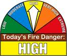
Seivert asks residents of Shelby County to please remember to contact the EMA at 712-755-2124 and your local fire Chief to report your controlled burn prior to starting any fires.
The Freese-Notis weather forecast and weather information for Atlantic.
Podcast: Play in new window | Download (1,009.9KB)
Subscribe: RSS
LIGHT SNOW FELL OVER PORTIONS OF THE STATE OVERNIGHT. THE HEAVIEST
SNOW FELL ALONG A CORRIDOR FROM SAC CITY THROUGH THE DES MOINES
METRO AREA SOUTHEAST TOWARDS CHARITON. THE AREA OF SNOW IS
EXPECTED TO EXPAND THROUGH THE MORNING HOURS. ACUMULATIONS WILL BE
LIGHT THROUGH THE MORNING COMMUTE BUT ROAD TEMPERATURES HAVE
FALLEN BELOW FREEZING AND THERE IS THE POTENTIAL FOR THE FALLING
SNOW TO CREATE SLICK SPOTS ON ROADWAYS…ESPECIALLY WHERE SOME
MELTING MAY HAVE OCCURRED FROM EARLIER SNOWFALL. LESSER TRAVELED
ROADS AND OVERPASSES WILL ALSO BE ESPECIALLY VULNERABLE TO SLICK
SPOTS.
DRIVE SLOWLY AND ALLOW EXTRA TRAVEL TIME DURING THE MORNING
COMMUTE AND BE SURE TO ALLOW EXTRA SPACE BETWEEN YOURSELF AND THE
VEHICLE AHEAD OF YOU.
With winter behind us, Iowans need to get in the mindset to be prepared for different potential weather dangers associated with spring — like hail, lightning, flash flooding and tornadoes. Jeff Johnson, the warning coordination meteorologist at the National Weather Service, says today (Monday) marks the start of Severe Weather Awareness Week in Iowa. One key element will be a statewide tornado drill on Wednesday morning. “We’ll have the watch at 10, followed by a Tornado Warning at about 10:15,” Johnson says. “It’s an excellent time to exercise your home plan, if you have one, or your school response to a tornado or your business response.”
Each day this week will focus on different types of severe weather, including flash flooding, severe thunderstorms, developing a family emergency plan and how watches and warnings have changed in recent years. Johnson says 2013 was another unusual year as Iowa had very few tornadoes. “The numbers were inflated a little bit from that event in early October, particularly in northwest Iowa, but if you took that out, if you take out that event and Belmond, we had seven tornadoes in the Belmond area in June of last year, it was very quiet,” Johnson says. “Even with those two events, we had in the upper 20s for tornadoes.”
Iowa averages 48 tornadoes a year, but recorded 120 twisters in 2004. Johnson says it’s difficult to predict what kind of year will be ahead, especially after such a cold, snowy winter.
“It all depends on where the weather patterns set up in April, May and June,” Johnson says. “I always tell everybody prepare for the worst and we’re going to have severe weather at some point. We’re going to have tornadic storms, flash flooding storms, large hail and wind.”
This month, the National Weather Service will hold storm spotter classes across Iowa. The classes offer information about cloud development, how to spot tornadoes and more. Learn more about Severe Weather Awareness Week and the spotter classes at www.weather.gov/dmx.
(Radio Iowa)


