
The Freese-Notis forecast and weather information for Atlantic.
Podcast: Play in new window | Download (1.2MB)
Subscribe: RSS
The Iowa Dept. of Transportation’s website (511ia.org), indicates that Highway 6, from one-mile west of the Lewis turn-off, westward to Council Bluffs, is still impassible, with drifting on the roadway. Vehicles stuck on the road from Sunday’s snowstorm were preventing snow plows from making progress on clearing the route.
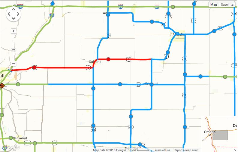
511ia.org IA DOT road conditions map (as of 5:58-a.m. Tue., 2/3/15)
The major arterial’s (Interstate 80, 680 and 29) are in normal driving condition this morning, while the secondary roads around western Iowa are partially covered with a mixture of ice/snow/slush.
Iowa’s weather during January featured several extremes. State climatologist Harry Hillaker says there were radical shifts in temperature, for starters, and despite the heavy snow that blanketed much of the state over the weekend, Iowa ended up lacking for precipitation during the month. “Very cold, generally speaking, for the first half of January, very mild and rather dry for the second half other than the big storm that came into the state on the very last day of January,” Hillaker says. “If we look at the state as a whole, the month ended up being about 2.3 degrees warmer than normal.”
In Atlantic, our average high for the month was 36. The average Low was 13. The normal High is 29, while the normal Low is 9. Most of Iowa got whalloped by a monster winter storm over the weekend that dumped up to 14-inches of snow on some areas of the state. Still, February 1st was Sunday, so the statewide average for precipitation during January was only about half-an-inch, which is about half the norm for the month.
“That basically does not include that event on the last day of the month,” Hillaker says. “For most of the official weather observers, their last report for the month would have come at 7 AM on January 31st, and all of that snow we had for the weekend came after that time, so it’ll end up in February’s records.”
In Atlantic, prior to the snow storm, we had received just 17 one-hundredths (.17”) of an inch of precipitation in January, from melted snowfall. Including snowfall for the 24-hour period that covered the 31st thru 7-a.m. Sunday, we received a total of .78” (78 one-hundredths of an inch) precipitation. Normal precipitation for the month is .84”
Hillaker says Iowa’s high and low temperatures for January were more than 90 degrees apart.
“Cherokee had the lowest temperature of the month, down to minus 24 degrees,” Hillaker says. “Then, toward the tail end of the month, right before the big snow event, we did have an impressive -for January- high of 67 degrees down in Shenandoah on the 28th day of the month.”
The lowest temp for the month in Atlantic, was -10 on the 12th and 13th of January. The warmest day was 59 degrees on the 16th. February started off much colder than normal and, for most of the state, much snowier than usual, too. Temperatures will likely stay below freezing this week and he says there will only be a little melting of the mounds of snow.
(Radio Iowa/KJAN weather records)
345 AM CST TUE FEB 3 2015
EARLY THIS MORNING…PARTLY CLOUDY. NORTHWEST WIND NEAR 5 MPH.
TODAY...MOSTLY CLOUDY. WARMER. HIGH IN THE UPPER 20S. SOUTH WIND NEAR 5 MPH INCREASING TO 10 TO 15 MPH IN THE AFTERNOON.
TONIGHT…MOSTLY CLOUDY. A 50 PERCENT CHANCE OF LIGHT SNOW EARLY IN THE MORNING. LOW 10 TO 15. NORTH WIND 5 TO 10 MPH.
WEDNESDAY…CLOUDY WITH SNOW LIKELY IN THE MORNING…THEN PARTLY SUNNY WITH A CHANCE OF SNOW IN THE AFTERNOON. SNOW ACCUMULATION OF 1 TO 2 INCHES. HIGH IN THE LOWER 20S. NORTH WIND 10 TO 15 MPH WITH GUSTS TO AROUND 25 MPH. CHANCE OF SNOW 70 PERCENT.
WEDNESDAY NIGHT…MOSTLY CLEAR. MUCH COLDER. LOW 5 TO 10 BELOW. WEST WIND NEAR 10 MPH. WIND CHILL READINGS AROUND 15 BELOW.
THURSDAY…SUNNY. HIGH 15 TO 20. SOUTH WIND 5 TO 10 MPH INCREASING TO AROUND 15 MPH IN THE AFTERNOON. GUSTS UP TO 25 MPH. LOWEST WIND CHILL READINGS 15 TO 20 BELOW IN THE MORNING.
FRIDAY…PARTLY SUNNY. MUCH WARMER. HIGH AROUND 40.
Snowblowers are droning and shovels are scraping concrete as most Iowans are digging out from a weekend that brought heavy snow to much of the state. Winter Storm Warnings were issued from Saturday afternoon into Sunday night as the steady rain changed to heavy snow. Meteorologist Brad Small, at the National Weather Service in Johnston, says virtually all of Iowa got at least some snow and many cities got more than a foot.
“Really, the worst-hit areas were from southwest Iowa through the northern Des Moines metro area,” Small says. “We had, here at the office, 14.2 inches and amounts from 8-to-13 inches were pretty common…through the Cedar Rapids area to just north of the Quad Cities. There’s about a third of the state saw better than ten inches.”
Many churches across the state cancelled worship services on Sunday and some flights were cancelled at Des Moines International Airport, while today (Monday), schools in Cedar Rapids, Iowa City, Dubuque and other districts have canceled classes and Mason City and Ames, among others, started late. Meteorologist Jim Lee, at the National Weather Service, says the most remarkable aspect of the storm was the precipitation amounts. Lee says, “When you took the total of the rain and melted snow, some areas got more precipitation in 24 hours than they normally see in the entire month of January.”
A week ago, a warm-up washed over Iowa and brought high temperatures in the 50s and 60s to many areas. That’s long gone, though, and Lee says this snow will be sticking around for a while. “The first chance to even get above freezing in most areas is around Friday and that won’t be by much,” Lee says. “So, we may see just a little bit of melting and certainly some compaction but no significant warmups or melting on the horizon.”
Highways in southwestern, central and eastern Iowa are still covered with snow according to Iowa Department of Transportation road conditions website. A 48-mile stretch of Highway 6 in southwest Iowa, between Council Bluffs and Griswold, was declared “impassible” due to drifting and blowing snow bringing white-out conditions.
(Radio Iowa)
The Freese-Notis weather forecast for the KJAN listening area, and weather information for Atlantic.
Podcast: Play in new window | Download (1.1MB)
Subscribe: RSS
345 AM CST MON FEB 2 2015
EARLY THIS MORNING…MOSTLY CLEAR. BITTERLY COLD. NORTHWEST WIND 5 TO 15 MPH. WIND CHILL READINGS AROUND 15 BELOW.
TODAY…MOSTLY SUNNY. VERY COLD. HIGH 15 TO 20. WEST WIND NEAR 5 MPH INCREASING TO SOUTH 10 TO 15 MPH IN THE AFTERNOON.
TONIGHT…MOSTLY CLOUDY THROUGH MIDNIGHT THEN BECOMING PARTLY CLOUDY. NOT AS COLD. LOW 5 TO 10 ABOVE. SOUTHWEST WIND 5 TO 10 MPH.
TUESDAY…PARTLY SUNNY. A 20 PERCENT CHANCE OF LIGHT SNOW IN THE AFTERNOON. WARMER. HIGH IN THE UPPER 20S. WEST WIND NEAR 5 MPH SHIFTING TO THE SOUTHEAST IN THE AFTERNOON.
WEDNESDAY…CLOUDY WITH A 50 PERCENT CHANCE OF SNOW. HIGH 15 TO 20. NORTH WIND AROUND 15 MPH WITH GUSTS TO AROUND 25 MPH.
THURSDAY…SUNNY. HIGH 15 TO 20.
Unofficial snowfall amounts reported to the National Weather Service in Des Moines for the snowstorm that occurred Saturday and Sunday, include the following:
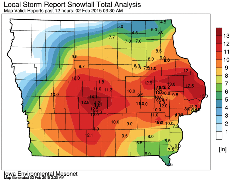
Snowfall report graphic from the NWS
URGENT - WINTER WEATHER MESSAGE
NATIONAL WEATHER SERVICE DES MOINES IA
908 PM CST SUN FEB 1 2015

.COLD AIR IS FILTERING INTO IOWA IN THE WAKE OF THE WINTER STORM.
HIGH PRESSURE OVER THE DAKOTAS WILL MOVE INTO NORTHWEST IOWA
TONIGHT.
SAC-CRAWFORD-CARROLL-GREENE-

...WIND CHILL ADVISORY REMAINS IN EFFECT FROM 3 AM TO 9 AM CST
MONDAY...

* TEMPERATURES/WIND CHILL VALUES...TEMPERATURES WILL FALL INTO THE
  5 TO 10 BELOW ZERO RANGE TONIGHT. WIND CHILL VALUES WILL FALL TO
  20 TO 25 DEGREES BELOW ZERO.

* WINDS...NORTHWEST WINDS...GUSTY AT TIMES...WILL DIMINISH
  OVERNIGHT TO 8 TO 15 MPH BY SUNRISE.

* IMPACTS...ROADS AND TRAVEL WILL REMAIN HAZARDOUS DUE TO THE
  SNOWFALL OF THE PAST 24 HOURS. SOME BLOWING AND DRIFTING SNOW
  CAN BE EXPECTED UNTIL AFTER MIDNIGHT.

PRECAUTIONARY/PREPAREDNESS ACTIONS...

A WIND CHILL ADVISORY MEANS THAT VERY COLD AIR AND STRONG WINDS
WILL COMBINE TO GENERATE LOW WIND CHILLS. THIS WILL RESULT IN
FROST BITE AND LEAD TO HYPOTHERMIA IF PRECAUTIONS ARE NOT TAKEN.
IF YOU MUST VENTURE OUTDOORS...MAKE SURE YOU WEAR A HAT AND
GLOVES.
AREA COUNTIES: MONONA-HARRISON-SHELBY-POTTAWATTAMIE-MONTGOMERY-PAGE– 547 PM CST SUN FEB 1 2015
...WINTER WEATHER ADVISORY IN EFFECT UNTIL 9 PM CST THIS EVENING…
…WINTER STORM WARNING IS CANCELLED...
THE NATIONAL WEATHER SERVICE IN OMAHA/VALLEY HAS ISSUED A WINTER WEATHER ADVISORY FOR BLOWING SNOW…WHICH IS IN EFFECT UNTIL 9 PM CST THIS EVENING. THE WINTER STORM WARNING HAS BEEN CANCELLED.
* TIMING…BLOWING SNOW WILL CONTINUE EARLY THIS EVENING THEN WILL END BY 9 PM AS WINDS DIMINISH.
* MAIN IMPACT…ROADS ARE SNOW COVERED…ICY AND HAZARDOUS. THE BLOWING SNOW WILL CONTINUE TO REDUCE VISIBILITY THIS EVENING…ESPECIALLY IN OPEN AND RURAL AREAS.
* OTHER IMPACTS…THE COLD COMBINED WITH THE WIND WILL CREATE WIND CHILLS 10 TO 20 BELOW ZERO.
PRECAUTIONARY/PREPAREDNESS ACTIONS…
A WINTER WEATHER ADVISORY FOR BLOWING SNOW MEANS THAT VISIBILITIES WILL BE LIMITED DUE TO STRONG WINDS BLOWING SNOW AROUND. USE CAUTION WHEN TRAVELING…ESPECIALLY IN OPEN AREAS.


