
ADAIR-MADISON-UNION-RINGGOLD COUNTIES….406 AM CDT TUE APR 7 2015
…AREAS OF DENSE FOG EARLY THIS MORNING…
DENSE FOG CONTINUES OVER PORTIONS OF SOUTHERN IOWA. VISIBILITY IS AT OR JUST BELOW ONE QUARTER MILE AND THIS WILL CONTINUE DURING THE MORNING COMMUTE. AREA TRAVELERS SHOULD USE LOW BEAM HEADLIGHTS…ALLOW EXTRA TIME TO REACH YOUR DESTINATION SAFELY AND ALLOW EXTRA DISTANCE BETWEEN YOU AND VEHICLES AHEAD OF YOU.
ALSO…BE MINDFUL WHEN APPROACHING INTERSECTIONS AND RAILROAD CROSSINGS AS APPROACHING VEHICLES AND TRAINS MAY BE HIDDEN BY THE FOG. ALSO BE CAREFUL NEAR BUS STOPS AND SCHOOLS.
401 AM CDT TUE APR 7 2015
EARLY THIS MORNING…CLOUDY WITH A CHANCE OF LIGHT SHOWERS WITH POSSIBLE THUNDERSTORMS AND DRIZZLE. AREAS OF FOG. NORTHEAST WIND 5 TO 10 MPH. CHANCE OF PRECIPITATION 20 PERCENT.
TODAY…CLOUDY. AREAS OF FOG IN THE MORNING. A CHANCE OF SHOWERS AND ISOLATED THUNDERSTORMS THROUGH MID MORNING. SCATTERED THUNDERSTORMS IN THE LATE MORNING AND EARLY AFTERNOON…THEN A SLIGHT CHANCE OF SHOWERS AND ISOLATED THUNDERSTORMS LATE IN THE AFTERNOON. HIGH IN THE LOWER 60S. EAST WIND 10 TO 15 MPH WITH GUSTS TO AROUND 25 MPH. CHANCE OF PRECIPITATION 50 PERCENT.
TONIGHT…CLOUDY. A SLIGHT CHANCE OF SHOWERS AND ISOLATED THUNDERSTORMS IN THE EVENING. LOW IN THE LOWER 40S. NORTH WIND 5 TO 15 MPH. CHANCE OF PRECIPITATION 20 PERCENT.
WEDNESDAY…CLOUDY. A CHANCE OF THUNDERSTORMS IN THE MORNING. PATCHY DRIZZLE THROUGH THE DAY. THUNDERSTORMS LIKELY IN THE AFTERNOON. HIGH IN THE UPPER 50S. EAST WIND 5 TO 15 MPH. CHANCE OF THUNDERSTORMS 70 PERCENT.
WEDNESDAY NIGHT…THUNDERSTORMS LIKELY. LOW AROUND 50. CHANCE OF THUNDERSTORMS 70 PERCENT.
THURSDAY…MOSTLY CLOUDY. A CHANCE OF SHOWERS AND ISOLATED THUNDERSTORMS IN THE MORNING…THEN A SLIGHT CHANCE OF SHOWERS AND ISOLATED THUNDERSTORMS IN THE AFTERNOON. BREEZY. HIGH IN THE LOWER 60S. SOUTHWEST WIND NEAR 10 MPH INCREASING TO WEST 15 TO 20 MPH WITH GUSTS TO AROUND 30 MPH IN THE AFTERNOON. CHANCE OF PRECIPITATION 40 PERCENT.
FRIDAY…MOSTLY SUNNY. HIGH IN THE LOWER 60S.
DES MOINES, Iowa (AP) — Drought conditions are expanding across a large section of the U.S., from California to the Great Plains. The National Drought Mitigation Center at the University of Nebraska says the area covered by moderate drought or worse expanded by nearly five percentage points to 36.8 percent during March.
The drought monitor shows dry conditions broadened in the Midwest with 22 percent of the U.S. corn production area and 18 percent of the soybean area in some degree of drought. That’s up sharply from early March when just 6 percent of the corn growing area and 5 percent of the soybean region were in drought conditions.
Dryness worsened during March in Colorado, Kansas, Minnesota, Nebraska, North Dakota, South Dakota and Wisconsin. Two-thirds of California is in extreme to exceptional drought.
The Freese-Notis forecast and weather information for Atlantic.
Podcast: Play in new window | Download (1.1MB)
Subscribe: RSS
THIS HAZARDOUS WEATHER OUTLOOK IS FOR PORTIONS OF CENTRAL and WESTERN IOWA.
TODAY AND TONIGHT: ISOLATED NON SEVERE THUNDERSTORMS WILL BE POSSIBLE THIS AFTERNOON THROUGH MIDNIGHT. THUNDERSTORM COVERAGE WILL INCREASE TOWARD MORNING. A FEW STORMS MAY BE SEVERE TONIGHT WITH LARGE HAIL BEING THE MAIN THREAT.
TUESDAY THROUGH SUNDAY: SCATTERED THUNDERSTORMS ARE EXPECTED TUESDAY. THERE WILL BE THE POTENTIAL FOR A FEW SEVERE THUNDERSTORMS WITH HAIL OR WIND THE MAIN THREATS.
ADDITIONAL ROUNDS OF THUNDERSTORMS ARE EXPECTED WEDNESDAY NIGHT
THROUGH THURSDAY AFTERNOON. A MORE ORGANIZED THREAT FOR SEVERE
WEATHER IS EXPECTED. AT THIS TIME…LARGE HAIL AND DAMAGING
THUNDERSTORM WINDS WILL BE THE MAIN THREATS. ISOLATED TORNADOES
MAY ALSO OCCUR…THOUGH IT IS TOO EARLY TO DETERMINE THE AREA OF
GREATEST THREAT.
411 AM CDT MON APR 6 2015
EARLY THIS MORNING…MOSTLY CLOUDY. SOUTH WIND 10 TO 15 MPH WITH GUSTS TO AROUND 25 MPH.
TODAY...CLOUDY. SCATTERED LIGHT SHOWERS AND PATCHY DRIZZLE THROUGH THE DAY. ISOLATED THUNDERSTORMS IN THE AFTERNOON. HIGH IN THE LOWER 60S. SOUTHEAST WIND 10 TO 15 MPH. CHANCE OF PRECIPITATION 50 PERCENT.
TONIGHT…MOSTLY CLOUDY. A CHANCE OF LIGHT SHOWERS AND ISOLATED THUNDERSTORMS THROUGH MIDNIGHT…THEN A CHANCE OF THUNDERSTORMS AFTER MIDNIGHT. LOW IN THE LOWER 50S. EAST WIND 5 TO 10 MPH. CHANCE OF PRECIPITATION 50 PERCENT.
TUESDAY…MOSTLY CLOUDY. A CHANCE OF THUNDERSTORMS THROUGH MID MORNING…THEN SCATTERED THUNDERSTORMS AND A CHANCE OF RAIN IN THE LATE MORNING AND AFTERNOON. HIGH IN THE LOWER 60S. NORTHEAST WIND 10 TO 15 MPH. CHANCE OF PRECIPITATION 50 PERCENT.
TUESDAY NIGHT...MOSTLY CLOUDY. PATCHY DRIZZLE THROUGH MIDNIGHT. PATCHY FOG AFTER MIDNIGHT. LOW IN THE MID 40S. NORTHEAST WIND 10 TO 15 MPH.
WEDNESDAY…CLOUDY WITH A 50 PERCENT CHANCE OF THUNDERSTORMS. HIGH IN THE UPPER 50S. EAST WIND 10 TO 15 MPH. GUSTS UP TO 25 MPH IN THE AFTERNOON.
WEDNESDAY NIGHT…THUNDERSTORMS THROUGH MIDNIGHT…THEN THUNDERSTORMS LIKELY AFTER MIDNIGHT. LOW IN THE LOWER 50S. CHANCE OF THUNDERSTORMS 80 PERCENT.
THURSDAY…THUNDERSTORMS AND RAIN LIKELY. WARMER. HIGH IN THE UPPER 60S. CHANCE OF PRECIPITATION 70 PERCENT.
Today: Sunny & breezy, with a high near 70. South wind 15 to 20 mph, with gusts to near 30 mph. Tonight: Mostly cloudy & breezy, with a low around 47. South wind 10- to 20 mph, with gusts as high as 25 mph.
Monday: Cloudy with a 30% chance of showers and thunderstorms. High near 67. South southeast wind 10 to 15 mph. New rainfall amounts of less than a tenth of an inch, except higher amounts possible in thunderstorms.
Monday Night: Cloudy with a 50% chance of showers and thunderstorms. Low around 48. New rainfall amounts between a tenth and quarter of an inch, except higher amounts possible in thunderstorms.
Tuesday: Mostly Cloudy & breezy, w/a 50% chance of showers and thunderstorms. High near 60. N/NE wind 10 to 20 mph, with gusts as high as 25 mph. New rainfall amounts between a tenth and quarter of an inch, except higher amounts possible in thunderstorms.
Wednesday: Mostly cloudy & breezy, w/a 40% chance of showers and thunderstorms. High near 59.
The National Weather Service forecast for Atlantic and the KJAN listening area, and weather information for Atlantic.
Podcast: Play in new window | Download (1,001.3KB)
Subscribe: RSS
Iowans should be able to get a good view of a total lunar eclipse early this (Saturday) morning. Linda Burkhart is director of the Sanford Museum and Planetarium in Cherokee. She says the attraction is commonly referred to as a blood moon.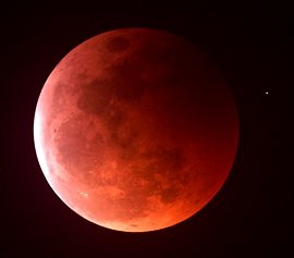 “A lunar eclipse is caused by the shadow of the earth going across the moon. The sunlight will still come through that shadow and will reflect the light, so only the red-orange colored light rays will get through the atmosphere, so it’ll make the moon appear a reddish color,” Burkhart says.
This morning’s lunar eclipse should begin around 5:15 a.m., with the total eclipse lasting for just five minutes at around 7 a.m.
(Radio Iowa)
UPDATED 355 AM CDT SAT APR 4 2015
EARLY THIS MORNING…MOSTLY CLEAR. SOUTHWEST WIND 5 TO 10 MPH.
TODAY…SUNNY…BREEZY…WARMER. HIGH IN THE UPPER 60S. SOUTHWEST WIND 10 TO 20 MPH WITH GUSTS TO AROUND 30 MPH.
TONIGHT…PARTLY CLOUDY. BREEZY. NOT AS COOL. LOW IN THE LOWER 40S. SOUTH WIND 15 TO 20 MPH WITH GUSTS TO AROUND 30 MPH.
SUNDAY…MOSTLY SUNNY. BREEZY. HIGH IN THE LOWER 70S. SOUTHWEST WIND 15 TO 20 MPH.
SUNDAY NIGHT…PARTLY CLOUDY. LOW IN THE UPPER 40S. SOUTH WIND 10 TO 15 MPH.
MONDAY…CLOUDY. A CHANCE OF SHOWERS AND ISOLATED THUNDERSTORMS. SOME THUNDERSTORMS MAY BE SEVERE IN THE MORNING. HIGH IN THE UPPER 60S. EAST WIND 10 TO 15 MPH. CHANCE OF PRECIPITATION 50 PERCENT.
MONDAY NIGHT…CLOUDY WITH SCATTERED THUNDERSTORMS. LOW IN THE MID 40S. CHANCE OF THUNDERSTORMS 50 PERCENT.
TUESDAY…CLOUDY WITH SCATTERED THUNDERSTORMS. COOLER. HIGH IN THE MID 50S. CHANCE OF THUNDERSTORMS 50 PERCENT.


