
(Updated 6:45-a.m./NWS Des Moines)
Today: Sunny…warmer. High in the lower 60s. East wind 5 to 15 mph.
Tonight: Clear. Low in the upper 30s. Northeast wind 5 to 10 mph.
Monday: Sunny. High in the mid 60s. Northeast wind 5 to 10 mph.
Monday Night: Mostly clear. Low in the upper 30s. Northeast wind near 10 mph.
Tuesday: Sunny. High around 70. North wind near 10 mph.
Tuesday Night: Partly cloudy. Low in the mid 40s.
Wednesday: Sunny. High in the upper 60s.
Thursday: Sunny. High in the lower 70s.
Today: Showers and thunderstorms before 1pm, then scattered showers. High near 52. Breezy, with a northeast wind 15 to 17 mph, with gusts as high as 26 mph. Chance of precipitation is 100%. New rainfall amounts between a tenth and quarter of an inch, except higher amounts possible in thunderstorms.
Tonight: Isolated showers before 7pm. Mostly cloudy, with a low around 39. Northeast wind 8 to 14 mph. Chance of precipitation is 10%.
Sunday: Sunny, with a high near 61. East northeast wind 9 to 15 mph, with gusts as high as 21 mph.
Sunday Night: Clear, with a low around 37. East northeast wind 6 to 10 mph.
Monday: Sunny, with a high near 64. Northeast wind 6 to 10 mph.
Tuesday: Sunny, with a high near 67.
Podcast: Play in new window | Download (394.6KB)
Subscribe: RSS
The Freese-Notis forecast for the KJAN listening area and weather info. for Atlantic.
Podcast: Play in new window | Download (1.1MB)
Subscribe: RSS
EARLY THIS MORNING…CLOUDY WITH ISOLATED THUNDERSTORMS. WARMER. SOUTHEAST WIND 10 TO 15 MPH WITH GUSTS TO AROUND 25 MPH. CHANCE OF THUNDERSTORMS 20 PERCENT.
TODAY…CLOUDY. NUMEROUS SHOWERS AND ISOLATED THUNDERSTORMS THROUGH THE DAY. HIGH IN THE UPPER 50S. SOUTHEAST WIND 10 TO 15 MPH WITH GUSTS TO AROUND 25 MPH. CHANCE OF PRECIPITATION 70 PERCENT.
TONIGHT…NUMEROUS SHOWERS AND ISOLATED THUNDERSTORMS IN THE EVENING…THEN LIGHT SHOWERS AND ISOLATED THUNDERSTORMS OVERNIGHT. LOW IN THE UPPER 40S. EAST WIND 10 TO 15 MPH. CHANCE OF PRECIPITATION 90 PERCENT.
SATURDAY…LIGHT SHOWERS LIKELY UNTIL LATE AFTERNOON…THEN A CHANCE OF LIGHT SHOWERS LATE IN THE AFTERNOON. HIGH IN THE LOWER 50S. NORTHEAST WIND 10 TO 15 MPH WITH GUSTS TO AROUND 25 MPH. CHANCE OF SHOWERS 70 PERCENT.
SATURDAY NIGHT…MOSTLY CLOUDY. COLDER. LOW IN THE UPPER 30S. NORTHEAST WIND 10 TO 15 MPH. GUSTS UP TO 25 MPH THROUGH MIDNIGHT.
SUNDAY…MOSTLY SUNNY. HIGH AROUND 60. EAST WIND 10 TO 15 MPH.
MONDAY…SUNNY. HIGH IN THE LOWER 60S.
The Iowa Department of Natural Resources says the past two weeks have seen needed rainfall over much of the state, ending a very dry stretch of weather. The rains reflect improvements to the drought, streamflow and shallow groundwater conditions.
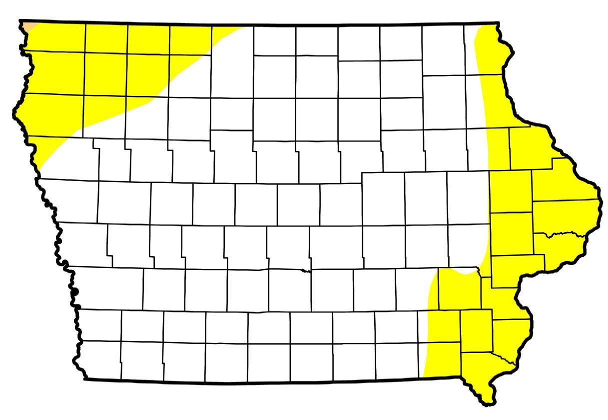
Areas in yellow are experiencing “Abnormally Dry” conditions. Areas in white are considered to have “Normal” soil conditions as of April 21st.
Rainfall totals varied from just over seven-tenths (0.70) inches at Muscatine to more than six-inches inches at Lake Mills. In Atlantic, rainfall from April 7th through this past Tuesday, amounted to 2.39-inches, which matches the statewide average. Temperatures have averaged 4.5 degrees above normal, as well. Officials say the wet weather comes at a time when Iowa is entering its traditionally wet months, and is a positive sign for conditions through spring.
The area of the state classified as abnormally dry has dropped from 50 percent to 25 percent according to the National Drought Monitor, a significant improvement over one year ago when more than 75 percent of the state was abnormally dry. Slight drought conditions remain present in far northwest and eastern Iowa.
For a thorough review of Iowa’s water resource trends, go to www.iowadnr.gov/watersummaryupdate. The report is prepared by the technical staff from the Iowa DNR, the Iowa Department of Agriculture and Land Stewardship, IIHR—Hydroscience and Engineering and the U.S. Geological Survey, in collaboration with The Iowa Homeland Security and Emergency Management Department.
The Freese-Notis forecast for the KJAN listening area and weather info. for Atlantic.
Podcast: Play in new window | Download (895.4KB)
Subscribe: RSS
CASS-ADAIR-MADISON–ADAMS-UNION- TAYLOR-RINGGOLD COUNTIES…425 AM CDT THU APR 23 2015
…FREEZE WARNING REMAINS IN EFFECT UNTIL 8 AM CDT THIS MORNING…
* TIMING…THROUGH THE EARLY MORNING HOURS.
* TEMPERATURE…TEMPERATURES WILL FALL TO THE MID 20S TO AROUND 30 DEGREES BY SUNRISE. THEY WILL RISE RAPIDLY AFTER 7 AM.
* IMPACTS…SENSITIVE VEGETATION MAY BE AFFECTED BY THE FREEZING
TEMPERATURES.
PRECAUTIONARY/PREPAREDNESS ACTIONS…
A FREEZE WARNING MEANS SUB-FREEZING TEMPERATURES ARE IMMINENT OR HIGHLY LIKELY. THESE CONDITIONS WILL KILL SENSITIVE VEGETATION.
**Freeze Warning in effect until 8-a.m. for Cass, Adair, Adams, Madision, Ringgold, Taylor & Union Counties**
Today: Patchy frost before 8am. Otherwise, sunny, with a high near 61. Light and variable wind becoming south 5 to 8 mph in the morning.
Tonight: A 30 percent chance of showers and thunderstorms, mainly after 4am. Increasing clouds, with a low around 46. South southeast wind 9 to 13 mph. New rainfall amounts of less than a tenth of an inch, except higher amounts possible in thunderstorms.
Friday: A chance of showers and thunderstorms before 7am, then showers likely and possibly a thunderstorm between 7am and 1pm, then a chance of showers and thunderstorms after 1pm. Cloudy, with a high near 55. Breezy, with a southeast wind 14 to 16 mph, with gusts as high as 23 mph. Chance of precipitation is 60%. New rainfall amounts between a tenth and quarter of an inch, except higher amounts possible in thunderstorms.
Friday Night: Showers likely, with thunderstorms also possible after 1am. Cloudy, with a low around 47. East southeast wind 8 to 14 mph, with gusts as high as 20 mph. Chance of precipitation is 70%. New rainfall amounts between a quarter and half of an inch possible.
Saturday: A chance of showers, mainly before 1pm. Cloudy, with a high near 54. North northeast wind 9 to 14 mph, with gusts as high as 20 mph. Chance of precipitation is 30%. New rainfall amounts between a tenth and quarter of an inch possible.
Sunday: Mostly sunny, with a high near 59.
COUNTIES: SAC-CRAWFORD-CARROLL-AUDUBON-GUTHRIE-DALLAS-CASS-ADAIR-MADISON-ADAMS-UNION-TAYLOR-RINGGOLD…-
323 PM CDT WED APR 22 2015
Freeze Warning for Counties in purple
…FREEZE WARNING IN EFFECT FROM 2 AM TO 8 AM CDT THURSDAY…
THE NATIONAL WEATHER SERVICE IN DES MOINES HAS ISSUED A FREEZE WARNING…WHICH IS IN EFFECT FROM 2 AM TO 8 AM CDT THURSDAY.
* TIMING…LATE TONIGHT INTO EARLY THURSDAY MORNING.
* TEMPERATURE…TEMPERATURES WILL FALL TO THE MID 20S TO AROUND 30 DEGREES BY EARLY THURSDAY MORNING.
* IMPACTS…SENSITIVE VEGETATION MAY BE AFFECTED BY THE FREEZING
TEMPERATURES.
PRECAUTIONARY/PREPAREDNESS ACTIONS…
A FREEZE WARNING MEANS SUB-FREEZING TEMPERATURES ARE IMMINENT OR
HIGHLY LIKELY. THESE CONDITIONS WILL KILL CROPS AND OTHER
SENSITIVE VEGETATION.
The Freese-Notis forecast for the KJAN listening area and weather info. for Atlantic.
Podcast: Play in new window | Download (1.0MB)
Subscribe: RSS


