
(Update 8:32-a.m. Aftershock felt just before 8-a.m. 9.3 miles NW of Pawnee, OK, 3.6 magnitude, about 1.1 miles deep)
CHICAGO (AP) – An earthquake has rattled a swath of the Great Plains, from Iowa and Nebraska to as far south as northern Texas. The temblor shockwave was felt in Atlantic, Brayton, Des Moines and Omaha at around 7:05-a.m.. KJAN received several phone calls from residents saying their lights were swaying and they felt a rumble. The United States Geological Survey (USGS) said the quake happened at 7:02-a.m., and measured 5.6 on the Richter Scale and was centered about 8.5-miles northwest of Pawnee, Oklahoma. It occurred at a depth of about 4-miles, or very shallow by most standards. It also tweeted that aftershocks may occur. (One aftershock felt just before 8-a.m. 9.3 miles NW of Pawnee, OK, 3.6 magnitude, about 1.1 miles deep)
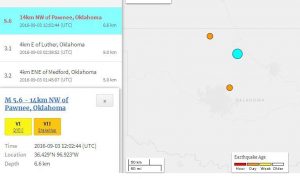
The light blue dot on the map is the epicenter of the initial quake that happened at 7:02-a.m. CDT 9/3/16
Sean Weide in Omaha, Nebraska, said he’d never been in an earthquake before and thought he was getting dizzy. Weide said he and one of his daughters “heard the building start creaking” and said it “was surreal.” People in Kansas City, Missouri; Fayetteville, Arkansas; and Norman, Oklahoma, all reported feeling the earthquake. Dallas TV station WFAA tweeted that it felt the quake, too.
Today: Mostly sunny, with a high near 77. South wind 6 to 13 mph, with gusts as high as 18 mph.
Tonight: Partly cloudy, with a low around 61. South southeast wind 7 to 10 mph.
Sunday: Partly sunny, with a high near 82. Breezy, with a south southeast wind 9 to 18 mph, with gusts as high as 26 mph.
Sunday Night: A 20 percent chance of showers and thunderstorms. Mostly cloudy, with a low around 68. Breezy, with a south southeast wind 14 to 16 mph, with gusts as high as 23 mph.
Labor Day: Mostly sunny, with a high near 87. Windy, with a south wind 14 to 21 mph, with gusts as high as 29 mph.
Monday Night: A 20 percent chance of showers and thunderstorms. Partly cloudy, with a low around 72. Breezy.
Tuesday: A 40 percent chance of showers and thunderstorms. Partly sunny, with a high near 88.
More than 80 percent of the state’s corn and soybean fields were rated in “good” or “excellent” condition at the start of this week and one weather experts says the 2016 growing season “has turned out pretty well” for Iowa farmers. State Climatologist Harry Hillaker says crop development is about a week to a week-and-a-half ahead of normal. “Things for the most part got planted on a timely basis, with exceptions in far western Iowa that had a pretty mid-April and early May, but otherwise in much of the state things got planted on time. It’s been a relatively warm growing season, so things that did get planted on time have been progressing along very well.”
Yield prospects are “looking quite good” for most of the state, according to Hillaker. “A few places still a bit on the dry side, but nothing really super dry at this point,” Hillaker says. “Certainly northwest Iowa could use some rain, although it’s getting late enough in the growing season that it may still, perhaps, help out the soybean, but probably too late to have any benefit for the corn crop in that part of the state.”
A small area stretching from Onawa to just northwest of Sac City got NO rainfall at all last week, while nearly nine inches fell near Decorah. About nine-tenths of an inch is the normal amount of rainfall in Iowa for the final week of August.
(Radio Iowa)
Today: Areas of fog this morning; Mo. Sunny. High 78. NE @ 10-15.
Tonight: Mo. Clear. Low around 55.
Tomorrow: Partly Cloudy. High near 80 SE @ 10-15.
Sunday: P/Cldy w/isolated showers possible. High 83.
Monday: P/Cldy w/isolated shwrs & tstrms. High 87.
Thursday’s High in Atlantic was 80. Our 24-hour Low was 52. Last year on this date, our High in Atlantic was 86 and the low was 70. The Record High in Atlantic on this date was 101 in 2000. The Record Low was 30 in 1983.
322 AM CDT FRI SEP 2 2016
EARLY THIS MORNING…MOSTLY CLEAR. EAST WIND 5 TO 10 MPH.
TODAY…SUNNY. HIGH IN THE MID 70S. SOUTHEAST WIND 5 TO 10 MPH.
TONIGHT…MOSTLY CLEAR. LOW IN THE MID 50S. SOUTHEAST WIND 5 TO 10 MPH.
SATURDAY…MOSTLY SUNNY. HIGH IN THE UPPER 70S. SOUTH WIND 5 TO 10 MPH.
SATURDAY NIGHT…PARTLY CLOUDY THROUGH MIDNIGHT…THEN MOSTLY CLOUDY WITH A 20 PERCENT CHANCE OF THUNDERSTORMS AFTER MIDNIGHT. LOW IN THE LOWER 60S. SOUTHEAST WIND 5 TO 10 MPH.
SUNDAY…PARTLY SUNNY WITH A 20 PERCENT CHANCE OF THUNDERSTORMS. BREEZY. HIGH IN THE LOWER 80S. SOUTH WIND 5 TO 15 MPH INCREASING TO 15 TO 20 MPH IN THE AFTERNOON.
SUNDAY NIGHT…PARTLY CLOUDY WITH A 20 PERCENT CHANCE OF THUNDERSTORMS. BREEZY. LOW IN THE UPPER 60S.
LABOR DAY…MOSTLY SUNNY. HIGH IN THE UPPER 80S.
The month of August was nearly normal in Atlantic, with regard to temperatures, but a little wetter, than average. Here at the KJAN Studios, we received 4.39″ of rain last month, which was just over one-half inch more than normal (.51″). The average high was 84, while the average low was 61. The high was only .4″ of a degree warmer than normal, while the low was .6″ of a degree warmer than normal.
Today: Areas of fog this morning; Mo. Sunny. High 78. NE @ 10.
Tonight: Mo. Clear. Low around 53.
Tomorrow: Mo. Sunny. High near 78
Saturday: P/Cldy. High 82.
Sunday: P/Cldy w/isolated shwrs & tstrms. High 82.
Wednesday’s High in Atlantic was 81. Our 24-hour Low was 52. Last year on this date, our High in Atlantic was 87 and the low was 68. The Record High in Atlantic on this date was 99 in 1913. The Record Low was 34 in 1967.
344 AM CDT THU SEP 1 2016
EARLY THIS MORNING…CLEAR. NORTHEAST WIND NEAR 5 MPH.
TODAY…SUNNY. HIGH IN THE UPPER 70S. NORTHEAST WIND NEAR 10 MPH.
TONIGHT…MOSTLY CLEAR. LOW IN THE MID 50S. EAST WIND NEAR 10 MPH.
FRIDAY…SUNNY. HIGH IN THE UPPER 70S. SOUTHEAST WIND NEAR 10 MPH.
FRIDAY NIGHT…MOSTLY CLEAR. LOW IN THE MID 50S. SOUTHEAST WIND 5 TO 10 MPH.
SATURDAY…MOSTLY SUNNY. HIGH IN THE UPPER 70S. SOUTH WIND 5 TO 15 MPH.
SATURDAY NIGHT...MOSTLY CLOUDY WITH A 20 PERCENT CHANCE OF THUNDERSTORMS. LOW IN THE LOWER 60S.
SUNDAY…MOSTLY CLOUDY WITH A 30 PERCENT CHANCE OF THUNDERSTORMS. HIGH IN THE LOWER 80S.
Mostly clear skies are forecast as the 14th annual Iowa Star Party starts tomorrow (Thursday) night in west-central Iowa as sky gazers pack in their telescopes to gaze into the heavens. Deb Bonser, of the Ames Area Amateur Astronomers, is coordinating the annual event which draws in space-watching enthusiasts from all over the Midwest.
“On Friday night, we have a public night that is free to everybody who wants to come out,” Bonser says. “They get a chance to look through different kinds of telescopes and see different objects up in the sky and learn a lot about what’s up in the sky.”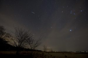 The Star Party is being held at the Whiterock Conservancy, southeast of Coon Rapids, and she says there’s an obvious reason. “It’s one of the darkest spots in Iowa,” Bonser says. “We’re not bothered by street lights, city lights that are lighting up the sky and we can see things much more clearly.”
If the skies remain cloud-free, there will be a chance to see numerous nebulas and stars millions of light years away, as well as some of the planets in our cosmic back yard. “I am going to be putting a camera on a tripod. I do Milky Way photography and I’m going to see if I can get a galaxy in one of my photos and see what I can get,” Bonser says. “It depends on the weather.”
The Star Party runs nightly for the serious astronomers, tonight through Monday night, while Friday’s open public viewing begins at 7:30 P-M and runs into the wee hours.
(Radio Iowa)
Today: Areas of fog possible this morning; Partly Cloudy. High 80. N @ 10.
Tonight: P/Cldy. Low around 55.
Tomorrow: P/Cldy. High near 78
Friday: P/Cldy. High 78.
Saturday: P/Cldy. High 82.
Tuesday’s High in Atlantic was 88. Our 24-hour Low (ending today at 7-a.m.) was 63. We received .01” of an inch rain Tuesday, here at KJAN. Last year on this date, our High in Atlantic was 84 and the low was 57. The Record High in Atlantic on this date was 101 in 1913. The Record Low was 35 in 1967.


