
328 AM CDT Sun Jun 30 2019 For all but the far west/southwest counties: A HEAT ADVISORY NOW IN EFFECT FROM 11 AM THIS MORNING TO 9 PM CDT THIS EVENING FOR CASS AND MOST OF THE KJAN LISTENING AREA…(previously it was set to go into effect at 1-p.m. today). For Monona-Harrison-Shelby-Pottawattamie-Mills-Montgomery-Fremont-Page Counties, the Advisory will begin at 1-p.m..
* TEMPERATURE…Highs in the low to mid 90s, with peak heat index values around 105 degrees.
* IMPACTS…Heat illnesses are possible for those active outdoors, in homes without air conditioning, or those susceptible to heat illnesses such as children and the elderly.
PRECAUTIONARY/PREPAREDNESS ACTIONS…
A Heat Advisory means that a period of hot temperatures is expected. The combination of hot temperatures and high humidity will combine to create a situation in which heat illnesses are possible. Drink plenty of fluids, stay in an air-conditioned
room, stay out of the sun, and check up on relatives and neighbors.
Take extra precautions, if you work or spend time outside. When possible, reschedule strenuous activities to early morning or evening. Know the signs and symptoms of heat exhaustion and heat stroke. Wear light weight and loose fitting clothing when
possible and drink plenty of water.
To reduce risk during outdoor work, the occupational safety and health administration recommends scheduling frequent rest breaks in shaded or air conditioned environments. Anyone overcome by heat should be moved to a cool and shaded location. Heat stroke is an emergency, call 9 1 1.
A Heat Advisory remains in effect until 9-p.m. for all but the eastern third of Iowa, today (Saturday). Another HEAT ADVISORY will be in effect Sunday for the same time frame (1-p.m. to 9-p.m.).
Highs will be in the lower-to mid-90’s Sunday, with peak heat index values of 103-to near 110 degrees.
Heat illnesses are possible for those active outdoors, in home without air conditioning, or those susceptible to heat illnesses, such as children and the elderly.
A Heat Advisory means that a period of hot temperatures is expected. The combination of hot temperatures and high humidity will combine to create a situation in which heat illnesses are possible. Drink plenty of fluids, stay in an air-conditioned
room, stay out of the sun, and check up on relatives and neighbors.
Take extra precautions, if you work or spend time outside. When possible, reschedule strenuous activities to early morning or evening. Know the signs and symptoms of heat exhaustion and heat stroke. Wear light weight and loose fitting clothing when
possible and drink plenty of water.
To reduce risk during outdoor work, the occupational safety and health administration recommends scheduling frequent rest breaks in shaded or air conditioned environments. Anyone overcome by heat should be moved to a cool and shaded location. Heat stroke is an emergency, call 9 1 1.
Today: **HEAT ADVISORY from 1-p.m. Until 9-p.m.** Areas of fog this morning; Partly cloudy. High 93. Heat Index around 102. S @ 10-15.
Tonight: P/Cldy. Low 73. S @ 5-10.
Tomorrow: P/Cldy. High near 93. S @ 10-15. Heat Index around 101.
Monday: P/Cldy w/isolated thundershowrs. High 90.
Tuesday: P/Cldy w/scattered thundershowers. High around 87.
Yesterday’s High in Atlantic was 89. Our Low this morning 71. Last year on this date our High was 92 and the Low was 75. The record High in Atlantic on this date was 102 in 1934. The Record Low was 46 in 1950.
THE NATIONAL WEATHER SERVICE HAS ISSUED A HEAT ADVISORY FOR MOST OF IOWA FROM 1-P.M. SATURDAY UNTIL 9-P.M., INCLUDING THE ENTIRE KJAN LISTENING AREA.
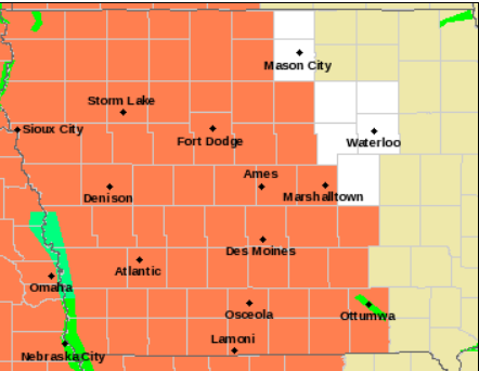
Heat Advisory for all counties in orange.
* TEMPERATURE…Highs should reach the lower 90s with peak afternoon heat indicies from the upper 90s to as high as 105 degrees.
* IMPACTS…Heat illnesses are possible for those active outdoors or those susceptible to heat illnesses such as children and the elderly.
PRECAUTIONARY/PREPAREDNESS ACTIONS…
A Heat Advisory means that a period of hot temperatures is expected. The combination of hot temperatures and high humidity will combine to create a situation in which heat illnesses are possible. Drink plenty of fluids, stay in an air-conditioned
room, stay out of the sun, and check up on relatives and neighbors.
Take extra precautions, if you work or spend time outside. When possible, reschedule strenuous activities to early morning or evening. Know the signs and symptoms of heat exhaustion and heat stroke. Wear light weight and loose fitting clothing when possible and drink plenty of water.
To reduce risk during outdoor work, the occupational safety and health administration recommends scheduling frequent rest breaks in shaded or air conditioned environments. Anyone overcome by heat should be moved to a cool and shaded location. Heat stroke is an emergency, call 9 1 1.
In an update to their previous report, the National Weather Service in Des Moines says the hottest weather of the year thus far will impact Iowa through the upcoming weekend. High temperatures will top out in the upper 80s to mid-90s each day, with overnight lows only in the 70s each night. Heat index values will approach 100°F each afternoon/evening, making this easily the hottest stretch of weather experienced since last summer. The hottest temps are likely in the western half of Iowa. A Heat Advisory is in effect for three counties in Northwest Iowa.
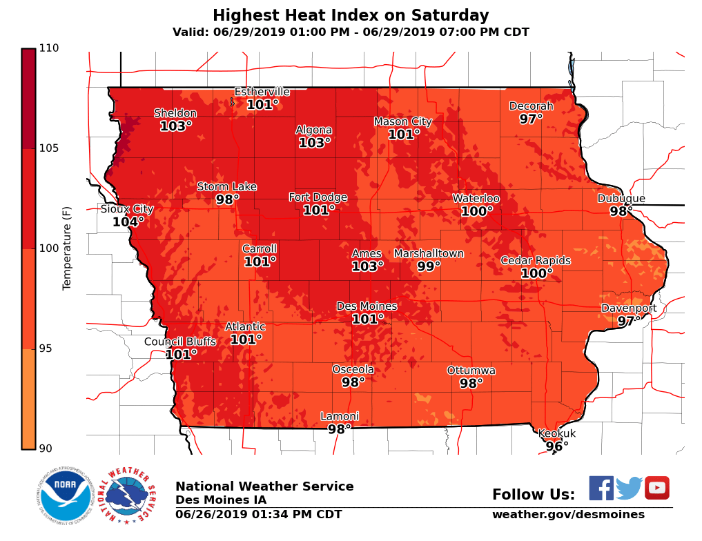
 The latest information puts the Heat Index (how it feels) in Atlantic, Council Bluffs and Sheldon at around 103 degrees, Sioux City 105, 101 in Carroll, Des Moines and Ft. Dodge, 102 in Algona and Ames, and 100 in Estherville. Other locations will have a heat index of 95-to 97-degrees. If planning outdoor activities, avoid prolonged exposure to the heat and be HEAT SMART.
Heat is the #1 weather-related killer in the United States! Here are a few tips on staying safe during episodes of dangerously hot weather:
For more information, check the National Weather Service’s Heat Safety page.
Today: Partly cloudy w/isolated showers & thunderstorms possible. High 91. Heat Index around 100.
S @ 10-20.
Tonight: P/Cldy. Low 74. S @ 5-10.
Tomorrow: P/Cldy. High near 93. S @ 10-20. Heat Index around 101.
Sunday: P/Cldy. High 93.
Monday: P/Cldy w/scattered thundershowers. High around 90.
Yesterday’s High in Atlantic was 89. Our Low was 73. Last year on this date our High was 85 and the Low was 64. The record High in Atlantic on this date was 103 in 1936. The Record Low was 50 in 1896 & 2006.
Get ready for the heat and humidity later this week into the upcoming weekend!! The National Weather Service in Des Moines says temperatures will warm from upper 80s today (Thursday) into the lower to middle 90s by this weekend. These temperatures combined with tropical humidity levels will result in heat index values rising into the 95°F to 105°F range! The Heat Index Saturday in Atlantic, Council Bluffs and Des Moines will be around 101 degrees, with Sioux City coming in at 104, and Ames at 103! Be HEAT SMART if you have outdoor plans late this week into the weekend.
Today: Partly cloudy. High around 90. S @ 10-15.
Tonight: P/Cldy w/isolated thundershowers. Low 72. S @ 5-10.
Tomorrow: P/Cldy w/isolated morning showers. High near 90. S @ 10-15.
Saturday: P/Cldy. High 92.
Sunday: P/Cldy w/isolated thundershowers. High again around 92.
Yesterday’s High in Atlantic was 84. We received .02” rain. Our Low was 64. Last year on this date our High was 88 and the Low was 61. The record High in Atlantic on this date was 103 in 1934. The Record Low was 43 in 1938, 1958 & 1968.
(Radio Iowa) — The weather forecast for the coming days in Iowa is calling for both the temperature and the humidity levels to go higher, and health officials caution people to be prepared for the heat. Floyd Valley Healthcare Emergency Room Manager, Mary Jo Clark, says people may be more susceptible to heat exhaustion and heat stroke since our bodies have not yet adjusted to the combination of hot temperatures and high humidity levels. She says there are several signs that a person is suffering heat stroke. “They start to get kind of confused, their speech may be a little slurred.Their skin is no longer sweating, it is now dry because the body said ‘nope we are going to stop trying to sweat and keep the moisture inside.’ They’ll get nauseated and they’ll start to vomit,” Clark says.
Clark says in order to beat the heat, and avoid heat exhaustion and heat stroke, you will need to consume a lot of fluids. “The recommendation really is water,” Clark says.”And the sports drinks are very good because they do replace your electrolytes. The problem is that some of them are very high in sugar content — which then makes you more thirsty and it makes you drink.” There are two beverages to avoid. “Definitely avoid caffeine and alcohol. Those are what we call diuretics. Those are going to pull the fluids out of your body,” according to Clark.
The nursing supervisor in Le Mars says to take frequent breaks and to try to stay out of the direct sunlight during the peak afternoon hours. She says the type of clothing you wear can also help prevent heat exhaustion and heat stroke. She says a nice wide-brimmed hat that will block the sun is recommended along with long sleeves with lightweight material in light colors.
The forecast is calling for temperatures to reach the 90’s, and heat index to be in the triple-digits by the weekend.
A Severe Thunderstorm Watch that was in effect until 10-a.m. for Fremont, Harrison, Mills & Pottawattamie Counties….has been cancelled.


