
We had .02″ of an inch of rain in Atlantic, Sunday. Here’s the latest forecast….
Podcast: Play in new window | Download (1.1MB)
Subscribe: RSS
AREA COUNTIES: SAC-CRAWFORD-CARROLL-AUDUBON-GUTHRIE-DALLAS-CASS-ADAIR-MADISON-
ADAMS-UNION-TAYLOR-RINGGOLD-
509 AM CDT MON JUN 30 2014
TODAY AND TONIGHT:
ROUNDS OF THUNDERSTORMS ARE EXPECTED TODAY. SOME OF THE STORMS WILL BE SEVERE WITH HAIL UP TO 2 INCHES IN DIAMETER…WINDS OVER 70 MPH…AND AN ISOLATED TORNADO POSSIBLE. HEAVY RAINFALL IS ALSO LIKELY WITH RAINFALL OF 1 TO 2.5 INCHES LIKELY…WITH ISOLATED AMOUNTS OF 4 TO 6 INCHES.
TUESDAY THROUGH SUNDAY:
THUNDERSTORMS WILL RETURN FRIDAY NIGHT AND CONTINUE OFF AND ON THROUGH THE WEEKEND. IT IS TOO EARLY TO ASSESS THE SEVERE POTENTIAL.
.SPOTTER INFORMATION STATEMENT…
SPOTTER ACTIVATION IS LIKELY TODAY.
405 AM CDT MON JUN 30 2014
THE SEVERE STORMS PREDICTION CENTER IN NORMAN, OK, HAS ISSUED SEVERE THUNDERSTORM WATCH #372, IN EFFECT UNTIL 1200 PM CDT FOR THE FOLLOWING COUNTIES IN IOWA: ADAIR ADAMS APPANOOSE AUDUBON BOONE CALHOUN CARROLL CASS CLARKE CRAWFORD DALLAS DAVIS DECATUR FREMONT GREENE GRUNDY GUTHRIE HAMILTON HARDIN HARRISON IDA JASPER LUCAS MADISON MAHASKA MARION MARSHALL MILLS MONONA MONROE MONTGOMERY PAGE PLYMOUTH POLK POTTAWATTAMIE POWESHIEK RINGGOLD SAC SHELBY STORY TAMA TAYLOR UNION WAPELLO WARREN WAYNE WEBSTER WOODBURY.
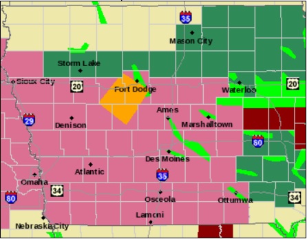
Counties in lavender are under a Severe Thunderstorm Watch until Noon today.
The National Weather Service in Des Moines says will be the potential for more severe weather today, including tornadoes, strong thunderstorm winds and large hail. There will also be the potential for locally heavy rainfall. Today may also bring a widespread significant wind event to the area in the late morning or afternoon.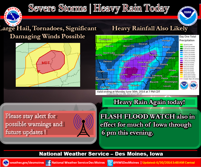 A Severe Thunderstorm Watch is in effect for the entire KJAN listening area until Noon today. And, a Flash Flood Watch is in effect until 2-p.m. for the Monona, Harrison, Shelby and Pottawattamie Counties. A Flash Flood Watch is in effect until 6-p.m. for the rest of the KJAN listening area.
Be prepared for dangerous storms that approach your area…stay alert to changing conditions and monitor your NOAA weather radio for forecast updates and possible watches and warnings. Review your severe weather safety procedures and move promptly to a place of safety if a warning is issued for your area.
Storms that developed Sunday afternoon in eastern Nebraska crossed into western Iowa’s Harrison County before spreading east through Shelby and Audubon Counties late into the evening, and then into central Iowa. The storms affecting our area dropped hail ranging in size from quarters in most locations, to baseball-sized hail near Magnolia.
There were also reports of funnel clouds in and around the Harlan and Elk Horn areas late Sunday evening, and one possible touchdown of a tornado in a rural area northwest of Harlan, but there were no immediate reports of damage.
AREA COUNTIES: SAC-CRAWFORD-CARROLL-AUDUBON-GUTHRIE-DALLAS-CASS-ADAIR-MADISON-ADAMS-UNION-TAYLOR-RINGGOLD-
343 AM CDT MON JUN 30 2014
…FLASH FLOOD WATCH NOW IN EFFECT THROUGH 6-P.M. TODAY (MONDAY)…
* THUNDERSTORMS CAPABLE OF HEAVY RAINFALL WILL CONTINUE TO DEVELOP AND TRACK ACROSS MUCH OF IOWA…OVER AREAS WHICH HAVE RECENTLY RECEIVED SEVERAL INCHES OF RAINFALL. ALREADY MOIST SOILS COMBINED WITH ADDITIONAL HEAVY RAINFALL OF 1 TO TWO INCHES…AND LOCAL HIGHER AMOUNTS…MAY LEAD TO AREAS OF FLASH FLOODING TODAY.
* MOST FLASH FLOOD DEATHS OCCUR IN VEHICLES. USE CAUTION WHILE TRAVELING. DO NOT DRIVE THROUGH FLOODED ROADWAYS…TURN AROUND DO NOT DROWN.
PRECAUTIONARY/PREPAREDNESS ACTIONS…
A FLASH FLOOD WATCH MEANS THAT CONDITIONS MAY DEVELOP THAT LEAD TO FLASH FLOODING. FLASH FLOODING IS A VERY DANGEROUS SITUATION. YOU SHOULD MONITOR LATER FORECASTS AND BE PREPARED TO TAKE ACTION SHOULD FLASH FLOOD WARNINGS BE ISSUED.
331 AM CDT MON JUN 30 2014
…FLASH FLOOD WATCH IN EFFECT THROUGH THIS AFTERNOON…
EARLY THIS MORNING…MOSTLY CLOUDY WITH ISOLATED THUNDERSTORMS. SOME THUNDERSTORMS MAY BE SEVERE. SOUTHWEST WIND NEAR 10 MPH. CHANCE OF THUNDERSTORMS 20 PERCENT.
TODAY...MOSTLY CLOUDY. ISOLATED THUNDERSTORMS THROUGH MID MORNING…THEN SCATTERED THUNDERSTORMS BEFORE NOON. NUMEROUS THUNDERSTORMS IN THE AFTERNOON. SOME THUNDERSTORMS MAY BE SEVERE…THEN SOME THUNDERSTORMS MAY BE SEVERE WITH DAMAGING WIND…LARGE HAIL AND HEAVY RAINFALL. HIGH IN THE LOWER 80S. SOUTHWEST WIND 5 TO 15 MPH. CHANCE OF THUNDERSTORMS 70 PERCENT.
TONIGHT…MOSTLY CLOUDY IN THE EVENING THEN CLEARING. SCATTERED THUNDERSTORMS IN THE EVENING. SOME THUNDERSTORMS MAY BE SEVERE WITH DAMAGING WIND…LARGE HAIL AND HEAVY RAINFALL. LOW IN THE LOWER 60S. WEST WIND 5 TO 15 MPH. CHANCE OF THUNDERSTORMS 50 PERCENT.
TUESDAY…MOSTLY SUNNY. A SLIGHT CHANCE OF SHOWERS AND ISOLATED THUNDERSTORMS IN THE AFTERNOON. BREEZY. HIGH IN THE UPPER 70S. WEST WIND 10 TO 20 MPH WITH GUSTS TO AROUND 30 MPH. CHANCE OF PRECIPITATION 20 PERCENT.
TUESDAY NIGHT AND WEDNESDAY…PARTLY CLOUDY. LOW IN THE MID 50S. HIGH 72 TO 79. NORTHWEST WIND 5 TO 15 MPH WITH GUSTS TO AROUND 25 MPH.
WEDNESDAY NIGHT THROUGH THURSDAY NIGHT...PARTLY CLOUDY. LOW IN THE UPPER 50S. HIGH IN THE MID 70S.
AREA COUNTIES: SAC-CRAWFORD-CARROLL-AUDUBON-GUTHRIE-DALLAS-CASS-ADAIR-MADISON-ADAMS-UNION-TAYLOR-RINGGOLD….A FLASH FLOOD WATCH REMAINS IN EFFECT UNTIL 7 AM CDT.
FLASH FLOODING IS ESPECIALLY DANGEROUS AT NIGHT…AND MOST FLASH FLOOD DEATHS OCCUR IN VEHICLES. USE CAUTION WHILE TRAVELING…ESPECIALLY AT NIGHT. DO NOT DRIVE THROUGH FLOODED ROADWAYS…TURN AROUND DO NOT DROWN.
PRECAUTIONARY/PREPAREDNESS ACTIONS…
A FLASH FLOOD WATCH MEANS THAT CONDITIONS MAY DEVELOP THAT LEAD
TO FLASH FLOODING. FLASH FLOODING IS A VERY DANGEROUS SITUATION.
256 AM CDT MON JUN 30 2014
AREAS OF HEAVY RAIN LIKELY THIS MORNING….HEAVY RAIN PRODUCING THUNDERSTORMS WILL LIKELY INCREASE IN COVERAGE OVER THE AREA THIS MORNING BEFORE SHIFTING INTO IOWA AROUND OR SHORTLY AFTER MIDDAY. ALTHOUGH NOT EVERY LOCATION WILL RECEIVE HEAVY RAIN…LOCAL AMOUNTS IN EXCESS OF 2 INCHES ARE POSSIBLE. WITH THE GROUND NEARLY SATURATED OVER MUCH OF THE AREA.
AREA COUNTIES IN IOWA: MONONA-HARRISON-SHELBY-POTTAWATTAMIE: FLASH FLOOD WATCH IN EFFECT FROM 6 AM THIS MORNING TO 2 PM CDT THIS AFTERNOON.
* RECENT HEAVY RAINS HAVE NEARLY SATURATED THE SOIL MAKING RUNOFF FROM HEAVIER RAIN MORE LIKELY. THIS COULD LEAD TO FLOODING OR FLASH FLOODING.
PRECAUTIONARY/PREPAREDNESS ACTIONS…
A FLASH FLOOD WATCH MEANS THAT CONDITIONS MAY DEVELOP THAT LEAD TO FLASH FLOODING. FLASH FLOODING IS A VERY DANGEROUS SITUATION. YOU SHOULD MONITOR LATER FORECASTS AND BE PREPARED TO TAKE ACTION SHOULD FLASH FLOOD WARNINGS BE ISSUED.
SHELBY IA-
829 PM CDT SUN JUN 29 2014
…THE TORNADO WARNING FOR CENTRAL SHELBY COUNTY IS CANCELLED…
THE STORM WHICH PROMPTED THE WARNING HAS WEAKENED BELOW SEVERE LIMITS…AND NO LONGER APPEARS CAPABLE OF PRODUCING A TORNADO. THEREFORE THE WARNING HAS BEEN CANCELLED.
A TORNADO WATCH REMAINS IN EFFECT UNTIL 1100 PM CDT SUNDAY FOR SOUTHWEST IOWA AND EASTERN NEBRASKA
809 PM CDT SUN JUN 29 2014
THE NATIONAL WEATHER SERVICE IN OMAHA HAS ISSUED A TORNADO WARNING FOR… WEST CENTRAL SHELBY COUNTY IN SOUTHWEST IOWA…UNTIL 845 PM CDT
* AT 808 PM CDT…A SEVERE THUNDERSTORM CAPABLE OF PRODUCING A TORNADO WAS LOCATED NEAR EARLING…OR 21 MILES SOUTH OF DENISON… MOVING EAST AT 30 MPH.
HAZARD…TORNADO.
SOURCE…RADAR INDICATED ROTATION.
IMPACT…FLYING DEBRIS WILL BE DANGEROUS TO THOSE CAUGHT WITHOUT SHELTER. MOBILE HOMES WILL BE DAMAGED OR DESTROYED. DAMAGE TO ROOFS…WINDOWS AND VEHICLES WILL OCCUR. TREE DAMAGE IS LIKELY.
* THIS TORNADIC THUNDERSTORM WILL REMAIN OVER MAINLY RURAL AREAS OF WEST CENTRAL SHELBY COUNTY…INCLUDING THE FOLLOWING LOCATIONS… PANAMA AND WESTPHALIA.
THIS INCLUDES HIGHWAY 59 IN IOWA BETWEEN MILE MARKERS 80 AND 83.
PRECAUTIONARY/PREPAREDNESS ACTIONS…
TAKE COVER NOW! MOVE TO A BASEMENT OR AN INTERIOR ROOM ON THE LOWEST FLOOR OF A STURDY BUILDING. AVOID WINDOWS. IF IN A MOBILE HOME…A VEHICLE OR OUTDOORS…MOVE TO THE CLOSEST SUBSTANTIAL SHELTER AND PROTECT YOURSELF FROM FLYING DEBRIS.


