
The National Weather Service has expanded the WINTER STORM WARNING for parts of southern and central Iowa to include most of the state. The Warning is in effect from 6-pm Sat. (1/31) until 9-pm Sunday (2/1), for Monona-Harrison-Shelby and Pottawattamie Counties in the KJAN listening area, and from 7-pm Sat. thru 9-pm Sunday for Cass, Adair, Adams, Audubon, Guthrie, Dallas, Sac, Crawford, Carroll, Ringgold, Taylor and Union Counties. In the warned area, 7-to 10-inches of snow are possible by Sunday night.
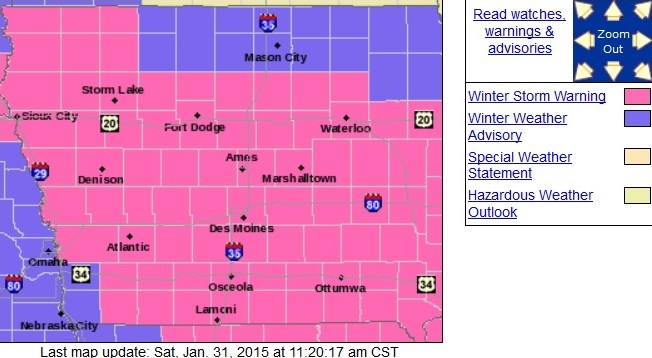
Counties in pink are in a Winter Storm Warning. Purple indicates Winter Weather Advisory.
Winds will turn to the northeast early Sunday morning at 10-to 20-mph and gust to near 30-mph by Sunday afternoon. Roads are expected to become snow covered and hazardous. Blowing snow Sunday will reduce visibility and make it difficult for state and county road crews to keep the roads clear. Travel on in the event of an emergency. If you must travel, keep an extra flashlight, food and water in your vehicle in case you become stranded.
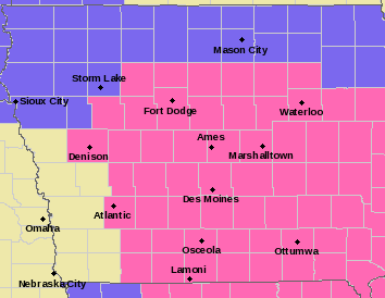
The rain-snow mix has changed over to all snow in western Iowa as of mid-day, Saturday. Heavy snow is possible overnight, with some additional light accumulation on Sunday. In addition to the WINTER STORM WARNING, a Winter Weather Advisory is in effect for far southwest Iowa from 9-p.m. Saturday until 6-pm Sunday for Fremont and Mills Counties.
Winter Storm Warning for Montgomery, Page, Monona, Harrison, Shelby, Pottawattamie Counties from 6pm this evening to 9pm Sunday.
Winter Storm Warning for Cass, Sac, Crawford, Carroll, Greene, Audubon, Guthrie, Adair, Madison, Adams, Union, Taylor, and Ringgold Counties from 7pm this evening to 9pm Sunday.
Winter Weather Advisory for Mills and Fremont Counties from 9pm this evening to 6pm Sunday.
Today: Rain and snow, becoming all snow after 5pm. High near 38. Southwest wind 10 to 15 mph becoming south southeast in the afternoon. Total daytime snow accumulation of less than a half inch possible.
Tonight: Snow. Low around 22. South southeast wind 10 to 15 mph becoming north northeast after midnight. New snow accumulation of 3 to 7 inches possible.
Sunday: Snow with patchy blowing snow before 3pm, then snow likely with patchy blowing snow after 3pm. Temperature falling to around 12 by 4pm. Wind chill values as low as -5. Windy, with a north wind 15 to 25 mph, with gusts as high as 35 mph. New snow accumulation of 2 to 4 inches possible.
Sunday Night: Cloudy, then gradually becoming partly cloudy, with a low around -2. Wind chill values as low as -10. Windy, with a north wind 15 to 20 mph decreasing to 5 to 10 mph after midnight. Winds could gust as high as 30 mph.
Monday: A slight chance of snow after noon. Partly sunny, with a high near 21. Light and variable wind becoming south 10 to 15 mph in the morning. Winds could gust as high as 20 mph.
Monday Night: A slight chance of snow before midnight. Mostly cloudy, with a low around 15.
Tuesday: Partly sunny, with a high near 36. Breezy.
Wednesday: Mostly cloudy, with a high near 24. Blustery.
Podcast: Play in new window | Download (1.0MB)
Subscribe: RSS
NATIONAL WEATHER SERVICE OMAHA/VALLEY NE
511 AM CST SAT JAN 31 2015

...POTENT STORM SYSTEM TO AFFECT THE REGION THROUGH SUNDAY...

.A MIX OF SNOW AND RAIN AND SNOW WILL DEVELOP AND SPREAD ACROSS
THE REGION TODAY...CHANGING TO ALL SNOW LATER TODAY AND
TONIGHT...WITH VERY STRONG WINDS AND BLOWING SNOW SUNDAY.

MILLS-FREMONT-
...WINTER WEATHER ADVISORY IN EFFECT FROM 9 PM THIS EVENING TO
6 PM CST SUNDAY...

THE NATIONAL WEATHER SERVICE IN OMAHA/VALLEY HAS ISSUED A WINTER
WEATHER ADVISORY FOR SNOW AND BLOWING SNOW...WHICH IS IN EFFECT
FROM 9 PM THIS EVENING TO 6 PM CST SUNDAY.

* TIMING...A MIX OF RAIN AND SNOW WILL CHANGE TO ALL SNOW THIS
  THIS AFTERNOON AND CONTINUE TONIGHT. SOME ADDITIONAL LIGHT SNOW
  ACCUMULATIONS WILL BE POSSIBLE SUNDAY. INITIALLY TEMPERATURES
  WILL BE NEAR OR ABOVE FREEZING WITH FALLING TEMPERATURES TONIGHT
  AND SUNDAY.

* UNCERTAINTY...PRECIPITATION IS LIKELY...HOWEVER MELTING DURING
  THE DAY AND HOW QUICKLY THE PRECIPITATION CHANGES OVER TO ALL
  SNOW WILL AFFECT EVENTUAL TOTAL SNOW AMOUNTS.

* STORM TOTAL SNOW...ACCUMULATIONS OF 2 TO 6 INCHES.

* WINDS/VISIBILITY...NORTHEAST WINDS TONIGHT WILL BECOME NORTHWEST
  20 TO 30 MPH AND GUSTY LATE TONIGHT AND SUNDAY.

* MAIN IMPACT...ROADS WILL BECOME SNOW COVERED AND HAZARDOUS.
  BLOWING SNOW ON SUNDAY WILL REDUCE VISIBILITY AND MAKE IT
  DIFFICULT TO KEEP THE ROADS CLEAR...ESPECIALLY IN OPEN AND
  RURAL AREAS.

* OTHER IMPACTS...THE COLD COMBINED WITH THE WIND SUNDAY WILL
  LOWER WIND CHILLS TO A RANGE OF 10 ABOVE TO 10 BELOW ZERO
  SUNDAY.

PRECAUTIONARY/PREPAREDNESS ACTIONS...

A WINTER WEATHER ADVISORY FOR SNOW MEANS THAT PERIODS OF SNOW
WILL CAUSE PRIMARILY TRAVEL DIFFICULTIES. BE PREPARED FOR SNOW
COVERED ROADS AND LIMITED VISIBILITIES...AND USE CAUTION WHILE
DRIVING.

A WINTER WEATHER ADVISORY FOR BLOWING SNOW MEANS THAT
VISIBILITIES WILL BE LIMITED DUE TO STRONG WINDS BLOWING SNOW
AROUND. USE CAUTION WHEN TRAVELING...ESPECIALLY IN OPEN AREAS.
(issued 4:12-a.m. Sat,/NWS Des Moines)
CLOUDS INCREASED FROM THE SOUTH ACROSS IOWA OVERNIGHT ALTHOUGH THERE WAS NO PRECIPITATION AS OF YET. LOWS REACHED THE UPPER TEENS TO LOWER 30S…BUT THE CLOUDS AND SOUTHWEST WINDS OF 5 TO 10 MPH LED TO TEMPERATURES SLOWLY RISING ABOVE THOSE VALUES HEADING TOWARD DAYBREAK.
Counties in pink have a Winter Storm Warning in effect from 7-pm 1/31-thru 9-p.m. 2/1/15
THE WEATHER WILL BECOME MUCH MORE ACTIVE THROUGH THE WEEKEND HOWEVER AS A LARGE LOW PRESSURE SYSTEM TRACKS FROM THE SOUTHWEST UNITED STATES INTO THE MID MISSISSIPPI VALLEY BY SUNDAY. A MIX OF RAIN AND SNOW WAS ALREADY FALLING ACROSS KANSAS THIS MORNING AND SIMILAR PRECIPITATION WILL EXPAND INTO IOWA AND SURROUNDING STATES LATER TODAY.
BY TONIGHT THE PRECIPITATION WILL SWITCH TO NEARLY ALL SNOW AND CONTINUE THROUGH SUNDAY. WIDESPREAD MODERATE TO HEAVY SNOW AMOUNTS ARE EXPECTED FROM IOWA INTO ILLINOIS WHERE 6 TO 10 INCHES MAY FALL AND WINTER STORM WARNINGS ARE IN EFFECT. WINDS WILL INCREASE AS THE SYSTEM EXITS SUNDAY AS WELL COMPOUNDING THE STORM EFFECTS WITH BLOWING AND DRIFTING SNOW.
THE PRECIPITATION WILL END BY SUNDAY NIGHT BUT BITTERLY COLD TEMPERATURES WILL RETURN HEADING INTO THE WORK WEEK. LOWS BY MONDAY MORNING ARE FORECAST TO BE IN THE SINGLE DIGITS ABOVE AND BELOW ZERO WITH WIND CHILLS IN THE SINGLE DIGITS AND TEENS BELOW ZERO.
Today: Rain and snow before 3pm, then rain between 3pm and 4pm, then rain and snow after 4pm. High near 38. Southwest wind 7 to 11 mph becoming south southeast in the afternoon. Chance of precipitation is 90%. Total daytime snow accumulation of less than a half inch possible.
**WINTER STORM WARNING FROM 7-PM SAT. THRU 9-PM SUNDAY**
Tonight: Snow. Low around 21. Southeast wind 6 to 14 mph becoming north northeast after midnight. Winds could gust as high as 18 mph. Chance of precipitation is 100%. New snow accumulation of 3 to 7 inches possible.
Sunday: Snow with patchy blowing snow before 3pm, then snow likely with patchy blowing snow after 3pm. Temperature falling to around 10 by 5pm. Wind chill values as low as -10. Windy, with a north wind 16 to 24 mph, with gusts as high as 33 mph. Chance of precipitation is 100%. New snow accumulation of 1 to 3 inches possible.
Sunday Night: Cloudy, then gradually becoming partly cloudy, with a low around -3. Wind chill values as low as -10. Blustery, with a north northwest wind 15 to 20 mph decreasing to 5 to 10 mph after midnight. Winds could gust as high as 28 mph.
Monday: A 20 percent chance of snow after noon. Partly sunny, with a high near 22. Light and variable wind becoming south 10 to 15 mph in the morning. Winds could gust as high as 21 mph.
Monday Night: A 20 percent chance of snow before midnight. Mostly cloudy, with a low around 15.
Tuesday: Partly sunny, with a high near 36. Breezy.
331 AM CST SAT JAN 31 2015: AREA COUNTIES…SAC-CRAWFORD-CARROLL-AUDUBON-GUTHRIE-CASS- DALLAS-ADAIR-MADISON-ADAMS-UNION-TAYLOR-RINGGOLD–
WINTER STORM WARNING IN EFFECT FROM 7 PM THIS EVENING TO 9 PM CST SUNDAY
THE NATIONAL WEATHER SERVICE IN DES MOINES HAS ISSUED A WINTER STORM WARNING FOR SNOW AND BLOWING SNOW…WHICH IS IN EFFECT FROM 7 PM THIS EVENING TO 9 PM CST SUNDAY.
* TIMING…RAIN WILL CHANGE TO SNOW BY THIS EVENING AND ACCUMULATE HEAVILY OVERNIGHT. SNOW WILL CONTINUE TO FALL THROUGH THE DAY SUNDAY WITH INCREASING WINDS.
* STORM TOTAL SNOW…ACCUMULATIONS OF 7 TO 10 INCHES WITH LOCALLY HIGHER AMOUNTS.
* WINDS/VISIBILITY…TURNING TO NORTHEAST 10 TO 20 MPH BY EARLY SUNDAY MORNING…THEN BECOMING NORTH 15 TO 25 MPH AND GUSTY BY SUNDAY AFTERNOON.
* IMPACTS…ROADS WILL BECOME SNOW COVERED AND HAZARDOUS. BLOWING SNOW ON SUNDAY WILL REDUCE VISIBILITY AND MAKE IT DIFFICULT TO CLEAR THE ROADS…ESPECIALLY IN OPEN AND RURAL AREAS.
PRECAUTIONARY/PREPAREDNESS ACTIONS…
A WINTER STORM WARNING FOR HEAVY SNOW MEANS SEVERE WINTER WEATHER CONDITIONS ARE EXPECTED OR OCCURRING. SIGNIFICANT AMOUNTS OF SNOW ARE FORECAST THAT WILL MAKE TRAVEL DANGEROUS. ONLY TRAVEL IN AN EMERGENCY. IF YOU MUST TRAVEL…KEEP AN EXTRA FLASHLIGHT…FOOD…AND WATER IN YOUR VEHICLE IN CASE OF AN EMERGENCY. ANY REPORTS OF SNOW…SLEET AND FREEZING RAIN ACCUMULATIONS ARE MUCH APPRECIATED AND CAN BE RELAYED DIRECTLY TO THE NATIONAL WEATHER SERVICE USING TWITTER HANDLE NWS DES MOINES…HASHTAG
NWSDMX OR POST TO THE NWS DES MOINES FACEBOOK PAGE.
AREA COUNTIES: DALLAS-ADAIR-MADISON-ADAMS-UNION-TAYLOR-RINGGOLD
WINTER STORM WATCH IN EFFECT FROM SATURDAY EVENING THROUGH SUNDAY AFTERNOON.
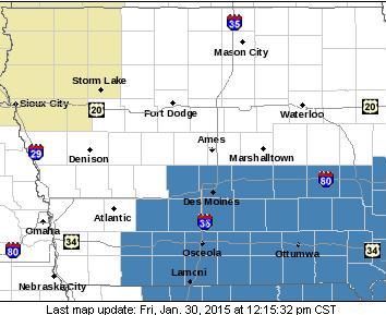
Winter Storm Watch covers the counties in blue.
THE NATIONAL WEATHER SERVICE IN DES MOINES HAS ISSUED A WINTER STORM WATCH…WHICH IS IN EFFECT FROM SATURDAY EVENING THROUGH SUNDAY AFTERNOON.
* TIMING…SNOW WILL PICK UP IN INTENSITY SATURDAY EVENING AND CONTINUE AT LIGHT TO MODERATE RATES INTO SUNDAY.
* STORM TOTAL SNOW…ACCUMULATIONS OF 5 TO 9 INCHES ARE EXPECTED WITH LOCALLY HIGHER AMOUNTS. HIGHEST AMOUNTS APPEAR TO BE MOST LIKELY IN THE EASTERN SIDE OF THE WATCH AREA.
* WINDS/VISIBILITY…NORTH WINDS WILL INCREASE SATURDAY NIGHT AND PERSIST INTO SUNDAY AT 15 TO 20 MPH WITH GUSTS TO 30 MPH.
* IMPACTS…ROADS WILL BECOME SLICK AND HAZARDOUS. DRIFTING SNOW WILL CREATE LOW VISIBILITIES SUNDAY AND MAY MAKE IT DIFFICULT FOR ROAD CREWS TO KEEP ROADS CLEAR…ESPECIALLY IN OPEN AREAS.
PRECAUTIONARY/PREPAREDNESS ACTIONS… A WINTER STORM WATCH MEANS THERE IS A POTENTIAL FOR SIGNIFICANT SNOW…SLEET…OR ICE ACCUMULATIONS THAT MAY IMPACT TRAVEL. CONTINUE TO MONITOR THE LATEST FORECASTS.
LINCOLN, Neb. (AP) – Parts of Iowa, Missouri and other Midwest states are teetering close to drought status. The National Drought Mitigation Center on Thursday classified a large swath of southern Iowa, areas along the northern Missouri border and the region east toward Illinois and Wisconsin as abnormally dry. This is one level below its moderate drought category. The label comes just a week after the center categorized the area as normal.
The Omaha World-Herald reports much of the Plains, including Minnesota, the Dakotas and southern Nebraska, were already near drought or in drought, and most of the region remains unchanged from last week. Much of the country has experienced a warmer and drier winter than normal. The drought center is located at the University of Nebraska-Lincoln.
The Freese-Notis weather forecast for Atlantic & the KJAN listening area, and weather data for Atlantic.
Podcast: Play in new window | Download (1.2MB)
Subscribe: RSS
Today: Sunny, with a high near 37. Light and variable wind becoming south southwest 8 to 13 mph in the morning.
Tonight: Partly cloudy, with a steady temperature around 33. South wind 7 to 10 mph.
Saturday: A chance of snow before noon, then rain likely between noon and 3pm, then rain and snow likely after 3pm. Cloudy, with a high near 38. Southwest wind 5 to 10 mph becoming southeast in the afternoon. Chance of precipitation is 70%. New snow accumulation of less than a half inch possible.
Saturday Night: Snow. Low around 23. East southeast wind 6 to 13 mph becoming north northeast after midnight. Winds could gust as high as 21 mph. Chance of precipitation is 80%. New snow accumulation of 1 to 3 inches possible.
Sunday: Snow likely, mainly before noon. Cloudy, with a high near 23. Windy, with a north wind 15 to 23 mph, with gusts as high as 32 mph. Chance of precipitation is 70%. New snow accumulation of around an inch possible.
Sunday Night: Mostly cloudy, with a low around 3. Blustery.
Monday: A 20 percent chance of snow. Partly sunny, with a high near 23


