
Today: A slight chance of rain or drizzle between 10am and 11am. Patchy fog before 9am. Otherwise, partly sunny, with a high near 41. Northwest wind 6 to 11 mph. Chance of precipitation is 20%.
Tonight: Mostly cloudy, with a low around 26. North wind 6 to 10 mph.
Monday: Mostly cloudy, with a high near 33. Northeast wind around 6 mph.
Monday Night: Mostly cloudy, with a low around 24. Southeast wind 5 to 9 mph.
Tuesday: Mostly cloudy, with a high near 39. South wind 10 to 14 mph, with gusts as high as 20 mph.
Tuesday Night: Mostly cloudy, with a low around 26.
Wednesday: Partly sunny, with a high near 34. Breezy.
Weather information from KJAN News Director Ric Hanson.
Podcast: Play in new window | Download (891.4KB)
Subscribe: RSS
345 AM CST SAT FEB 7 2015
EARLY THIS MORNING…MOSTLY CLEAR. AREAS OF FOG. SOUTH WIND NEAR 5 MPH.
TODAY…MOSTLY SUNNY. AREAS OF FOG THROUGH MID MORNING…THEN PATCHY FOG BEFORE NOON. HIGH IN THE MID 40S. SOUTHWEST WIND 5 TO 15 MPH.
TONIGHT…PARTLY CLOUDY IN THE EVENING THEN BECOMING MOSTLY CLOUDY. PATCHY FOG AFTER MIDNIGHT. LOW IN THE LOWER 30S. WEST WIND 5 TO 10 MPH.
SUNDAY…PARTLY SUNNY. PATCHY FOG THROUGH MID MORNING. HIGH IN THE LOWER 40S. NORTHWEST WIND 5 TO 15 MPH.
SUNDAY NIGHT…MOSTLY CLOUDY. LOW IN THE MID 20S. NORTH WIND 5 TO 10 MPH.
MONDAY…PARTLY SUNNY. HIGH IN THE UPPER 30S. NORTHEAST WIND 5 TO 10 MPH.
TUESDAY…PARTLY SUNNY. HIGH IN THE LOWER 40S.
The Freese-Notis forecast for the KJAN listening area, and weather information for Atlantic.
Podcast: Play in new window | Download (1,013.0KB)
Subscribe: RSS
(updated 4-a.m. 2/6/15 – NWS/Des Moines)
Today: Mostly sunny, with a high near 39. South wind 8 to 13 mph.
Tonight: Areas of fog after 1am. Otherwise, partly cloudy, with a low around 27. South southwest wind 5 to 7 mph.
Saturday: Areas of fog before 10am. Otherwise, mostly sunny, with a high near 43. South southwest wind 8 to 14 mph, with gusts as high as 18 mph.
Saturday Night: Patchy fog after 7pm. Otherwise, mostly cloudy, with a low around 29. West wind 6 to 8 mph.
Sunday: Areas of fog before 10am. Otherwise, mostly sunny, with a high near 42. West northwest wind 7 to 11 mph.
Sunday Night: Mostly cloudy, with a low around 24.
Monday: Mostly sunny, with a high near 35.
The Freese-Notis Weather forecast for Atlantic & the KJAN listening area and weather information for Atlantic.
Podcast: Play in new window | Download (1.0MB)
Subscribe: RSS
Today – Sunny, with a high near 19. Wind chill values as low as -25. Breezy, with a south wind 5 to 10 mph increasing to 12 to 17 mph in the afternoon. Winds could gust as high as 24 mph.
Tonight – Partly cloudy, with a low around 14. Wind chill values as low as zero. South southwest wind 7 to 13 mph.
Friday – Partly sunny, with a high near 37. Wind chill values as low as 5. South wind 8 to 13 mph.
Friday Night – Partly cloudy, with a low around 24. Southwest wind 6 to 8 mph.
Saturday – Mostly sunny, with a high near 42. South southwest wind 6 to 11 mph.
Saturday Night – Partly cloudy, with a low around 25.
Sunday – Mostly sunny, with a high near 39.
(Updated 10:45-a.m.
Snowfall reports from trained weather spotters & others, to the National Weather Service (time of report submitted, as indicated):
Atlantic (8:45-a.m.) 3.3″; Audubon, 2.0” (7-am); Essex 4.0″ (10:30-a.m.); 2 miles NW of Little Sioux in Harrison County, 1.3″ (7:30-am);Logan, 2.2″ (7:30-am); Massena, 1.5” (7:30-a.m.); Mt. Ayr, 1.3″ (8-am); Oakland, 1.1” (7:30-am); Red Oak, 4.0″ (9:50-a.m.); Shenandoah, 2.0″ (10:30-a.m.); Underwood, 1.4″ (10:30-a.m.)
Snow is moving across southern Iowa this morning. The National Weather Service in Johnston says snow fall totals will range from 1 to 3 inches south of Interstate 80 with the highest totals near the Missouri border.Winter Weather Advisories for snow and blowing snow have been posted for all counties along and south in I-80 thru the mid-day hours. Roads have become snow covered and with winds gusting up to 20 miles per hour, visibilities will fall below one-mile, especially in areas of heavier snowfall. Use caution while driving today.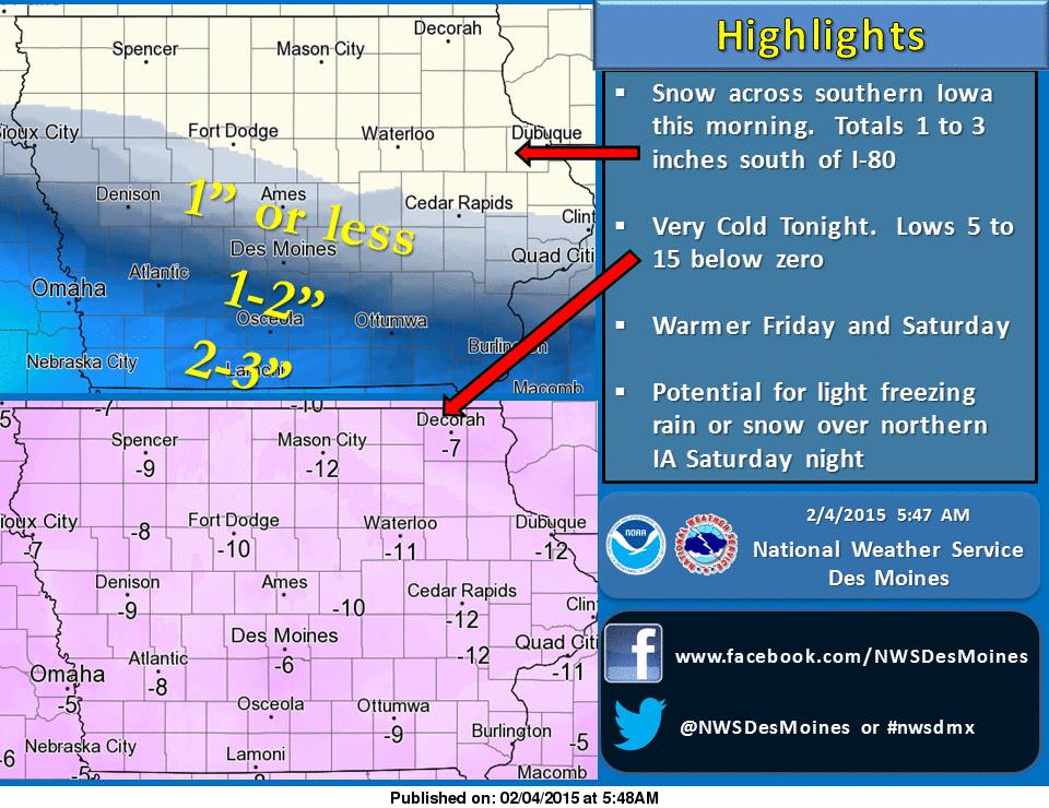
High Pressure will arrive tonight and will bring very cold temperatures to the state. Overnight lows will be 5 to 15 degrees below zero. Warmer temperatures arrive Friday into Saturday. Highs in the 30s and 40s are possible during this period.
CASS-ADAIR-MADISON COUNTIES…335 AM CST WED FEB 4 2015
…WINTER WEATHER ADVISORY IN EFFECT UNTIL 1 PM CST THIS AFTERNOON…
POTTAWATTAMIE-MILLS-MONTGOMERY COUNTIES: WINTER WEATHER ADVISORY IN EFFECT UNTIL NOON TODAY.
ADAMS-UNION-TAYLOR AND RINGGOLD COUNTIES: WINTER WEATHER ADVISORY IN EFFECT FROM 6-AM TODAY UNTIL 1-P.M.
FREMONT AND PAGE COUNTIES: WINTER WEATHER ADVISORY IN EFFECT UNTIL 1-P.M.
THE NATIONAL WEATHER SERVICE IN DES MOINES HAS ISSUED A WINTER WEATHER ADVISORY FOR SNOW AND BLOWING SNOW…WHICH IS IN EFFECT UNTIL 1 PM CST THIS AFTERNOON.
* TIMING…SNOW WILL BEGIN BY SUNRISE IN SOUTHWEST IOWA AND MOVE ACROSS SOUTH CENTRAL IOWA BEFORE NOON.
* STORM TOTAL SNOW ACCUMULATIONS…2 TO 4 INCHES.
* WINDS/VISIBILITY…NORTH WINDS INCREASING TO 15 TO 20 MPH WITH HIGHER GUSTS BY LATE MORNING. VISIBILITY WILL FALL BELOW A MILE DURING HEAVIER SNOWFALL.
* IMPACTS…ROADS WILL BECOME SNOW COVERED AND LOW VISIBILITY WILL MAKE TRAVEL HAZARDOUS.
PRECAUTIONARY/PREPAREDNESS ACTIONS…
A WINTER WEATHER ADVISORY FOR SNOW MEANS THAT PERIODS OF SNOW WILL CAUSE PRIMARILY TRAVEL DIFFICULTIES. BE PREPARED FOR SNOW COVERED ROADS AND LIMITED VISIBILITIES…AND USE CAUTION WHILE DRIVING.


