
345 AM CDT TUE MAR 31 2015
EARLY THIS MORNING…CLEAR. NOT AS COOL. NORTH WIND NEAR 5 MPH.
TODAY…SUNNY. HIGH IN THE LOWER 70S. WEST WIND NEAR 5 MPH.
TONIGHT…MOSTLY CLEAR. LOW IN THE UPPER 40S. SOUTH WIND 5 TO 15 MPH.
WEDNESDAY…MOSTLY SUNNY. A 20 PERCENT CHANCE OF THUNDERSTORMS LATE IN THE AFTERNOON. BREEZY. HIGH IN THE LOWER 80S. SOUTH WIND 15 TO 25 MPH. GUSTS UP TO 30 MPH INCREASING TO 40 MPH IN THE AFTERNOON.
WEDNESDAY NIGHT…THUNDERSTORMS THROUGH MIDNIGHT…THEN THUNDERSTORMS LIKELY AFTER MIDNIGHT. BREEZY. LOW IN THE UPPER 40S. SOUTH WIND 15 TO 25 MPH WITH GUSTS TO AROUND 35 MPH BECOMING NORTHWEST 5 TO 10 MPH AFTER MIDNIGHT. CHANCE OF THUNDERSTORMS NEAR 100 PERCENT.
THURSDAY…PARTLY SUNNY. A 20 PERCENT CHANCE OF SHOWERS IN THE MORNING. COOLER. HIGH IN THE MID 60S. NORTHWEST WIND 10 TO 15 MPH WITH GUSTS TO AROUND 25 MPH.
FRIDAY…PARTLY SUNNY. COOLER. HIGH IN THE LOWER 50S.
Officials with the Shelby County Emergency Management Agency are requesting participating businesses and fire departments in the County, to place their local “Fire Danger” indicator signs in the EXTREME category, now through Thursday.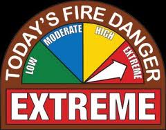
The western half of Iowa is under a Red Flag Warning this afternoon, and officials say they expect the same dangerous conditions to be present for the next days. High wind and low humidity will cause any fires that start to quickly grow out of control.
Extreme conditions mean, absolutely no outdoor burning. Permits need to be completed and signed by a Fire Chief before any controlled burns are executed during extreme conditions. There is a chance of rain Wednesday afternoon, and a better chance Wednesday night, but until rain puts a dent in the dangerous conditions, outdoor burning is prohibited.
The Freese-Notis forecast for the KJAN listening area and weather info. for Atlantic
Podcast: Play in new window | Download (1.1MB)
Subscribe: RSS
414 AM CDT MON MAR 30 2015
A RED FLAG WARNING is IN EFFECT FROM NOON TODAY UNTIL 7- PM FOR THE ENTIRE WESTERN HALF OF IOWA, INCLUDING ALL COUNTIES IN THE KJAN LISTENING AREA. THE RED FLAG WARNING IS FOR EXTREME FIRE CONDITIONS.
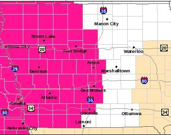
Red Flag Warning for counties shaded in pinkish-red.
* WIND…SOUTHWEST TO WEST WINDS AT 20 TO 25 MPH WITH FREQUENT GUSTS TO 30 MPH.
* RELATIVE HUMIDITY…HUMIDITY VALUES WILL DROP TO AROUND 20 PERCENT THIS AFTERNOON.
* FUEL…GRASSES REMAIN NEARLY 100 PERCENT CURED ACROSS THE WARNING AREA.
* IMPACTS…ANY FIRES THAT DEVELOP WILL HAVE THE POTENTIAL TO SPREAD VERY RAPIDLY DUE TO WINDY AND DRY CONDITIONS. ANY OUTDOOR BURNING IS HIGHLY DISCOURAGED AND SHOULD BE AVOIDED TODAY.
PRECAUTIONARY/PREPAREDNESS ACTIONS…
A RED FLAG WARNING MEANS THAT CRITICAL FIRE WEATHER CONDITIONS ARE EITHER OCCURRING NOW…OR WILL SHORTLY. A COMBINATION OF STRONG WINDS…LOW RELATIVE HUMIDITY…AND WARM TEMPERATURES WILL CREATE EXPLOSIVE FIRE GROWTH POTENTIAL.
Today: Mostly sunny, with a high near 74. Windy, with a southwest wind 5 to 10 mph increasing to 16 to 21 mph in the afternoon. Winds could gust as high as 29 mph.
Tonight: Mostly clear, with a low around 41. West southwest wind 6 to 11 mph becoming north after midnight.
Tuesday: Sunny, with a high near 74. North wind around 6 mph becoming west in the afternoon.
Tuesday Night: Mostly clear, with a low around 48. Light south wind becoming south southeast 8 to 13 mph in the evening.
Wednesday: A 30 percent chance of showers and thunderstorms after 1pm. Partly sunny, with a high near 78. Windy, with a south wind 15 to 24 mph, with gusts as high as 33 mph. New rainfall amounts of less than a tenth of an inch, except higher amounts possible in thunderstorms.
Wednesday Night: Showers and thunderstorms likely. Mostly cloudy, with a low around 47. Breezy. Chance of precipitation is 70%. New rainfall amounts between three quarters and one inch possible.
Thursday: A slight chance of showers before 1pm. Mostly sunny, with a high near 64. Chance of precipitation is 20%.
MONONA-HARRISON-SHELBY-POTTAWATTAMIE-MILLS-MONTGOMERY-FREMONT- PAGE COUNTIES…354 AM CDT MON MAR 30 2015 …
RED FLAG WARNING IN EFFECT FROM NOON TODAY TO 7 PM CDT THIS EVENING DUE TO WIND AND LOW RELATIVE HUMIDITY FOR EASTERN NEBRASKA AND SOUTHWEST IOWA…
THE NATIONAL WEATHER SERVICE IN OMAHA/VALLEY HAS ISSUED A RED FLAG WARNING DUE TO WIND AND LOW RELATIVE HUMIDITY…WHICH IS IN EFFECT FROM NOON TODAY TO 7 PM CDT THIS EVENING.
* WINDS…WEST 10 TO 20 MPH WITH GUSTS AROUND 30 MPH. * RELATIVE HUMIDITY…AS LOW AS 16 PERCENT.
* IMPACTS…CONDITIONS THIS AFTERNOON WILL BE FAVORABLE FOR EXTREME FIRE BEHAVIOR WITH A HIGH POTENTIAL FOR OUT OF CONTROL BURNS.
PRECAUTIONARY/PREPAREDNESS ACTIONS…
A RED FLAG WARNING MEANS THAT CRITICAL FIRE WEATHER CONDITIONS ARE EITHER OCCURRING NOW…OR WILL SHORTLY.
Today: Wind Advisory from 10-a.m. thru late this afternoon/evening. Mostly Cloudy this morning; Gradually becoming sunny & windy. High near 62. S/SW winds 15-30 w/gusts to around 45 mph.
Tonight: Mostly clear & breezy. Low around 33. NW-W winds @ 15-25 diminishing to around 5-10 after midnight.
Monday: Sunny & breezy. High near 72. SW winds @ 10-20 mph gusting to near 30.
Monday Night: Mostly clear, with a low around 39. SW wind 5 to 15 mph becoming west northwest after midnight & gusting up to 20 mph.
Tuesday: Sunny, with a high near 73. North wind around 5-10 mph.
Tuesday Night: Mostly clear, with a low around 45.
Wednesday: A 40 percent chance of showers & thunderstorms after 1-pm, otherwise. Mostly sunny & windy. High near 75.
Saturday’s High in Atlantic was 50. Our Low was 32. We received .03″ rain overnight thru early Sunday morning, here at the KJAN studios. Last year on this date we reached 53 for a High, 26 was our Low. The All-Time Record High in Atlantic on March 29th was 90 in 1896. The Record Low was 5 in 1969. Sunrise today is at 7:09 and Sunset will be at 7:42.
Weather experts have been spending this past week preparing Iowans for springtime threats such as tornadoes, hail and lightning. National Weather Service meteorologist Todd Heitkamp is also trying to dispel the many myths associated with severe weather. For instance, lightning can strike twice in the same spot. “There’s no doubt that’s a myth,” Heitkamp says. “Lightning can strike as often as it wants to and more often than not, lightning will strike the same place multiple times.”
Some Iowans might believe it’s a good idea to open windows and seek shelter in the southwest corner of a home in event of a tornado. That’s not the best advice, according to Heitkamp.”We want people to seek shelter underneath something sturdy or in a small, interior room. Stay out of the corners because the corners are actually the worst possible places to be during a tornado,” Heitkamp says.
“Opening the windows — it makes no difference. If the tornado wants the windows open, believe me, it is going to open them whether you like it or not. You better utilize that time to get yourself and your family members to your place of safety.” Another common falsehood about tornadoes is they’ll never cross a body of water.
“Nothing stops a tornado other than the tornado itself,” Heitkamp says. “Tornadoes can cross bodies of water — lakes, rivers and streams.” Heitkamp says knowing the difference between weather myths and weather facts may help save your life. The past week was designated as Severe Weather Awareness Week.
(Radio Iowa)
Podcast: Play in new window | Download (775.7KB)
Subscribe: RSS
Today: Scattered flurries, mainly before 7am. Cloudy, then gradually becoming mostly sunny, with a high near 49. East southeast wind 5 to 14 mph.
Tonight: A slight chance of rain, mainly between 4am and 5am, then a chance of showers after 5am. Increasing clouds, with a low around 37. Breezy, with a south southeast wind 14 to 18 mph, with gusts as high as 26 mph. Chance of precipitation is 30%. New precipitation amounts of less than a tenth of an inch possible.
Sunday: A 40 percent chance of showers, mainly before 8am. Mostly cloudy, then gradually becoming sunny, with a high near 60. Windy, with a south southwest wind 15 to 25 mph becoming northwest in the afternoon. Winds could gust as high as 36 mph. New precipitation amounts of less than a tenth of an inch possible.
Sunday Night: Mostly clear, with a low around 35. Breezy, with a west northwest wind 13 to 18 mph decreasing to 6 to 11 mph after midnight. Winds could gust as high as 25 mph.
Monday: Sunny, with a high near 70. Breezy, with a southwest wind 7 to 16 mph, with gusts as high as 22 mph.
Tuesday: Sunny, with a high near 71.


