
319 PM CDT SAT JUL 11 2015 ...HOT AND HUMID SUNDAY AND MONDAY…
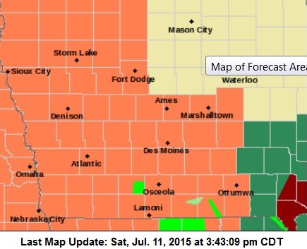
Counties in orange are included in the Heat Advisories for Sun. & Monday
MAXIMUM TEMPERATURES ARE FORECAST TO RISE INTO THE LOWER 90S BY SUNDAY AFTERNOON AND INTO THE MIDDLE TO UPPER 90S MONDAY. DEW POINTS ARE ANTICIPATED RANGE IN THE MIDDLE 70S BOTH DAYS…PLUS THE RECENT RAIN FROM SATURDAY MORNING SHOULD ADD TO THE HUMIDITY AND MAKE CONDITIONS EXTREMELY BALMY.
MONONA-HARRISON-SHELBY-POTTAWATTAMIE-MILLS-MONTGOMERY-FREMONT- PAGE COUNTIES:HEAT ADVISORY IN EFFECT FROM 1 PM TO 8 PM CDT SUNDAY. HEAT INDICES WILL RANGE FROM 100 TO NEAR 110 DEGREES SUNDAY AFTERNOON AND EVENING.
COUNTIES: CRAWFORD-CARROLL-GREENE-BOONE-STORY-AUDUBON-GUTHRIE-DALLAS-POLK- JASPER-CASS-ADAIR-MADISON-WARREN-MARION-MAHASKA-ADAMS-UNION– CLARKE-LUCAS-MONROE-WAPELLO-TAYLOR-RINGGOLD-DECATUR-WAYNE- APPANOOSE-DAVIS-
HEAT ADVISORY IN EFFECT FROM NOON TO 7 PM CDT SUNDAY… HEAT ADVISORY IN EFFECT FROM NOON TO 7 PM CDT MONDAY..
TEMPERATURE…ON SUNDAY…EXPECT MAXIMUM TEMPERATURES TO RISE INTO THE LOWER 90S AND DEW POINTS IN THE MIDDLE 70S. THE COMBINATION OF HOT TEMPERATURES AND HIGH HUMIDITY WILL LEAD TO HEAT INDEX VALUES RANGING FROM 100 TO 105 DEGREES. MONDAY LOOKS TO BE EVEN HOTTER WITH MAXIMUM TEMPERATURES RISING INTO THE MIDDLE TO UPPER 90S AND HEAT INDEX VALUES RANGING FROM 103 TO 108. A FEW AREAS MAY APPROACH 110 DEGREE HEAT INDEX BY MONDAY AFTERNOON.
PRECAUTIONARY/PREPAREDNESS ACTIONS… A HEAT ADVISORY MEANS THAT A PERIOD OF HOT TEMPERATURES IS EXPECTED. THE COMBINATION OF HOT TEMPERATURES AND HIGH HUMIDITY WILL COMBINE TO CREATE A SITUATION IN WHICH HEAT ILLNESSES ARE POSSIBLE. DRINK PLENTY OF FLUIDS…STAY IN AN AIR-CONDITIONED ROOM…STAY OUT OF THE SUN…AND CHECK UP ON RELATIVES AND NEIGHBORS. TAKE EXTRA PRECAUTIONS…IF YOU WORK OR SPEND TIME OUTSIDE. WHEN POSSIBLE…RESCHEDULE STRENUOUS ACTIVITIES TO EARLY MORNING OR EVENING. KNOW THE SIGNS OF HEAT EXHAUSTION AND HEAT STROKE. WEAR LIGHT WEIGHT AND LOOSE FITTING CLOTHING WHEN POSSIBLE AND DRINK PLENTY OF WATER.
Podcast: Play in new window | Download (605.5KB)
Subscribe: RSS
The Freese-Notis (podcast) weather forecast for Atlantic & the KJAN listening area, and weather information for Atlantic.
Podcast: Play in new window | Download (1.0MB)
Subscribe: RSS
Early This Morning: Mostly cloudy. South wind near 5 mph.
Today: Partly sunny. A 20 percent chance of thunderstorms late in the afternoon. High around 80. Southeast wind near 10 mph.
Tonight: A chance of thunderstorms in the evening…then thunderstorms likely before midnight. Thunderstorms after midnight. Low in the upper 60s. Southeast wind 5 to 10 mph. Chance of thunderstorms 90 percent.
Saturday: Mostly cloudy until late afternoon then becoming mostly sunny. Thunderstorms through mid morning…then a chance of thunderstorms in the late morning and early afternoon. A slight chance of thunderstorms late in the afternoon. High in the mid 80s. South wind 10 to 15 mph. Chance of thunderstorms 90 percent.
Saturday Night: Partly cloudy. Low in the lower 70s. South wind 5 to 15 mph.
Sunday: Sunny. High in the lower 90s. Southwest wind 5 to 10 mph. Highest heat index readings 100 to 105 in the afternoon.
Sunday Night: Partly cloudy. Low in the lower 70s.
Monday: Mostly sunny. High in the lower 90s.
The Freese-Notis (podcast) weather forecast for Atlantic & the KJAN listening area, and weather information for Atlantic.
Podcast: Play in new window | Download (939.2KB)
Subscribe: RSS
343 AM CDT THU JUL 9 2015
EARLY THIS MORNING…MOSTLY CLOUDY. PATCHY FOG. SOUTH WIND NEAR 5 MPH.
TODAY…MOSTLY SUNNY. PATCHY FOG THROUGH MID MORNING. HIGH IN THE UPPER 70S. SOUTH WIND NEAR 10 MPH.
TONIGHT…MOSTLY CLOUDY. LOW IN THE LOWER 60S. SOUTH WIND 5 TO 10 MPH.
FRIDAY…MOSTLY CLOUDY. SCATTERED THUNDERSTORMS IN THE AFTERNOON. HIGH IN THE LOWER 80S. SOUTHEAST WIND 5 TO 15 MPH. CHANCE OF THUNDERSTORMS 30 PERCENT.
FRIDAY NIGHT…THUNDERSTORMS LIKELY. LOW IN THE UPPER 60S. SOUTH WIND 5 TO 15 MPH. CHANCE OF THUNDERSTORMS 70 PERCENT.
SATURDAY…PARTLY SUNNY. A CHANCE OF THUNDERSTORMS IN THE MORNING…THEN A SLIGHT CHANCE OF THUNDERSTORMS IN THE AFTERNOON. HIGH IN THE UPPER 80S. SOUTH WIND 10 TO 15 MPH. CHANCE OF THUNDERSTORMS 40 PERCENT.
SUNDAY…MOSTLY SUNNY. HIGH IN THE LOWER 90S.
The Freese-Notis (podcast) weather forecast for Atlantic & the KJAN listening area, and weather information for Atlantic.
Podcast: Play in new window | Download (974.1KB)
Subscribe: RSS
336 AM CDT WED JUL 8 2015
EARLY THIS MORNING: PARTLY CLOUDY. NORTHEAST WIND AROUND 5 MPH.
TODAY: PARTLY SUNNY. HIGH IN THE LOWER 70S. EAST WIND 5 TO 10 MPH.
TONIGHT: MOSTLY CLOUDY. LOW IN THE MID 50S. SOUTHEAST WIND AROUND 5 MPH SHIFTING TO THE SOUTH AFTER MIDNIGHT.
THURSDAY: PARTLY SUNNY. HIGH IN THE MID 70S. SOUTH WIND 5 TO 10 MPH.
THURSDAY NIGHT: MOSTLY CLOUDY WITH SCATTERED THUNDERSTORMS. LOW IN THE LOWER 60S. SOUTHEAST WIND 5 TO 10 MPH. CHANCE OF THUNDERSTORMS 30 PERCENT.
FRIDAY: MOSTLY CLOUDY WITH SCATTERED THUNDERSTORMS. HIGH AROUND 80. SOUTHEAST WIND 5 TO 15 MPH. CHANCE OF THUNDERSTORMS 30 PERCENT.
FRIDAY NIGHT: MOSTLY CLOUDY WITH A 50 PERCENT CHANCE OF THUNDERSTORMS. LOW IN THE UPPER 60S.
SATURDAY: PARTLY SUNNY WITH A 50 PERCENT CHANCE OF THUNDERSTORMS. HIGH IN THE MID 80S.
The Freese-Notis forecast for Atlantic & the area, and weather data for Atlantic from KJAN News Director Ric Hanson.
Podcast: Play in new window | Download (1.1MB)
Subscribe: RSS
Early This Morning: Mostly clear. Cooler. Areas of smoke (from the Canadian Wild fires). North wind around 10 mph.
Today: Sunny. Patchy smoke in the morning. High in the lower 70s. North wind 10 to 15 mph.
Tonight: Partly cloudy. Low in the lower 50s. Northeast wind 5 to 10 mph.
Wednesday: Mostly sunny. High in the lower 70s. East wind 5 to 10 mph.
Wednesday Night: Partly cloudy through midnight then becoming mostly cloudy. Low in the mid 50s. East wind 5 to 10 mph shifting to the south after midnight.
Thursday: Partly sunny with a 20 percent chance of thunderstorms. High in the mid 70s. Southeast wind around 5 mph.
Thursday Night: Mostly cloudy with scattered thunderstorms. Low in the lower 60s. Chance of thunderstorms 50 percent.
Friday: Mostly cloudy with a 50 percent chance of thunderstorms. High in the lower 80s.


