
Early This Morning: Cloudy. East wind 5 to 15 mph.
Today: Cloudy. A slight chance of showers through mid morning… Then a chance of showers in the late morning and early afternoon. A chance of rain late in the afternoon. High in the mid 50s. East wind 5 to 10 mph. Chance of precipitation 50 percent.
Tonight: Cloudy. A chance of rain until early morning…then a slight chance of rain early in the morning. Low in the mid 40s. Northeast wind near 5 mph shifting to the northwest after midnight. Chance of rain 50 percent.
Wednesday: Mostly cloudy in the morning then becoming mostly sunny. Breezy. High in the lower 50s. Northwest wind 15 to 25 mph with gusts to around 35 mph.
Wednesday Night: Mostly clear. Colder. Low in the lower 30s. Northwest wind 10 to 15 mph with gusts to around 25 mph.
Thursday: Sunny. High in the lower 50s. Northwest wind 10 to 15 mph with gusts to around 25 mph.
Thursday Night: Partly cloudy. Low in the lower 30s.
Friday: Mostly cloudy. A 20 percent chance of rain showers in the afternoon. High in the mid 50s.
The Shelby County Emergency Management Agency reports, with much of the crop being in the bins now, the amount of fuel necessary for opening burning to spread beyond an intended area, has been reduced. Therefore, the local Fire Danger threat is being reduced to “Moderate,” from now through late this week.
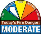 Officials warn that grassland is still very dry, and fires which start there can run for a long time until out of fuel, and spread to structures. Persons are advised to please let your Fire Chief know in advance of the time and location of any burns to prevent needless responses from local volunteer firefighters. The next update will be Thursday October 29, 2015
Today: Partly Cloudy. High 63. SE winds @ 10-15.
Tonight: P/Cldy to Cloudy. Low 46. SE @ 5-10.
Tomorrow: Cldy w/rain. High 53. E/SE @ 10-20.
Wednesday: P/Cldy w/a few sprinkles. High 50.
Thursday: P/Cldy. High 55.
Sunday’s High in Atlantic was 64. Our 24-hour Low ending at 7-a.m. today was 29. Last year on this date, our High was 76 and the Low was 46. The All-time Record High in Atlantic on Oct. 26th was 84 in 1956. The All-Time record low was 14 in 1980. Sunrise today is at 7:43, and sunset tonight will take place at 6:23.
342 AM CDT MON OCT 26 2015
EARLY THIS MORNING: MOSTLY CLEAR. SOUTHEAST WIND AROUND 5 MPH.
TODAY: MOSTLY SUNNY. HIGH IN THE MID 60S. SOUTHEAST WIND 5 TO 10 MPH.
TONIGHT: MOSTLY CLOUDY. LOW IN THE MID 40S. EAST WIND 5 TO 10 MPH.
TUESDAY: CLOUDY. A SLIGHT CHANCE OF LIGHT SHOWERS IN THE MORNING. THEN A CHANCE OF SHOWERS IN THE AFTERNOON. HIGH IN THE UPPER 50S. EAST WIND 5 TO 10 MPH. CHANCE OF SHOWERS 50 PERCENT.
TUESDAY NIGHT: MOSTLY CLOUDY WITH A 20 PERCENT CHANCE OF SHOWERS. LOW IN THE LOWER 40S. EAST WIND NEAR 5 MPH SHIFTING TO THE WEST AFTER MIDNIGHT.
WEDNESDAY: MOSTLY SUNNY. BREEZY. HIGH IN THE LOWER 50S. NORTHWEST WIND 10 TO 20 MPH WITH GUSTS TO AROUND 30 MPH.
THURSDAY: SUNNY. HIGH IN THE LOWER 50S.
242 AM CDT SUN OCT 25 2015
EARLY THIS MORNING…CLEAR…COLDER. SOUTHWEST WIND NEAR 5 MPH.
TODAY…SUNNY. HIGH IN THE MID 60S. SOUTH WIND NEAR 10 MPH.
TONIGHT…PARTLY CLOUDY. LOW AROUND 40. SOUTHEAST WIND 5 TO 10 MPH.
MONDAY…MOSTLY SUNNY. HIGH IN THE LOWER 60S. SOUTHEAST WIND 5 TO 10 MPH.
MONDAY NIGHT…MOSTLY CLOUDY. LOW IN THE MID 40S. SOUTHEAST WIND 5 TO 10 MPH.
TUESDAY…MOSTLY CLOUDY WITH A 50 PERCENT CHANCE OF SHOWERS. HIGH IN THE UPPER 50S. SOUTHEAST WIND 5 TO 10 MPH.
TUESDAY NIGHT…CLOUDY WITH A 50 PERCENT CHANCE OF LIGHT SHOWERS. LOW IN THE MID 40S.
WEDNESDAY…PARTLY SUNNY WITH A 20 PERCENT CHANCE OF LIGHT SHOWERS. HIGH IN THE LOWER 50S.
DES MOINES, Iowa (AP) — A band of storms produced some sightings of tornadoes in northwest Iowa Friday night, but there were no reports of injuries or significant damage. Kathy Stodola is duty officer for the Iowa emergency management department. She says that there was a report Friday evening of a roof torn off a building in Cherokee county.
The National Weather service says it received four reports of tornadoes, three in Sioux county and one in Cherokee county. Stodola said she expected the weather service to do an evaluation on the ground after daylight today (Saturday).
Podcast: Play in new window | Download (478.2KB)
Subscribe: RSS
Today: Showers and possibly a thunderstorm. High near 67. S @ 15-25. New rainfall amounts between a tenth and quarter of an inch, except higher amounts possible in thunderstorms.
Tonight: Cloudy to Partly Cloudy w/showers and thunderstorms mainly before 10pm. Low around 47. Winds becoming NW @ 10-15. New precipitation amounts of less than a tenth of an inch, except higher amounts possible in thunderstorms.
Saturday: Mostly sunny & breezy. High near 62. NW @ 15-25.
Sat. Night: Mostly clear. Low around 37.
Sunday: Partly Cloudy. High near 68.
Monday: Partly to Mostly sunny, with a high near 66.
Thursday’s High in Atlantic was 66. Our 24-hour Low (ending today at 7-a.m.), was 50. We received .23” of rain overnight into early this morning (through 7-a.m.) here at the KJAN studios. Last year on this date, our High was 74 and the Low was 43. The All-time record High for Atlantic on Oct. 23rd, was 81 in 1901 & 1991. The All-time record Low of 13 was set in 1895.
Early This Morning: Showers. Southeast wind 10 to 15 mph. Chance of showers 80 percent.
Today: Cloudy. Showers and isolated thunderstorms in the morning… Then scattered showers and isolated thunderstorms in the afternoon. High in the upper 60s. South wind 10 to 15 mph with gusts to around 25 mph. Chance of precipitation 90 percent.
Tonight: Mostly cloudy. A chance of showers and isolated thunderstorms through midnight. Low in the upper 40s. Southwest wind 10 to 15 mph shifting to the northwest after midnight. Chance of precipitation 50 percent.
Saturday: Mostly sunny. High in the lower 60s. Northwest wind 10 to 15 mph with gusts to around 25 mph.
Saturday Night: Mostly clear. Colder. Low in the upper 30s. North wind near 10 mph.
Sunday: Sunny. High in the mid 60s. South wind near 10 mph.
Monday: Partly sunny. High in the lower 60s.


