
The Shelby County Emergency Management Agency is asking local fire stations and businesses in the County to move their “Fire Danger” placards into the “Moderate” category, this week. Authorities say as the snow cover disappears, the sunshine will quickly dry the vegetation, creating the potential for controlled burns to spread out of control.
Fires can start from most accidental causes, but with the exception of lightning fires in some areas, the number of starts is generally low. Fires in open-cured grassland will burn briskly and spread rapidly on windy days. Woods fires spread slowly to moderately fast. The average fire is of moderate intensity, although heavy concentrations of fuel, especially draped fuel, may burn hot. Short-distance spotting may occur, but is not persistent. Fires are not likely to become serious, and control is relatively easy. The color code is blue. 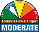
The next Local update will be Thursday, March 2nd.
(Updated 5-a.m.)
Today: Partly Cloudy. High 50. S @ 10-15.
Tonight: Cloudy w/light rain or drizzle. Low 38. S @ 10.
Tomorrow: Cldy w/light rain or drizzle in the morning. High 52. S-NW @ 10-20.
Wednesday: Mo. Cldy. High 38.
Thursday: Mo. Cldy. High 38.
Sunday’s High in Atlantic was 43. Our Low this morning (As of 5-a.m.), was 19. Last year on this date, our High in Atlantic was 71 and the low was 23. The Record High in Atlantic on this date was 71 in 2016. The Record Low was -16 in 1960.
Today: Sunny, with a high near 42. W-SW wind 5-10mph.
Tonight: Patchy fog after 9pm. Otherwise, mostly clear, with a low around 22.
Monday: Mostly sunny, with a high near 49. South wind 5 to 10 mph.
Monday Night: Mostly cloudy w/a 40% chance of rain, mainly before midnight. Low around 38. New precipitation amounts of less than a tenth of an inch possible.
Tuesday: Mo. cloudy w/a 20% chance of rain before noon. High near 52. S/SE winds becoming NW at 5-10.
Tuesday Night: A 40% chance of rain becoming mixed with and changing over to snow early Wednesday morning. Low around 29. New precipitation amounts of less than a tenth of an inch possible.
Wednesday: Partly sunny & breezy, with a high near 40.
Skyscan Forecast Saturday, February 25, 2017 Chris Parks
Today: Partly cloudy. High 33. NW @ 10-15.
Tonight: Partly cloudy. Low 25. SSW @ 5-10 increasing to 10-15.
Sunday: Clouds and sun mix. Warmer. High 46. WSW @ 10-15.
Sunday Night: Partly cloudy. Low 31.
Monday: Mostly sunny. Warmer. High 51.
Tuesday: Mostly cloudy. Chance of showers. High 53.
Podcast: Play in new window | Download (708.7KB)
Subscribe: RSS
Shelby-Pottawattamie-Mills Counties: A Winter Weather Advisory is in effect until 9-p.m.; 2-4” of snow is possible.
Cass-Audubon-Guthrie-Dallas Counties: Winter Weather Advisory in effect until 12-a.m. Saturday (midnight tonight); Light snow is expected to persist into the afternoon with a few periods of moderate snow. In addition, a few periods of freezing drizzle will occur mainly east of Interstate 35 through the afternoon. Strong north to northwest winds will persist into the evening with some patchy blowing snow. 1-to 2-inches of additional snow is possible, along with North winds at 20 to 30 mph, with gusts over 40 mph. Visibilities will below one mile will become common and may drop below one half mile from time to time by afternoon, mainly in rural areas.Roadways may initially develop minor icing and then become snow covered later today. Blowing snow will reduce visibility by afternoon and this evening creating hazardous travel conditions.
Monona & Harrison Counties: Winter Weather Advisory in effect until 6-p.m. (The Winter Storm Warning was cancelled just before Noon)
Sac-Crawford-Carroll-Greene Counties: A Blizzard Warning remains in effect from until 12-a.m. Saturday. Wind gusts will often reach 35 to 40. Additional snow of 2-4” is possible.
(Updated) — OMAHA, Neb. (AP) – A slow-moving storm has dropped nearly 2 feet of snow in western Nebraska as it moves east through Iowa, covering highways and making travel treacherous. The interstates and major highways remained open Friday morning despite the blowing snow and drifting.
In Iowa, late Thursday night, numerous accidents were reported on I-80 near Avoca, with motorists contending with quickly changing weather conditions, from rain to heavy snow, depending on where you were along the roadway. The National Weather service even issued its first Severe Thunderstorm Warning of the season for eastern Cass northern Adair and southern Guthrie Counties, where hail was being reported.
Iowa officials reported that an accident had forced closure of a northbound lane on Interstate 35 in northern Iowa. No fatalities have been reported. A blizzard warning remained in effect for far northeast Nebraska and most of northwest Iowa.
In Nebraska, National Weather Service meteorologist Mike Jamski says the big system let loose Wednesday night over Alliance in the Nebraska Panhandle. Snowfall of 22 inches was reported there by Thursday afternoon. He says the total could reach 25-26 inches by the storm’s exit this (Friday) afternoon.
Shelby-Pottawattamie-Mills Counties: A Winter Weather Advisory is in effect until 9-p.m.; Periods of intermittent drizzle or light rain will eventually give way to freezing drizzle and then eventually a turn to all snow into midday as temperatures continue to fall. 2-4” of snow is possible.
Cass-Audubon-Guthrie-Dallas Counties: Winter Weather Advisory in effect until 12-a.m. Saturday (midnight tonight); Periods of intermittent drizzle or light rain will eventually give way to freezing drizzle and then eventually a turn to all snow into midday as temperatures continue to fall. Additional snow accumulations of 1-3” possible.
Monona & Harrison Counties: Winter Storm Warning in effect until 9-p.m. (Friday). Storm total snow accumulations of 5 to 8 inches are expected. Northerly winds 20 to 30 mph gusting around 35 mph will likely cause considerable blowing and drifting snow.
Sac-Crawford-Carroll-Greene Counties: A Blizzard Warning remains in effect from until 12-a.m. Saturday. Wind gusts will often reach 35 to 40 mph and while additional snow will be intermittent and light to moderate through the morning, the combination of new snow with already fallen snow will produce near whiteout conditions. Additional snow of 2-4” is possible.
Today: Cloudy w/light mixed precip. changing to snow. Nearly Steady temps in the low 30’s early, dropping into the 20’s this afternoon. N @ 20-35.
Tonight: Cloudy w/snow or mixed precip ending (1-3”total). Low 15. NW @ 20-35.
Tomorrow: P/Cldy. High 33. NW-W @ 10-15.
Sunday: Mo. Cldy. High 39.
Saturday: Mo. Cldy. P/Sunny. High 43.
Thursday’s High in Atlantic was 43. Our Low this morning was 30. We received .3″of snow through 7-a.m. today, plus rain and sleet overnight that amounted to .48″ of liquid precipitation. Last year on this date, our High in Atlantic was 39 and the low was 27. The Record High in Atlantic on this date was 76 in 1930. The Record Low was -15 in 1894.
312 AM CST Fri Feb 24 2017
* TIMING…Snow, occasionally moderate, will continue today before ending this evening.
* SNOW ACCUMULATIONS…Storm total snow accumulations of 5 to 8 inches are expected.
* WINDS…Northerly winds 20 to 30 mph gusting around 35 mph will likely cause considerable blowing and drifting snow.
* IMPACTS…Reduced visibilities, with whiteout conditions at times will make travel eventually become very hazardous to nearly impossible.
Shelby-Pottawattamie-Mills Counties: A Winter Weather Advisory is now in effect from 3-a.m. Friday (2/24) until midnight.
Cass-Audubon-Guthrie-Dallas Counties: A Winter Weather Advisory remains in effect from 6-a.m. Friday (2/24) until midnight.
Monona & Harrison Counties: Winter Storm Warning in effect from 3-a.m. Friday until Midnight.
Sac-Crawford-Carroll-Greene Counties: A Blizzard Warning remains in effect from 12-a.m. Friday until Midnight.
* TIMING…A mix of rain, sleet and snow will become all snow over night. Snow will continue through the day on Friday ending during the late afternoon on Friday.
* SNOW ACCUMULATIONS…Snow accumulations of 2 to 6 inches are possible along and south of Interstate 80, with 5-to 8-inches possible along and north of Highway 30.
* IMPACT…Northerly winds of 20 to 30 mph will create areas of blowing and possibly drifting snow resulting in reduced visibilities, which will make traveling conditions become hazardous.


