Today: P/Cloudy to cloudy w/flurries possible. High 29. NE @ 10.
Tonight: Cloudy to P/Cldy. Low 10.
Tomorrow: P/Cldy to Cloudy. High 35. SE @ 10.
Thursday: P/Cldy to Cloudy. High 47.
Friday: P/Cldy to Cldy. High 57
Monday’s High in Atlantic was 25. Our Low this morning (as of 5:30-a.m.) was 11. We received .1” of snowfall after 7-a.m. Monday (storm total .5”), which melted into .01” liquid precipitation. Last year on this date, our High in Atlantic was 74 and the low was 45. The Record High in Atlantic on this date was 78 in 2012. The Record Low was -12 in 1975.
Today: Cloudy w/light snow. (<1”). High 32. N/NE @ 15-25.
Tonight: Cloudy to P/Cldy. Low 17. N @ 10.
Tomorrow: Mo. Cloudy w/a chance of flurries. High 29. N @ 10.
Wednesday: Mo. Cloudy. High 33.
Thursday: P/Cloudy. High 47.
Sunday’s High in Atlantic was 38. Our Low this morning was 24. As of 6-a.m. today, we had received a total of .3″ of snow/ice at the KJAN studios. Last year on this date, our High in Atlantic was 64 and the low was 49. The Record High in Atlantic on this date was 79 in 2012. The Record Low was -11 in 1948 & 1975.
SPECIAL WEATHER STATEMENT for Monona-Harrison-Shelby-Pottawattamie-Mills-Fremont Counties:
Patchy freezing drizzle and an area of light snow was causing some slippery roads this morning across parts of eastern Nebraska and southwest Iowa. Secondary and elevated roadways are the most likely to have some light icing, as well as decks, sidewalks and parking lots.
Brisk north winds of 25 to 35 mph and temperatures below freezing will maintain the threat of light icing through the morning drive time. Motorists are urged to use caution and allow some extra time to reach destinations. Also, you may have to scrape your windows if your vehicle was outside overnight.
Today: Cloudy & windy, w/periods of snow and or rain mixed at times, this afternoon. High near 39. E @ 10-20mph w/gusts to near 30. Little or no snow accumulation expected.
Tonight: Rain and snow, becoming all snow after 9pm. Low around 25. S @ 10-20 w/gust to near 35. New snow accumulation of less than a half inch possible.
Monday: Cloudy & windy, w/a 20% chance of snow through about 1pm. High near 30. N @ 15-35mph.
Tuesday: Mostly cloudy, with a high near 30. E/NE @ 5-10mph.
Wednesday: Mostly sunny, with a high near 36.
Today: Cloudy with scattered flurries. High 32. NE @ 5-10.
Tonight: Mostly cloudy. Low 20. E @ 5-10.
Sunday: Cloudy with a 40% chance of afternoon rain and snow. High 38. SSE @10-20.
Sunday Night: Cloudy with rain and snow likely. Becoming all snow after midnight. Low 29.
Monday: Mostly cloudy with a 40% chance of lingering snow showers in the morning. High 33.
Tuesday: Partly cloudy. High 31.
Wednesday: Mostly sunny. High 34.
Podcast: Play in new window | Download (692.8KB)
Subscribe: RSS
DES MOINES – The Iowa Department of Agriculture and Land Stewardship’s (IDALS) State Climatology Office and the National Weather Service (NWS) are recruiting volunteer precipitation observers across Iowa to participate in the Community Collaborative Rain, Hail and Snow network, known as “CoCoRaHS” (pronounced “KO-ko-rozz”).
Weather observers are needed everywhere, but with the most critical needs are in 16 counties: Pocahontas, Worth, Wright, Allamakee, Bremer, Calhoun, Greene, Shelby, Audubon, Cedar, Adair, Adams, Decatur, Monroe, Louisa and Davis counties.
All that is needed to participate is an interest in the weather, a four inch diameter rain gage, a suitable location to set up the gauge and access to the internet. All data collected is immediately available for free online and is routinely used for flood forecasting, drought assessment, news media stories, scientific research and general weather interest.
Much more information about the network is available on the CoCoRaHS web site at www.cocorahs.org. The website includes information on how to join, where to obtain your rain gauge and how to accurately measure and report rain and snow. There is no cost involved in joining or participating in the CoCoRaHS network other than the need for the four inch diameter rain gauge.
The network was established by the Colorado Climate Center in 1998 and has now spread to all fifty states and Canada. Iowa joined this volunteer network in 2007 and now has over 300 registered CoCoRaHS observers across the state. However, more observers are needed to better document the amount and variability of rain and snow across Iowa.
State Climatologist Harry Hillaker says “Whatever comes our way in 2017, the weather observations obtained by this network can be of great benefit in obtaining a clearer picture of Iowa’s weather.”
Clarinda Police Chief Keith Brothers says with predicted snow fall amounts being difficult to forecast and snowfall amounts and computer models varying widely, he is going to err on the side of caution, and anticipates an on street parking ban to be taking effect in Clarinda sometime early Saturday morning.
Brothers said “Our snow emergency ordinance is quite simple. Once two inches of snow accumulates no on street parking is allowed. The parking ban remains in effect until the snow ceases to fall and the public works department snow plow operators have plowed the streets from curb to curb. Vehicles not moved are subject to being towed and parking tickets being issued to the vehicle’s registered owner.”
Clarinda he says, has not enacted a snow parking ban this winter season, therefore he’s anticipating a large number of violations. The key, is to stay up-to-date on the latest forecast and remember to move your vehicle off the streets when two-inches of snow has accumulated.
(6-a.m. Friday) — The National Weather Service in Johnston reports two separate snow events look to impact Iowa over the next 72 hours. The first round of snow will primarily affect Central, west and southwest Iowa from Midnight tonight through Noon, Saturday. Forecast snow amounts range from 1″ in Ames, to as much as 3″ in far southwest Iowa. Winds won’t be too much of a factor, though (Easterly at 5-10mph), but roadways could become snow covered and slippery.
The second snow event will impact the area from Noon Sunday through Noon, Monday, with 2- to 4-inches of snow from southwest through central Iowa. As much as 4-to 6-inches of snow can be expected from Ames northward, to the Minnesota border. Winds will be southeast at 10-15mph. Roadways are likely to become snow-covered and slippery. Visibility may be less than 1 mile during periods of heavier snow. The Monday morning commute may be significantly impacted!
If you have travel plans in Iowa, especially Sunday afternoon through Monday morning, make sure you are prepared for snow-covered, slippery roads & increased travel times. The rest of next week looks to be cool, with high temperatures in the 20s and 30s, and low dipping to the teens several days next week.
Today: P/Cloudy to Cloudy. High 32. NE @ 10-20.
Tonight: Cloudy w/snow developing late. Low 22. N @ 15-25.
Tomorrow: Cloudy w/snow through around Noon (1-3” total). High 28. N @ 10-15.
Sunday: Cloudy w/a 40% chance of snow/mixed precip. in afternoon. High 35.
Monday: Cloudy w/light snow or flurries. High 34
Thursday’s High in Atlantic was 49. Our Low this morning was 15. Last year on this date, our High in Atlantic was 66 and the low was 28. The Record High in Atlantic on this date was 75 in 2015. The Record Low was -8 in 1948.
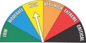
The Field/Grassland Fire Danger rating in Shelby County was reduced today (Thursday), from the “Extreme,” to “High” category. The rating is in effect until the next update on Monday. Emergency management officials warn conditions will still support large fire growth, and resistance to firefighting efforts. Be sure to call 712-755-2124 if you plan to conduct an outdoor burn, and contact your local Fire Chief prior to igniting.