
The month of June turned out to be a little cooler and a lot drier than normal, in Atlantic. Weather data compiled at the KJAN Studios (the official National Weather Service reporting site for Atlantic), show the Average High for the month (79.3-degrees), was 3.4-degrees cooler than the norm, and the Average Low was slightly cooler (58.1 degrees), than the normal 58.8 degrees. Rainfall for the month amounted to 2.87 inches, or some 2.11 inches less than the norm.
Our hottest days were the 29th and 30th, at 94 and 92 degrees, respectively. The coolest morning was on the 12th, when we bottomed out at 43. The most amount of rain (.64″) fell on the 22nd. Looking ahead to July: The typical monthly High is 85.8 degrees, while the Low is 63.1. Rainfall on average, is 4.62 inches.
Today: Partly cloudy. High 91. S @ 10-15 mph.
Tonight: P/Cldy w/scattered showers & thunderstorms. Low 74. S @ 5-10.
Tomorrow: P/Cldy to Cloudy w/scatt. shwrs & tstrms. High 87. S @ 10.
Wed./Thu.: P/Cldy to Cldy w/scatt. shwrs & tstrms. Highs both days around 87.
Sunday’s High in Atlantic was 92. Out Low this morning 73. Last year on this date, the High in Atlantic was 82 and the Low was 58. The Record High for July 1st in Atlantic was 104 in 1938. The Record Low was 45 in 1930, 1951 & 1995.
The heat and humidity will continue today, with temperatures rising from morning lows only in the 70s to reach the 90s by this afternoon. Heat index values will approach 105 degrees across much of Iowa and heat advisories are in effect statewide. Please take appropriate measures if you are outside today, and remember to look before you lock! Make sure there are no children or animals left in your vehicle! 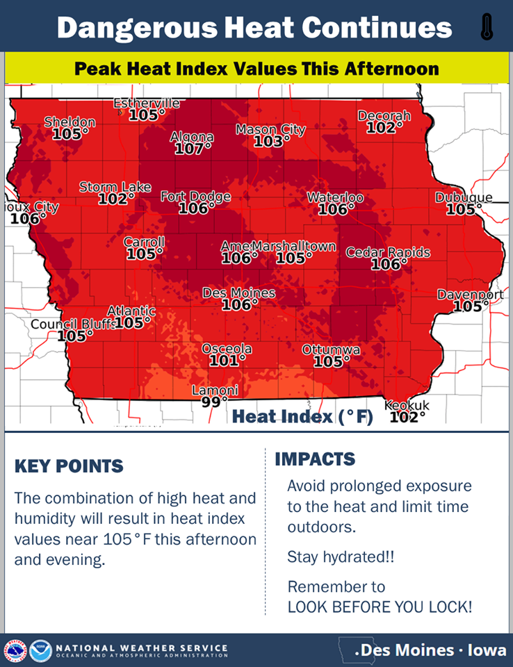
Today: Sunny, with a high near 91. Heat index values as high as 101. South southwest wind 6 to 9 mph. **HEAT ADVISORY from 11-a.m. until 9-p.m.**
Tonight: Mostly clear, with a low around 71. South wind around 6 mph.
Monday: Mostly sunny, with a high near 88. Southwest wind 3 to 8 mph.
Tuesday: A 20 percent chance of showers and thunderstorms after 1pm. Mostly sunny, with a high near 88.
Tuesday Night: A 30 percent chance of showers and thunderstorms. Mostly cloudy, with a low around 70.
Wednesday: A 30 percent chance of showers and thunderstorms. Partly sunny, with a high near 86.
Saturday’s High in Atlantic was 94. Our Low 74. Last year on this date, the High was 89 and the Low was 68. The Record High for this date in Atlantic, was 101 in 1933. The Record Low was 43 in 1940.
328 AM CDT Sun Jun 30 2019 For all but the far west/southwest counties: A HEAT ADVISORY NOW IN EFFECT FROM 11 AM THIS MORNING TO 9 PM CDT THIS EVENING FOR CASS AND MOST OF THE KJAN LISTENING AREA…(previously it was set to go into effect at 1-p.m. today). For Monona-Harrison-Shelby-Pottawattamie-Mills-Montgomery-Fremont-Page Counties, the Advisory will begin at 1-p.m..
* TEMPERATURE…Highs in the low to mid 90s, with peak heat index values around 105 degrees.
* IMPACTS…Heat illnesses are possible for those active outdoors, in homes without air conditioning, or those susceptible to heat illnesses such as children and the elderly.
PRECAUTIONARY/PREPAREDNESS ACTIONS…
A Heat Advisory means that a period of hot temperatures is expected. The combination of hot temperatures and high humidity will combine to create a situation in which heat illnesses are possible. Drink plenty of fluids, stay in an air-conditioned
room, stay out of the sun, and check up on relatives and neighbors.
Take extra precautions, if you work or spend time outside. When possible, reschedule strenuous activities to early morning or evening. Know the signs and symptoms of heat exhaustion and heat stroke. Wear light weight and loose fitting clothing when
possible and drink plenty of water.
To reduce risk during outdoor work, the occupational safety and health administration recommends scheduling frequent rest breaks in shaded or air conditioned environments. Anyone overcome by heat should be moved to a cool and shaded location. Heat stroke is an emergency, call 9 1 1.
A Heat Advisory remains in effect until 9-p.m. for all but the eastern third of Iowa, today (Saturday). Another HEAT ADVISORY will be in effect Sunday for the same time frame (1-p.m. to 9-p.m.).
Highs will be in the lower-to mid-90’s Sunday, with peak heat index values of 103-to near 110 degrees.
Heat illnesses are possible for those active outdoors, in home without air conditioning, or those susceptible to heat illnesses, such as children and the elderly.
A Heat Advisory means that a period of hot temperatures is expected. The combination of hot temperatures and high humidity will combine to create a situation in which heat illnesses are possible. Drink plenty of fluids, stay in an air-conditioned
room, stay out of the sun, and check up on relatives and neighbors.
Take extra precautions, if you work or spend time outside. When possible, reschedule strenuous activities to early morning or evening. Know the signs and symptoms of heat exhaustion and heat stroke. Wear light weight and loose fitting clothing when
possible and drink plenty of water.
To reduce risk during outdoor work, the occupational safety and health administration recommends scheduling frequent rest breaks in shaded or air conditioned environments. Anyone overcome by heat should be moved to a cool and shaded location. Heat stroke is an emergency, call 9 1 1.
Today: **HEAT ADVISORY from 1-p.m. Until 9-p.m.** Areas of fog this morning; Partly cloudy. High 93. Heat Index around 102. S @ 10-15.
Tonight: P/Cldy. Low 73. S @ 5-10.
Tomorrow: P/Cldy. High near 93. S @ 10-15. Heat Index around 101.
Monday: P/Cldy w/isolated thundershowrs. High 90.
Tuesday: P/Cldy w/scattered thundershowers. High around 87.
Yesterday’s High in Atlantic was 89. Our Low this morning 71. Last year on this date our High was 92 and the Low was 75. The record High in Atlantic on this date was 102 in 1934. The Record Low was 46 in 1950.
THE NATIONAL WEATHER SERVICE HAS ISSUED A HEAT ADVISORY FOR MOST OF IOWA FROM 1-P.M. SATURDAY UNTIL 9-P.M., INCLUDING THE ENTIRE KJAN LISTENING AREA.
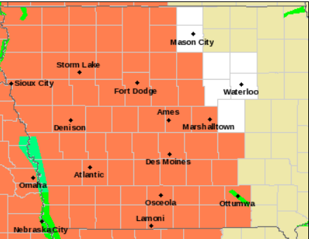
Heat Advisory for all counties in orange.
* TEMPERATURE…Highs should reach the lower 90s with peak afternoon heat indicies from the upper 90s to as high as 105 degrees.
* IMPACTS…Heat illnesses are possible for those active outdoors or those susceptible to heat illnesses such as children and the elderly.
PRECAUTIONARY/PREPAREDNESS ACTIONS…
A Heat Advisory means that a period of hot temperatures is expected. The combination of hot temperatures and high humidity will combine to create a situation in which heat illnesses are possible. Drink plenty of fluids, stay in an air-conditioned
room, stay out of the sun, and check up on relatives and neighbors.
Take extra precautions, if you work or spend time outside. When possible, reschedule strenuous activities to early morning or evening. Know the signs and symptoms of heat exhaustion and heat stroke. Wear light weight and loose fitting clothing when possible and drink plenty of water.
To reduce risk during outdoor work, the occupational safety and health administration recommends scheduling frequent rest breaks in shaded or air conditioned environments. Anyone overcome by heat should be moved to a cool and shaded location. Heat stroke is an emergency, call 9 1 1.
In an update to their previous report, the National Weather Service in Des Moines says the hottest weather of the year thus far will impact Iowa through the upcoming weekend. High temperatures will top out in the upper 80s to mid-90s each day, with overnight lows only in the 70s each night. Heat index values will approach 100°F each afternoon/evening, making this easily the hottest stretch of weather experienced since last summer. The hottest temps are likely in the western half of Iowa. A Heat Advisory is in effect for three counties in Northwest Iowa.
 The latest information puts the Heat Index (how it feels) in Atlantic, Council Bluffs and Sheldon at around 103 degrees, Sioux City 105, 101 in Carroll, Des Moines and Ft. Dodge, 102 in Algona and Ames, and 100 in Estherville. Other locations will have a heat index of 95-to 97-degrees. If planning outdoor activities, avoid prolonged exposure to the heat and be HEAT SMART.
Heat is the #1 weather-related killer in the United States! Here are a few tips on staying safe during episodes of dangerously hot weather:
For more information, check the National Weather Service’s Heat Safety page.
Today: Partly cloudy w/isolated showers & thunderstorms possible. High 91. Heat Index around 100.
S @ 10-20.
Tonight: P/Cldy. Low 74. S @ 5-10.
Tomorrow: P/Cldy. High near 93. S @ 10-20. Heat Index around 101.
Sunday: P/Cldy. High 93.
Monday: P/Cldy w/scattered thundershowers. High around 90.
Yesterday’s High in Atlantic was 89. Our Low was 73. Last year on this date our High was 85 and the Low was 64. The record High in Atlantic on this date was 103 in 1936. The Record Low was 50 in 1896 & 2006.


