Today: Patchy fog this morning; Partly cloudy with scattered showers & thunderstorms later this afternoon. High near 90. S @ 5-10 mph.
Tonight: P/cldy to cloudy w/scattered shwrs & tstrms ending. Low around 70. S @ 5.
Tomorrow: P/Cldy w/scattered afternoon shwrs & tstrms. High around 90. S @ 5-10.
Tom. Night: P/Cldy. Low around 70. A chance of showers before sunrise.
Saturday: P/Cldy to Cldy w/scattered shwrs & tstrms. Highs around 86.
Sunday: P/Cldy to Cldy w/scattered shwrs & tstrms. High 83.
Yesterday’s High in Atlantic was 89. We received .23” rain yesterday and last night. Our Low this morning, 66. Last year on this date our High was 91 and the Low was 68. The record High in Atlantic on this date was 111 in 1936. The Record Low was 41 in 1967.
Today: Partly cloudy to cloudy w/scattered showers & thunderstorms this morning & again later this afternoon. High 87. Winds variable at 5-10 mph.
Tonight: Partly- to Mostly cloudy w/scattered shwrs & tstrms. Low 70.
Tomorrow: P/Cldy to Cldy w/scattered morning & late afternoon shwrs & tstrms. High 89. SE @ 5-10.
Friday: P/Cldy to Cldy w/scattered shwrs & tstrms. Highs around 85.
Saturday: P/Cldy to Cldy w/scattered shwrs & tstrms. High 82.
Yesterday’s High in Atlantic was 91. Our Low this morning, 69. Last year on this date our High was 91 and the Low was 68. The record High in Atlantic on this date was 107 in 1936. The Record Low was 43 in 1967 & 1968.
Special Weather Statement
National Weather Service Des Moines IA
430 PM CDT Tue Jul 2 2019
IAZ026>028-033>039-044>050-057>062-070-022330-
Franklin-Butler-Bremer-Sac-Calhoun-Webster-Hamilton-Hardin-Grundy-
Black Hawk-Crawford-Carroll-Greene-Boone-Story-Marshall-Tama-
Audubon-Guthrie-Dallas-Polk-Jasper-Poweshiek-Cass-
Including the cities of Hampton, Parkersburg, Clarksville,
Shell Rock, Greene, Aplington, Allison, Dumont, Waverly,
Sac City, Lake View, Odebolt, Wall Lake, Schaller, Early,
Rockwell City, Manson, Lake City, Pomeroy, Fort Dodge,
Webster City, Iowa Falls, Eldora, Ackley, Grundy Center,
Reinbeck, Conrad, Dike, Wellsburg, Waterloo, Cedar Falls,
Denison, Carroll, Jefferson, Boone, Ames, Marshalltown, Tama,
Toledo, Traer, Dysart, Gladbrook, Audubon, Exira, Guthrie Center,
Panora, Bayard, Casey, Perry, Waukee, Adel, Des Moines, Newton,
Grinnell, and Atlantic
430 PM CDT Tue Jul 2 2019
…Strong Thunderstorms Expected Late This Afternoon…
Scattered thunderstorms will continue over portions of central
Iowa late this afternoon. Most of the storms will remain below
severe limits, but isolated storms may be strong to severe with
large hail and damaging winds.
People with outdoor activities should monitor the weather closely
for rapidly changing conditions as some of the storms have been
intensifying rather quickly.
Pottawattamie IA-Harrison IA-Shelby IA-Washington NE-Douglas NE-
421 PM CDT Tue Jul 2 2019

...A SEVERE THUNDERSTORM WARNING REMAINS IN EFFECT UNTIL 500 PM CDT
FOR NORTHWESTERN POTTAWATTAMIE...SOUTHEASTERN HARRISON...SOUTHWESTERN
SHELBY...SOUTHEASTERN WASHINGTON AND NORTHEASTERN DOUGLAS COUNTIES...

At 420 PM CDT, a severe thunderstorm was located 6 miles south of
Missouri Valley, or 15 miles northeast of Omaha, moving northeast at
15 mph.

HAZARD...70 mph wind gusts and half dollar size hail.

SOURCE...Trained weather spotters.

IMPACT...Hail damage to vehicles is expected. Expect considerable
         tree damage. Wind damage is also likely to mobile homes,
         roofs, and outbuildings.

Locations impacted include...
Missouri Valley, Fort Calhoun, Shelby, Persia, Portsmouth, Tennant
and Hitchcock Nature Center.

This includes the following highways...
 Interstate 29 between mile markers 63 and 74.
 Interstate 80 in Iowa between mile markers 27 and 29.

PRECAUTIONARY/PREPAREDNESS ACTIONS...

For your protection move to an interior room on the lowest floor of a
building.

This storm is producing large hail and widespread wind damage. SEEK
SHELTER NOW inside a sturdy structure and stay away from windows.
Pottawattamie IA-Harrison IA-Shelby IA-Washington NE-Douglas NE-
421 PM CDT Tue Jul 2 2019
…A SEVERE THUNDERSTORM WARNING REMAINS IN EFFECT UNTIL 500 PM CDT
FOR NORTHWESTERN POTTAWATTAMIE…SOUTHEASTERN HARRISON…SOUTHWESTERN
SHELBY…SOUTHEASTERN WASHINGTON AND NORTHEASTERN DOUGLAS COUNTIES…
At 420 PM CDT, a severe thunderstorm was located 6 miles south of
Missouri Valley, or 15 miles northeast of Omaha, moving northeast at
15 mph.
HAZARD…70 mph wind gusts and half dollar size hail.
SOURCE…Trained weather spotters.
IMPACT…Hail damage to vehicles is expected. Expect considerable
tree damage. Wind damage is also likely to mobile homes,
roofs, and outbuildings.
Locations impacted include…
Missouri Valley, Fort Calhoun, Shelby, Persia, Portsmouth, Tennant
and Hitchcock Nature Center.
This includes the following highways…
Interstate 29 between mile markers 63 and 74.
Interstate 80 in Iowa between mile markers 27 and 29.
Today: Partly cloudy to cloudy w/scattered showers & thunderstorms, mainly later this afternoon. High 87. SW @ 10-15.
Tonight: Partly- to Mostly cloudy w/scattered shwrs & tstrms. Low 70.
Tomorrow: P/Cldy to Cldy w/scattered shwrs & tstrms. High 88. Variable breeze @ 5-10.
Thu./Fri.: P/Cldy to Cldy w/scattered shwrs & tstrms. Highs around 87.
Yesterday’s High in Atlantic was 89. Our Low this morning, 71. Last year on this date our High was 84 and the Low was 61. The record High in Atlantic on this date was 102 in 1911. The Record Low was 45 in 1924 & 1959.
(Radio Iowa) — While tornadoes can strike during any month of the year in Iowa, the peak months are April, May and June. Now that we’re into July, the risks diminish slightly.
Meteorologist Brooke Hagenhoff, at the National Weather Service, says Iowa had zero tornadoes during April and didn’t see this year’s first twister touch down until May 22nd. “We got off to a quicker start after that. We had quite a few tornadoes toward the end of May, although those were all relatively short-lived and weak,” Hagenhoff says. “For the month of May, we had 25 tornadoes and for June, just eight tornadoes across the state of Iowa.”
We’re never out of the woods with tornadoes, so she urges people to remain vigilant, though at the moment, Iowa is well behind normal for the potentially-deadly wind storms. “Each year can fluxuate. Our average for the state of Iowa is usually around 48 tornadoes,” Hagenhoff says. “We’re sitting at 33 so far here for 2019.”
The past few years, Iowa had above-average numbers of tornadoes, with 55 in 2017 and 69 last year. July 19th of last year brought an outbreak of very large, destructive tornadoes to Marshalltown, Pella and Bondurant. Tornadoes have hit Iowa during the fall, too. For example, a twister tore through Belmond in October of 1966 and Stratford in November of 2005.
The month of June turned out to be a little cooler and a lot drier than normal, in Atlantic. Weather data compiled at the KJAN Studios (the official National Weather Service reporting site for Atlantic), show the Average High for the month (79.3-degrees), was 3.4-degrees cooler than the norm, and the Average Low was slightly cooler (58.1 degrees), than the normal 58.8 degrees. Rainfall for the month amounted to 2.87 inches, or some 2.11 inches less than the norm.
Our hottest days were the 29th and 30th, at 94 and 92 degrees, respectively. The coolest morning was on the 12th, when we bottomed out at 43. The most amount of rain (.64″) fell on the 22nd. Looking ahead to July: The typical monthly High is 85.8 degrees, while the Low is 63.1. Rainfall on average, is 4.62 inches.
Today: Partly cloudy. High 91. S @ 10-15 mph.
Tonight: P/Cldy w/scattered showers & thunderstorms. Low 74. S @ 5-10.
Tomorrow: P/Cldy to Cloudy w/scatt. shwrs & tstrms. High 87. S @ 10.
Wed./Thu.: P/Cldy to Cldy w/scatt. shwrs & tstrms. Highs both days around 87.
Sunday’s High in Atlantic was 92. Out Low this morning 73. Last year on this date, the High in Atlantic was 82 and the Low was 58. The Record High for July 1st in Atlantic was 104 in 1938. The Record Low was 45 in 1930, 1951 & 1995.
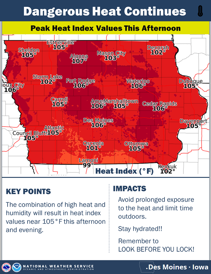
The heat and humidity will continue today, with temperatures rising from morning lows only in the 70s to reach the 90s by this afternoon. Heat index values will approach 105 degrees across much of Iowa and heat advisories are in effect statewide. Please take appropriate measures if you are outside today, and remember to look before you lock! Make sure there are no children or animals left in your vehicle!