
The (podcast) Freese-Notis/Weather.Net forecast for the KJAN listening area, and weather information for Atlantic…

Podcast: Play in new window | Download (835.4KB)
Subscribe: RSS
Today: Sunny, with a high near 76. Breezy, with a south wind 9 to 17 mph, with gusts as high as 24 mph.
Tonight: Mostly clear, with a low around 51. South southeast wind 7 to 11 mph.
Thursday: Sunny, with a high near 80. Breezy, with a south wind 8 to 18 mph, with gusts as high as 28 mph.
Thursday Night: Mostly clear, with a low around 57. South southeast wind 10 to 13 mph, with gusts as high as 20 mph.
Friday: A 30 percent chance of showers and thunderstorms before 1pm. Partly sunny, with a high near 80. Windy, with a south wind 14 to 23 mph, with gusts as high as 34 mph.
Friday Night: Partly cloudy, with a low around 50.
Saturday: Sunny, with a high near 67.
The (podcast) Freese-Notis/Weather.Net forecast for the KJAN listening area, and weather information for Atlantic…
Podcast: Play in new window | Download (969.2KB)
Subscribe: RSS
Due to the Federal government shutdown, the USDA National Agriculture Statistics Service (NASS) has not completed the weekly crop progress and condition report that is released weekly during the growing season. Iowa Secretary of Agriculture Bill Northey issued a statement Monday on harvest progress, however.
Northey said “Unfortunately due to the Federal government shutdown we will not have a crop progress report this week. In general, what I’m hearing from around the state is that many farmers were able to start harvesting before the wet weather moved in late last week. If we get several days of dry, warm weather this week as forecasted, that will help crops dry down and farmers will again be busy harvesting both corn and soybeans.”
State Climatologist Harry Hillaker, with the Iowa Department of Agriculture & Land Stewardship says weather-wise, the big news of the week was the severe weather impacting northwestern Iowa on Friday (4th) evening. Damage surveys are ongoing, however it would appear that this was Iowa’s largest tornado event for so late in the year since the outbreak of November 12, 2005. Tornado damage was reported from Woodbury, Plymouth, Cherokee and Buena Vista counties with large hail and high winds reported from an additional 15 counties across north central, southwest and central Iowa.
The past reporting week began with dry weather prevailing from Sunday (29th) through Wednesday (2nd) afternoon. Thunderstorms developed over western Iowa late Wednesday and spread across far northern and far southern Iowa on Thursday (3rd) morning. Thunderstorms brought widespread moderate to heavy rain from west central into east central Iowa late Thursday into Friday afternoon with a few reports of large hail and high wind in central Iowa. Friday evening’s storms were mostly confined to about the northwest one-half of the state with the heaviest rains centered upon Worth, Mitchell and Floyd counties. Weekly rain totals varied from only 0.02 inches at Fairfield to 5.19 inches near Colwell in Floyd County.
The statewide average precipitation was 1.19 inches while normal for the week is 0.69 inches. This was Iowa’s wettest week in 14 weeks (late June). Meanwhile, unseasonably warm and humid air dominated the state from Monday (30th) through Friday (4th) with afternoon highs reaching into the 80’s each day over much of Iowa. Sunday (29th) and Saturday (5th) at the beginning and end of the period brought seasonal temperatures. Temperature extremes varied from afternoon highs of 88 degrees at Sioux City on Wednesday (2nd) and at Donnellson, Fort Madison and Keokuk on Friday (4th) to Saturday (5th) morning lows of 37 degrees at Hawarden, Le Mars, Rock Rapids, Sibley and Sioux Center. Temperatures for the week as a whole averaged 7.7 degrees above normal.
343 AM CDT TUE OCT 8 2013
EARLY THIS MORNING…CLEAR. SOUTH WIND 5 TO 10 MPH.
TODAY…SUNNY…BREEZY. HIGH IN THE UPPER 70S. SOUTH WIND 10 TO 20 MPH INCREASING TO 20 TO 25 MPH IN THE AFTERNOON. GUSTS UP TO 35 MPH.
TONIGHT…MOSTLY CLEAR. LOW IN THE LOWER 50S. SOUTH WIND 10 TO 15 MPH WITH GUSTS TO AROUND 25 MPH.
WEDNESDAY…MOSTLY SUNNY. BREEZY. HIGH IN THE UPPER 70S. SOUTH WIND 10 TO 20 MPH WITH GUSTS TO AROUND 30 MPH.
WEDNESDAY NIGHT AND THURSDAY…MOSTLY CLEAR. BREEZY. LOW IN THE LOWER 50S. HIGH IN THE UPPER 70S. SOUTH WIND 5 TO 20 MPH WITH GUSTS TO AROUND 30 MPH.
THURSDAY NIGHT…PARTLY CLOUDY. LOW IN THE UPPER 50S.
FRIDAY AND FRIDAY NIGHT…PARTLY CLOUDY. A 30 PERCENT CHANCE OF THUNDERSTORMS. BREEZY. HIGH IN THE MID 70S. LOW IN THE LOWER 50S.
Officials with the Iowa Storm Chasing Network said today (Monday), the Wayne, NE tornado measured nearly 1.4-miles wide, and is the widest tornado to ever occur in the month of October since 1950. The National Weather Service said Sunday, the tornado was rated an EF-4 with peak winds reaching 170mph.
It was on the ground for 19 miles and injured 15 people. The Weather Service says October tornadoes are unusual, but not unheard of. Last year, there were 41 tornadoes nationwide in October.
Shelby County Emergency Management Coordinator Bob Seivert says the Fire Danger index in the County will remain in the “Moderate” category through at least this Thursday, Oct. 10th. 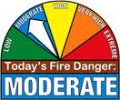 With winds expected to increase this week to around 30 miles per hour, Seivert says open burning should be avoided, especially on Tuesday.
The (podcast) Freese-Notis/Weather.Net forecast for the KJAN listening area, and weather information for Atlantic….
Podcast: Play in new window | Download (975.0KB)
Subscribe: RSS
(Updated 4:19-a.m.)
TODAY...SUNNY. MUCH WARMER. HIGH IN THE LOWER 70S. WEST WIND 5 TO 15 MPH.
TONIGHT…CLEAR. LOW IN THE MID 40S. SOUTH WIND 5 TO 10 MPH.
TUESDAY…MOSTLY SUNNY. BREEZY. HIGH IN THE MID 70S. SOUTH WIND 10 TO 15 MPH INCREASING TO 15 TO 25 MPH IN THE AFTERNOON.
TUESDAY NIGHT AND WEDNESDAY…MOSTLY CLEAR. LOW IN THE LOWER 50S. HIGH IN THE UPPER 70S. SOUTH WIND 10 TO 15 MPH WITH GUSTS TO AROUND 25 MPH.
WEDNESDAY NIGHT AND THURSDAY…MOSTLY CLEAR. LOW IN THE LOWER 50S. HIGH IN THE MID 70S.
THURSDAY NIGHT…PARTLY CLOUDY. LOW IN THE UPPER 50S.
FRIDAY…MOSTLY CLOUDY WITH A 40 PERCENT CHANCE OF THUNDERSTORMS. BREEZY. HIGH IN THE MID 70S.
FRIDAY NIGHT…PARTLY CLOUDY WITH A CHANCE OF SHOWERS AND ISOLATED THUNDERSTORMS. LOW IN THE LOWER 50S. CHANCE OF PRECIPITATION 30 PERCENT.
(Updated 5-a.m.)
Today: Rain. High near 48. W-NW wind at 10-25 mph. Chance of precipitation is 80%. New precipitation amounts between a tenth and quarter of an inch possible.
Tonight: Rain likely, mainly before midnight. Cloudy, then gradually becoming partly cloudy, with a low around 41. Northwest wind 10-20 mph. Chance of precipitation is 60%. New precipitation amounts of less than a tenth of an inch possible.
Monday: Mostly sunny, with a high near 69. West wind 5-10 mph.
Monday Night: Mostly clear, with a low around 46. South wind around 5 mph.
Tuesday: Sunny & breezy, with a high near 75. South wind 10-20 mph.
Tuesday Night: Mostly clear, with a low around 52.
Wednesday: Sunny & breezy, with a high near 77.


