
1146 AM CDT SUN JUN 29 2014
REST OF TODAY…MOSTLY CLOUDY. SCATTERED THUNDERSTORMS. SOME THUNDERSTORMS MAY BE SEVERE LATE IN THE AFTERNOON. HIGH IN THE MID 80S. SOUTH WIND 5 TO 15 MPH. CHANCE OF THUNDERSTORMS 50 PERCENT.
TONIGHT…NUMEROUS THUNDERSTORMS IN THE EVENING…THEN WIDESPREAD THUNDERSTORMS BEFORE MIDNIGHT. THUNDERSTORMS LIKELY AFTER MIDNIGHT. SOME THUNDERSTORMS MAY BE SEVERE UNTIL EARLY MORNING. LOW IN THE UPPER 60S. SOUTH WIND 5 TO 10 MPH. CHANCE OF THUNDERSTORMS 90 PERCENT.
MONDAY…THUNDERSTORMS LIKELY THROUGH MID MORNING…THEN THUNDERSTORMS IN THE LATE MORNING AND EARLY AFTERNOON. THUNDERSTORMS LIKELY LATE IN THE AFTERNOON. HIGH IN THE LOWER 80S. SOUTHWEST WIND 5 TO 15 MPH. CHANCE OF THUNDERSTORMS 80 PERCENT.
MONDAY NIGHT…MOSTLY CLEAR. LOW IN THE LOWER 60S. WEST WIND 5 TO 15 MPH.
TUESDAY…MOSTLY SUNNY. A SLIGHT CHANCE OF SHOWERS AND ISOLATED THUNDERSTORMS IN THE AFTERNOON. HIGH IN THE UPPER 70S. WEST WIND 10 TO 15 MPH. CHANCE OF PRECIPITATION 20 PERCENT.
TUESDAY NIGHT AND WEDNESDAY…MOSTLY CLOUDY. LOW IN THE UPPER 50S. HIGH IN THE UPPER 70S.
Rainfall in Atlantic (24-hour total 7-a.m. Saturday 6/28 thru 6-a.m. Sunday, June 29th)= .2″. Saturday’s High was85. The 24-hour low 65.
1.5 miles south of Avoca=.55″; Shenandoah=.03″;
The National Weather Service says significant severe weather is possible both today and Monday over a large part of Iowa. The weather both days may produce some tornadoes…very large hail…and widespread damaging winds. There will also be the potential for locally heavy rainfall today and Monday.
Monday may also bring a widespread significant wind event to the area in the late morning and afternoon to evening hours. Be prepared…stay alert to changing conditions today and Monday. Monitor forecasts for possible watches and warnings. Review your severe weather safety procedures and move to a place of safety if a warning is issued for your area.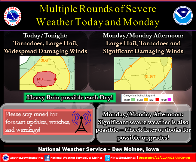
Today – Partly sunny with a 60% chance of showers and thunderstorms, mainly after 4pm. Some storms could be severe, with large hail, damaging winds, and heavy rain. High near 87. South southwest wind 5 to 10 mph. New rainfall amounts between a half and three quarters of an inch possible.
Tonight – A 90% chance of showers and thunderstorms. Some storms could be severe, with large hail, damaging winds, and heavy rain. Low around 67. South wind 5 to 10 mph. New rainfall amounts between three quarters and one inch possible.
Monday – Cloudy with an 80% chance of showers and thunderstorms, mainly before 1pm. High near 83. South wind 10 to 15 mph becoming westerly during the afternoon. New rainfall amounts between a half and three quarters of an inch possible.
Monday Night – Mostly clear, with a low around 61.
Tuesday – Mostly sunny & breezy with a 20% chance of showers and thunderstorms after 1pm. High near 79. West winds 10 to 15 mph.
Tuesday Night – Partly cloudy, with a low around 59.
Wednesday – Mostly sunny, with a high near 75.
1035 PM CDT SAT JUN 28 2014

THE NATIONAL WEATHER SERVICE IN OMAHA HAS ISSUED A

* SEVERE THUNDERSTORM WARNING FOR...
  WESTERN POTTAWATTAMIE COUNTY IN SOUTHWEST IOWA...
  SOUTHEASTERN WASHINGTON COUNTY IN EAST CENTRAL NEBRASKA...
  NORTHEASTERN DOUGLAS COUNTY IN EAST CENTRAL NEBRASKA...

* UNTIL 1100 PM CDT

* AT 1035 PM CDT...A SEVERE THUNDERSTORM WAS LOCATED NEAR FORT
  CALHOUN...OR 8 MILES NORTH OF OMAHA...MOVING EAST AT 25 MPH.

  HAZARD...QUARTER SIZE HAIL.

  SOURCE...RADAR INDICATED.

  IMPACT...DAMAGE TO VEHICLES IS EXPECTED.

* LOCATIONS IMPACTED INCLUDE...
  NORTHEASTERN OMAHA...COUNCIL BLUFFS...UNDERWOOD...FORT CALHOUN...
  CARTER LAKE...BENNINGTON...CRESCENT...MCCLELLAND...WILSON ISLAND
  STATE PARK...NARROWS RIVER PARK AND HITCHCOCK NATURE CENTER.

THIS INCLUDES THE FOLLOWING HIGHWAYS...
 HIGHWAY 75 IN NEBRASKA BETWEEN MILE MARKERS 91 AND 108.
 INTERSTATE 29 BETWEEN MILE MARKERS 47 AND 50...AND BETWEEN MILE
MARKERS 54 AND 68.
 INTERSTATE 80 IN IOWA BETWEEN MILE MARKERS 3 AND 20.

PRECAUTIONARY/PREPAREDNESS ACTIONS...

FOR YOUR PROTECTION MOVE TO AN INTERIOR ROOM ON THE LOWEST FLOOR OF A
BUILDING.
THE NATIONAL WEATHER SERVICE HAS CANCELLED SEVERE THE THUNDERSTORM WATCH WHICH HAD BEEN IN EFFECT FOR ADAIR DALLAS GUTHRIE MADISON RINGGOLD AND UNION COUNTIES IN THE KJAN LISTENING AREA.
ADDITIONAL PERIODS OF THUNDERSTORMS ARE EXPECTED SUNDAY INTO MONDAY. THERE IS A MODERATE RISK OF SEVERE THUNDERSTORMS FOR SUNDAY AND SUNDAY NIGHT. DAMAGING WIND…LARGE HAIL AND A FEW TORNADOES ARE ALL POSSIBLE SUNDAY. SUNDAY NIGHT THE THREAT WILL MAINLY BE DAMAGING WIND. VERY HEAVY RAINFALL WILL OCCUR WITH STORMS AND FLASH FLOODING WILL BE POSSIBLE.
ADDITIONAL SEVERE THUNDERSTORMS ARE POSSIBLE MONDAY WITH DAMAGING WIND THE MAIN THREAT. HEAVY RAINFALL IS ALSO LIKELY WITH THUNDERSTORMS.
Multiple rounds of severe weather are expected starting this (Saturday) afternoon and going through Monday for Iowa. Sunday afternoon looks to be the biggest threat. Please stay weather aware this weekend, especially if you are outdoors!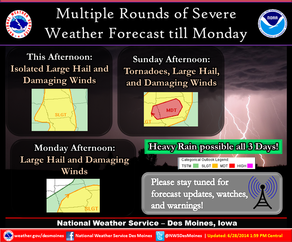
210 PM CDT SAT JUN 28 2014
SEVERE THUNDERSTORM WATCH 365 IS IN EFFECT UNTIL 900 PM CDT
FOR THE FOLLOWING LOCATIONS…IOWA COUNTIES INCLUDED ARE
ADAIR APPANOOSE BLACK HAWK BOONE BREMER BUTLER CERRO GORDO CHICKASAW CLARKE DALLAS DAVIS DECATUR FLOYD FRANKLIN GREENE GRUNDY GUTHRIE HAMILTON HANCOCK HARDIN HOWARD HUMBOLDT JASPER KOSSUTH LUCAS MADISON MAHASKA MARION MARSHALL MITCHELL MONROE POLK POWESHIEK RINGGOLD STORY TAMA UNION WAPELLO WARREN WAYNE WEBSTER WINNEBAGO WORTH WRIGHT.
KJAN Studios on North edge of Atlantic- .38″
Massena (Ardell McCunn)- .48″
Today: Showers and thunderstorms, mainly after 1pm. High near 79. Breezy, with a south wind 15 to 20 mph, with gusts as high as 25 mph. Chance of precipitation is 90%. New rainfall amounts between a half and three quarters of an inch possible.
Tonight: Showers and thunderstorms likely, mainly before 4am. Mostly cloudy, with a low around 68. South wind 10 to 15 mph. Chance of precipitation is 70%. New rainfall amounts between a quarter and half of an inch possible.
Sunday: A slight chance of showers and thunderstorms before 7am, then a slight chance of showers and thunderstorms after 1pm. Mostly sunny, with a high near 90. Heat index values as high as 101. Breezy, with a south southwest wind 10 to 15 mph. Chance of precipitation is 20%.
Sunday Night: Showers and thunderstorms. Some storms could be severe, with heavy rain. Low around 69. South wind 10 to 15 mph. Chance of precipitation is 80%. New rainfall amounts between three quarters and one inch possible.
Monday: Showers and thunderstorms likely. Mostly cloudy, with a high near 84. South wind around 10 mph becoming west northwest in the afternoon.
Tuesday: Mostly sunny, with a high near 79.
Wednesday: Mostly sunny, with a high near 78.

Podcast: Play in new window | Download (397.3KB)
Subscribe: RSS


