
Today: Partly cloudy to cloudy w/light snow late. High 16. E @ 10 mph.
Tonight: Cloudy early w/light snow ending (less than 1/2 total, expected). Becoming P/Cldy overnight. Low 0. N @ 5-10.
Saturday: Mo. Cldy w/a chance of light snow late, High 24. E @ 10.
Saturday night: A 90% chance of snow. Low 17.
Sunday: A 40% chance of snow. (2-4″ possible total). High 28.
Monday: P/Cldy. High around 20.
Thursday’s High in Atlantic was 34. Our Low through 5:15-a.m. today was 0. Last year on this date, the High in Atlantic was 44 and the Low was 10. The All-time Record High in Atlantic on Feb. 15th was 72 in 1921. The Record Low was -31 in 1905.
Today:Partly cloudy to cloudy. High this morning around 35, w/temps falling during the day. SE winds @ 10 mph becoming NW @ 15-20 this afternoon.
Tonight: P/Cloudy w/decreasing winds. Low 0.
Tomorrow: Mostly cloudy w/light snow in the afternoon. High 18. E @ 5-10.
Saturday:P/Cldy to Cldy w/light snow late. High 24.
Sunday: Mo. Cldy w/snow. High 26.
Yesterday’s High in Atlantic was 36. Our Low this morning 4. Last year on this date our High was 44 and the Low was 32. The record High in Atlantic on this date was 68 in 1934. The Record Low was -20 in 1936.
Today: Mostly sunny this morning; Partly cloudy this afternoon. High 32, SE @ 10-15.
Tonight: P/Cloudy. Low 28. S @ 5-10.
Tomorrow: P/Cldy to Cldy. High around 35 w/temps falling during the day. NW @ 15-30. Friday: P/Cldy to Cldy w/light snow in the afternoon. High 18. Saturday:P/Cldy to Cldy w/a chance of snow in the afternoon. High 24.
Yesterday’s High in Atlantic was 24. Our Low this morning 1. Last year on this date our High was 38 and the Low was 15. The record High in Atlantic on this date was 63 in 1934. The Record Low was -30 in 1905.
Early this morning: A 40 percent chance of snow before 5am. Cloudy, with a steady temperature around 25. Northwest wind around 15 mph, with gusts as high as 21 mph. Total nighttime snow accumulation of around an inch possible.
Today: **Winter Weather Advisory until 6-p.m.** Patchy blowing snow between 10am and 5pm. Mostly cloudy through mid morning, then gradual clearing, with a high near 24. Wind chill values as low as 5. Windy, with a west northwest wind 16 to 22 mph, with gusts as high as 33 mph.
Tonight: Mostly clear, with a low around 5. Wind chill values as low as -5. Blustery, with a west northwest wind 11 to 16 mph becoming west 5 to 10 mph after midnight. Winds could gust as high as 23 mph.
Wednesday: Mostly sunny, with a high near 33. Wind chill values as low as -5. South southeast wind 5 to 14 mph, with gusts as high as 18 mph.
Thursday: Mostly cloudy, with a high near 30. Blustery.
Friday: A 30 percent chance of snow, mainly before noon. Partly sunny, with a high near 15.
Yesterday’s High in Atlantic was 27. We received 2.9 inches of snow yesterday into early this morning (.12″ liquid value). Our Low this morning 22. Last year on this date our High was 22 and the Low was 1. The record High in Atlantic on this date was 72 in 1990. The Record Low was -24 in 1986 & 1988.
Today:**Winter Weather Advisory 9-a.m. Today until 6-p.m. Tuesday** Cloudy w/areas of fog, freezing drizzle and snow. High 24. E @ 10-15. (Little or no ice accumulation expected)
Tonight: Cloudy. Snow ending late (3-5” total). Low 15. N @ 10-20.
Tuesday: P/Cldy to Cldy, windy & colder. High 18. NW @ 20-25. WC around 5.
Wednesday: P/Cldy to Cldy. High around 30.
Thursday: P/Cldy to Cldy w/flurries. High 26.
Yesterday’s High in Atlantic was 29. Our Low this morning 22. We received 1.6-inches of snow yesterday for a total of 3.6”. Last year on this date our High was 22 and the Low was -4. The record High in Atlantic on this date was 64 in 1951 & 1999. The Record Low was -26 in 1899.
Today:**Winter Weather Advisory until 3-p.m.** Snow and freezing drizzle before noon, then a chance of freezing drizzle between noon and 3pm. High near 30. Southeast wind 5 to 10 mph becoming light south southeast and gusting to near 20. Little or no ice accumulation expected. New snow accumulation of 1 to 2 inches possible.
Tonight: Cloudy, with a low around 20. East northeast wind 5 to 108 mph.
Monday: Snow, possibly mixed with freezing rain. High near 29. E winds @ 15-25 mph. Wind chill values as low as 10. New ice accumulation of less than a 0.1 of an inch possible. New snow accumulation of less than one inch possible.
Monday Night: Snow, possibly mixed with freezing rain. Low around 22. East winds @ 10-25 becoming NW after midnight. New ice accumulation of less than a 0.1 of an inch possible. New snow accumulation of 1 to 2 inches possible.
Tuesday: A 20 percent chance of snow before noon. Patchy blowing snow between 11am and 2pm. Partly sunny, with a high near 28. Blustery.
Wednesday: Mostly sunny, with a high near 31.
Yesterday’s High in Atlantic was 26. Our Low was 2. We received 1.6-inches of snow overnight through 6-a.m. Today, here at KJAN. Last year on this date our High was 11 and the Low was 1. The record High in Atlantic on this date was 72 in 1999. The Record Low was -24 in 1905.
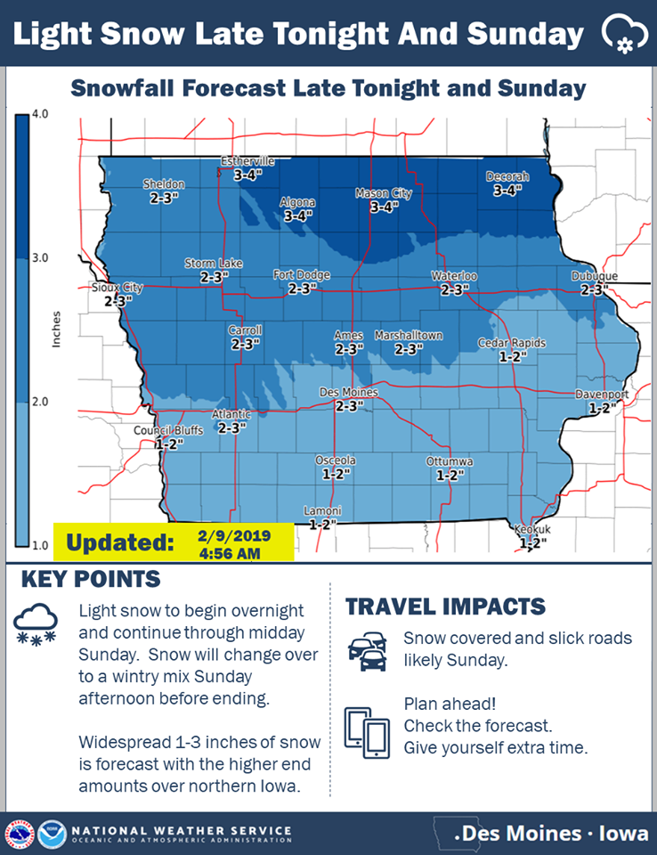
The National Weather Service this (Saturday) morning, said they are still tracking two winter systems to impact Iowa through Tuesday. The first one still to bring light snow to much of Iowa late tonight through Sunday. Some light freezing drizzle may mix with with the snow as precipitation ends late Sunday.
A stronger winter storm system is then slated to impact Iowa Monday into Tuesday. Precipitation is expected to spread across Iowa Monday as a light wintry mix, then change to snow Monday evening and continue into Tuesday. Moderate to heavy accumulations of snow are more likely across the northern half of the state. Uncertainty still high with snow amounts given uncertainty in the track and strength of this system. Northwest winds will increase across the state Tuesday and be strong and gusty through the day into Tuesday evening. This will allow for blowing and drifting snow. Travel may be difficult across the state Tuesday with snow-packed roads and significantly reduced visibilities possible.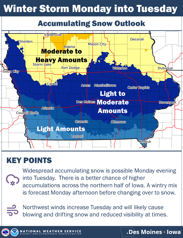
click on the graphic to enlarge
Today: Partly cloudy-to cloudy. High 26. SE @ 10-20. Wind Chill as low as -10.
Tonight: Mostly Cloudy w/light snow developing late. Low 22.. SE @ 5. WC 5.
Tomorrow: Cloudy w/snow (2-4” total possible). High 28. E @ 10-15.
Monday: Mo. Cldy w/a chance of afternoon snow. High around 30.
Tuesday: Cldy w/snow in the morning. High 28.
Yesterday’s High in Atlantic was 13. Our Low was -5. Last year on this date our High was 14 and the Low was 1. The record High in Atlantic on this date was 59 in 1954, 2000 & 2009. The Record Low was -36 in 1975.
(Radio Iowa) — New forecasts predict a rising risk for flooding across western Iowa in the weeks and months ahead. The U-S Army Corps of Engineers reports it has moved all excess water out of Missouri River reservoirs to prepare for this year’s runoff. Hydrologist Kevin Low, with the Missouri Basin River Forecast Center of the National Weather Service, says mountain snowpack is on trac
“Snowpack conditions in the mountains can be generally described as about normal for this time of year,” Low says. “By this point, we’d have normally accumulated about 60%, a little more maybe, of the seasonal peak snow-water equivalent in the mountains. We still have plenty of accumulating season left and much could change.” Given the snowfall so far and based on previous decades of record-keeping, Low says a runoff forecast is being released.
“The February water supply forecast developed by the National Weather Service projects a slightly below-average runoff volume for the 2018 season,” Low says. In spite of that, he says there will probably be some flooding on tributaries of the Missouri River this spring. “Areas likely to experience tributary flooding include eastern South Dakota, western Iowa, eastern Nebraska, eastern Kansas and across the state of Missouri,” Low says. “The wet soils have enhanced the chances for flooding in these areas for this spring.”
The first flood forecast of the season will be released later this month.


