
(Omaha, NE & Des Moines, IA) – Severe storms that fired-up in Nebraska Friday afternoon, moved northeast into Iowa, while a second batch of storms formed in southwest Iowa and moved east/northeast. Those storms packed tornadoes, damaging straight-line winds, heavy rain and large hail. Thousands of people were left without power, and there were many injured in Nebraska.
KETV in Omaha reported late Friday night, that a tornado developed right over downtown Omaha and damaged the general aviation at Eppley Airfield. The airport has since reopened. A tornado has been confirmed over Crescent, Iowa, about 10 miles northeast of Omaha. Minden, Iowa, was hit with a confirmed tornado, with multiple structures damaged or destroyed.
Homes and some businesses in Creston, Iowa, which was hit by a twister 12-years ago, sustained damage Friday evening, as well. Preliminary storm data compiled at the National Weather Service Offices in Valley, NE. and Johnston, Iowa, show there were AT LEAST 35 reports of tornadic activity.
Just before 4 p.m., Friday, a strong tornado ripped through the northwest corridor of Omaha, flattening homes in Elkhorn (NE) and causing significant damage. Separate tornadoes impacted the Nebraska towns of Bennington, Waterloo, and Blair, among others. The American Red Cross has established an emergency shelter for displaced residents.
Most notably, in Iowa:
Hail reports were extensive as well, most notably:
Storm damage assessment crews were expected to be out and about this weekend. Iowa Governor Kim Reynolds, Friday night, issued a Disaster Proclamation for Pottawattamie County, to help residents rebuild after the storm.
These are the latest reports in to the NWS in Valley/Omaha, NE (as of 6:14-p.,., 4/26/24)
Time/date Event /remarks City/County location Lat.Lon/Source
0819 PM     Tornado          4 W Cumming             41.48N 93.84W
04/26/2024                   Madison            IA   Mesonet

            Tornadic debris signature noted on radar.
0818 PM     Tornado          2 S Patterson           41.32N 93.88W
04/26/2024                   Madison            IA   Trained Spotter

            Reported to the south of Patterson.
0803 PM     Hail             Mount Ayr               40.71N 94.24W
04/26/2024  M3.00 Inch       Ringgold           IA   CO-OP Observer
0758 PM     Tornado          5 W East Peru           41.24N 94.02W
04/26/2024                   Madison            IA   Emergency Mngr

            Tornado near Word of Life Church.
0754 PM     Tornado          2 W Afton               41.03N 94.23W
04/26/2024                   Union              IA   Law Enforcement

            Large tornado near Afton moving northeast.
            Debris field reported with damage.
0728 PM     Tornado          4 WNW Afton             41.06N 94.27W
04/26/2024                   Union              IA   Trained Spotter

            Trained spotter reported tornado on the
            ground east of Creston. Time and location
            estimated from radar.
0728 PM     Hail             2 SSW Delphos           40.64N 94.36W
04/26/2024  E1.00 Inch       Ringgold           IA   Trained Spotter
0725 PM     Tornado          4 WNW Afton             41.05N 94.27W
04/26/2024                   Union              IA   Dept of Highways

            Power poles with debris on US Highway 34
            between Creston and Afton. Highway is
            closed.
0715 PM     Tornado          6 NE Creston            41.13N 94.29W
04/26/2024                   Union              IA   Emergency Mngr

            Tornado reported to the southwest of
            Macksburg.
0710 PM     Tornado          3 NE Lenox              40.91N 94.52W
04/26/2024                   Adams              IA   Emergency Mngr

            near 205th and Highway 25.
0709 PM     Tornado          Creston                 41.06N 94.36W
04/26/2024                   Union              IA   Emergency Mngr

            Tornado with debris near the hospital in
            Creston.
0704 PM     Tornado          2 WSW Creston           41.05N 94.40W
04/26/2024                   Union              IA   Trained Spotter

            Tornado on the ground, heading northeast.
0658 PM     Tornado          2 W Manilla             41.89N 95.27W
04/26/2024                   Crawford           IA   Storm Chaser

            Storm chaser shared a picture of a tornado
            just west of Manilla.
0608 PM     Hail             1 SE Clarinda           40.72N 95.02W
04/26/2024  M1.00 Inch       Page               IA   CO-OP Observer
0606 PM     Tornado          2 W Harlan              41.65N 95.37W
04/26/2024                   Shelby             IA   Trained Spotter

            Home destroyed.
0605 PM     Tornado          2 W Harlan              41.65N 95.37W
04/26/2024                   Shelby             IA   Public

            Significant damage between Portsmith and
            Harlan. Destroyed home, cars flipped.
0605 PM     Tornado          3 W Harlan              41.65N 95.38W
04/26/2024                   Shelby             IA   Storm Chaser

            Multi vortex tornado.
0559 PM     Tornado          Tennant                 41.59N 95.44W
04/26/2024                   Shelby             IA   Broadcast Media
0557 PM     Tornado          3 S Tennant             41.56N 95.45W
04/26/2024                   Shelby             IA   Law Enforcement

            Multiple destroyed outbuildings and a home
            that lost a roof. Time estimated from radar.
0550 PM     Tornado          1 WSW Shelby            41.50N 95.48W
04/26/2024                   Pottawattamie      IA   Storm Chaser

            Very large tornado crossing Interstate 80.
0547 PM     Tornado          2 ENE Minden            41.48N 95.50W
04/26/2024                   Pottawattamie      IA   Emergency Mngr

            Very large multi vortex tornado. At least 1/3 mile wide.
0545 PM     Tornado          1 NE Minden             41.48N 95.52W
04/26/2024                   Pottawattamie      IA   Storm Chaser

            Large tornado destroying homes.
0541 PM     Tornado          Minden                  41.47N 95.54W
04/26/2024                   Pottawattamie      IA   Emergency Mngr

            Very large tornado.
0541 PM     Tornado          4 ESE Logan             41.62N 95.73W
0455 PM     Hail             1 NW Carter Lake        41.30N 95.94W
04/26/2024  E1.75 Inch       Douglas            NE   Public
04/26/2024                   Harrison           IA   Storm Chaser
0540 PM     Tornado          3 ESE Neola             41.43N 95.57W
04/26/2024                   Pottawattamie      IA   Storm Chaser
0533 PM     Tornado          2 SE Underwood          41.37N 95.65W
04/26/2024                   Pottawattamie      IA   Emergency Mngr
0528 PM     Tornado          3 SE Underwood          41.36N 95.65W
04/26/2024                   Pottawattamie      IA   Emergency Mngr
0520 PM     Tornado          7 WNW Neola             41.48N 95.75W
04/26/2024                   Pottawattamie      IA   Trained Spotter
0505 PM     Tornado          3 NNE Pisgah            41.87N 95.91W
04/26/2024                   Monona             IA   Storm Chaser
0514 PM     Tornado          6 WSW Treynor           41.19N 95.70W
04/26/2024                   Pottawattamie      IA   Emergency Mngr
0513 PM     Tornado          6 W Treynor             41.23N 95.73W
04/26/2024                   Pottawattamie      IA   Storm Chaser
0509 PM     Tornado          7 SE Council Bluffs     41.17N 95.75W
04/26/2024                   Pottawattamie      IA   Trained Spotter
0507 PM     Tornado          1 S Crescent            41.36N 95.86W
04/26/2024                   Pottawattamie      IA   Emergency Mngr
0501 PM     Tornado          3 ENE Carter Lake       41.30N 95.87W
04/26/2024                   Pottawattamie      IA   Emergency Mngr
0457 PM     Tornado          2 NNW Pacific Junction  41.04N 95.82W
04/26/2024                   Mills              IA   Trained Spotter
0455 PM     Hail             Carter Lake             41.29N 95.91W
04/26/2024  E1.75 Inch       Pottawattamie      IA   Emergency Mngr

0435 PM     Tornado          Modale                  41.62N 96.01W
04/26/2024                   Harrison           IA   Trained Spotter
0420 PM     Tornado          5 SSW Modale            41.55N 96.04W
04/26/2024                   Harrison           IA   Trained Spotter
1255 PM     Hail             3 E Dedham              41.90N 94.76W
04/26/2024  M0.88 Inch       Carroll            IA   Trained Spotter

            Large quantity of dime to nickel sized hail.
National Weather Service Des Moines IA
437 AM CDT Fri Apr 26 2024
Today and tonight: Severe weather including a few tornadoes, large hail, and strong wind gusts are possible late this afternoon into this evening. Isolated heavy rainfall may also occur.
Saturday through Thursday: Severe weather including locally heavy rainfall remains in the forecast for Saturday and Sunday over central Iowa. (For more details, see the latest DSS Packet at
https://www.weather.gov/media/dmx/DssPacket.pdf) 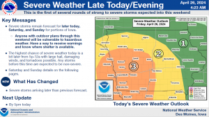
SPOTTER INFORMATION STATEMENT…
Spotter activation may be needed later today, Saturday, and Sunday.
Today: Showers and thunderstorms. Some of the storms could be severe and produce heavy rainfall. High near 69. SE winds 20-40 mph. New rainfall amounts between a quarter and half of an inch possible.
Tonight: Showers and thunderstorms. Some could be severe. Low around 52. S/SW winds @ 15-30 mph. New rainfall amounts between a 1/10 & 1/4 of an inch possible.
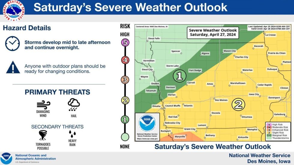
Saturday: Partly sunny w/a 50% chance of showers and thunderstorms, mainly after 1pm. High near 76. S/SW winds 5-10 mph. New rainfall amounts between a tenth and quarter of an inch, except higher amounts possible in thunderstorms.
Sat.Night: Showers and thunderstorms. Low around 57. New rainfall amounts between 1 and 2 inches possible.
Sunday: Showers and thunderstorms. High near 71. New rainfall amounts between a quarter and half of an inch possible.
Sunday Night: A 60% chance of showers and thunderstorms, mainly before 1am. Low around 44.
Monday: Mostly sunny, with a high near 67.
Thursday’s High in Atlantic was 64. Our Low this morning was 49.We received .56″ of rain in Atlantic (From 7-a.m. Thursday up until 7-a.m. today). Last year on this date, the High in Atlantic was 65, and the Low was 36. The All-Time Record High on April 26th in Atlantic, was 92, in 1987 & 1989. The Record Low was 15, in 1907. Sunrise: 6:24. Sunset: 8:12.
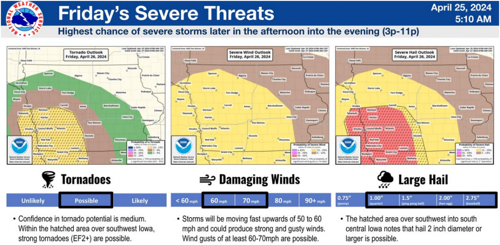
(Radio Iowa) – Whatever your weekend plans, Iowans are being warned they’ll need to keep an eye on the weather, as severe storms may be moving in soon. Meteorologist Andrew Ansorge, at the National Weather Service, says we’ll have scattered rain showers and a few thunderstorms tonight, which shouldn’t pose much trouble, but the rest of the weekend may be a different story. “Friday afternoon, Saturday and Sunday will each feature rounds of strong-to-severe storms,” Ansorge says. “Friday is looking more like mid-to-late afternoon across Iowa, probably southwestern Iowa has the highest risk for seeing tornadoes, large hail and damaging wind gusts. That will move east-northeast across the state into the evening hours.”
If you bought tickets for the Drake Relays, which will conclude in Des Moines this weekend, you’d better bring along a poncho and galoshes. “Saturday, we might get a break in the morning but then looking into Saturday afternoon, storms will redevelop in the afternoon into the overnight hours,” Ansorge says, “and then Sunday, we’ll have to watch to see how things evolve on Saturday into Saturday night, but Sunday also has a risk of severe storms over roughly the southeastern half Iowa.”
We’re in the heart of severe weather season in Iowa, and Ansorge says it’s wise to have a weather radio handy, or a reliable severe weather app on your phone. “Anytime there’s a risk of strong to severe storms, you need to make sure you have multiple ways to receive warnings,” he says, “especially if you’re going to be outside, whether that be for a ballgame, track meet, playing in your garden, make sure you know where your available shelter’s at.”
On April 16th, multiple rounds of severe weather swept across the state, spinning off as many as 13 tornadoes statewide. Some of the twisters were on the ground less than a mile, while a destructive EF2 cut across more than 40 miles of southeast Iowa.
Today: A slight chance of showers, otherwise mostly cloudy & windy, with a high near 66. SE winds 15-30 mph.
Tonight: A chance of showers & thunderstorms. Low around 50. SE winds 20-35 mph.
Friday: Showers and thunderstorms. High near 69. SE winds 20-40 mph.
Fri. Night: Showers and thunderstorms ending late. Low around 53.
Saturday: A 50% chance of showers and thunderstorms in the afternoon, otherwise mostly sunny. High near 78.
Sat. Night: Showers and thunderstorms. Low around 55.
Sunday: Showers and thunderstorms. High near 73.
Wednesday’s High in Atlantic was 68. The Low was 33. Last year on this date, the High in Atlantic was 63, and the Low was 36. The All-Time Record High on April 25th in Atlantic, was 91, in 2012. The Record Low was 20, in 1934. Sunrise: 6:26. Sunset: 8:11.
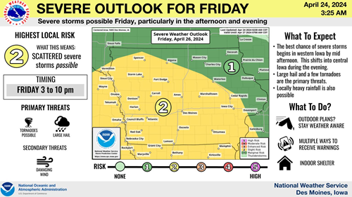
(Des Moines, Iowa) – The National Weather Service’ latest severe weather outlook shows showers and thunderstorms are expected across much of western and central Iowa on Friday into Friday evening along with strong southeast winds. There will be an increasing threat for severe thunderstorms across western Iowa in the afternoon. These storms are expected to move east into the evening spreading the threat of severe weather into central Iowa. Large hail and a few tornadoes are the main threat with these storms along with localized heavy rainfall. Be weather aware throughout Friday and be prepared to seek shelter should a warning be issued for your location!
Today: Areas of frost between 7am and 8am. Otherwise, sunny, with a high near 68. Northeast wind around 10 mph becoming southeast in the afternoon.
Tonight: Mostly cloudy, with a low around 46. SE winds 10-20 mph.
Tomorrow: Mostly cloudy & windy, w/a 40% chance of late afternoon showers & thunderstorms. High near 66. SE @ 15-30 mph.
Tom. Night: Showers and possibly a thunderstorm. Low around 50. SE @ 20-35 mph.
Friday: Showers and possibly a thunderstorm. High near 72.
Fri. Night: Showers and thunderstorms. Low around 53.
Saturday: A chance of afternoon showers & thunderstorms, otherwise Mo. Sunny breezy. High 77.
Tuesday’s High in Atlantic was 69. The Low was 32. Last year on this date, the High in Atlantic was 63, and the Low was 32. The All-Time Record High on April 24th in Atlantic, was 91, in 1989. The Record Low was 9, in 1956. Sunrise: 6:27. Sunset: 8:10.
Early this morning: A chance of showers and thunderstorms. Mostly cloudy, with a steady temperature around 52. Chance of precipitation is 40%. New rainfall amounts of less than a tenth of an inch, except higher amounts possible in thunderstorms.
Today: Mostly cloudy w/a 30% chance of showers before 7am. Gradual clearing, with a high near 68. NW @10-20 w/gusts this afternoon to near 30 mph.New precipitation amounts of less than a tenth of an inch possible.
Tonight: Mostly clear, with a low around 36. Breezy, with a north northwest wind 10-20 mph.
Wednesday: Sunny, with a high near 65. Northeast wind around 10 mph becoming east southeast in the afternoon.
Wed.Night: A 20% chance of showers after 1am. Mostly cloudy, with a low around 45.
Thursday: A chance of showers & thunderstorms after 4pm., otherwise Partly sunny, with a high near 70.
Friday: Showers and possibly a thunderstorm. High near 75. Windy.
Monday’s High in Atlantic was 73. The Low was 41. We received a Trace of rain this morning. Last year on this date, the High in Atlantic was 52, and the Low was 24. The All-Time Record High on April 23rd in Atlantic, was 88, in 1950. The Record Low was 19, in 1893. Sunrise: 6:29. Sunset: 8:09.


