
Today: Mostly cloudy to start-off, then gradually becoming sunny. Breezy. A high near 48. Winds N @ 10-15 gusting to around 25 mph.
Tonight: Mostly clear, with a low around 24.
Tomorrow: Mostly sunny, with a high near 49. Wind becoming S/SW at around 5 mph.
Tom. Night: Cloudy, with a low around 32. S/SE wind 5-10 mph.
Thursday: A 10% chance of rain in the morning, otherwise partly sunny, with a high near 51.
Friday: Mostly sunny, with a high near 51.
Saturday: A 30% chance of rain. A high near 50.
Monday’s High in Atlantic was 70 degrees, which broke the previous record high of 59 set in 1954, 2000 & 2009. The Low was 20. Last year on this date (Feb. 10th), the High in Atlantic was 35, and the Low was 3. The Record High for this date was 72 in 1999, the record Low was -24 in 1905. Sunrise: 7:23; Sunset: 5:46.
Today: Mostly sunny & breezy. A high near 65. S/SW winds 5-15 mph with gusts near around 25 mph.
Tonight: Partly cloudy, with a low around 32. S/SW winds 10-25 mph becoming north after midnight.
Tuesday: Partly sunny, with a high near 49. North wind 10 to 20 mph.
Tue. Night: Partly cloudy, with a low around 27.
Wednesday: Partly sunny, with a high near 47.
Wednesday Night: Mostly cloudy w/a 20% chance of rain after midnight. A low around 30.
Thursday: A 40 percent chance of rain. Mostly cloudy, with a high near 46.
Sunday’s High in Atlantic was 52 degrees. The Low (& 24-hour Low) was 17. Last year on this date (Feb. 9th), the High in Atlantic was 32, and the Low was 1. The Record High for this date was 59 in 1954, 2000 & 2009, & the record Low was -36 in 1975. Sunrise: 7:23; Sunset: 5:46.
Today: Mostly sunny, with a high near 51. Calm wind becoming north around 5 mph.
Tonight: Partly cloudy, with a low around 29. Calm wind becoming south around 5 mph after midnight.
Monday: Mostly sunny, with a high near 64. South wind 5 to 15 mph, with gusts as high as 20 mph.
Tuesday: Mostly cloudy, with a high near 49. North wind 5 to 10 mph.
Wednesday: Partly sunny, with a high near 48.
Thursday: A 30 percent chance of rain. A high near 47.
Saturday’s High in Atlantic was 47 degrees. The Low (& 24-hour Low) was 11. Last year on this date (Feb. 8th), the High in Atlantic was 36, and the Low was 6. The Record High for this date was 62 in 1954 & 2022, & the record Low was -34 in 1971. Sunrise: 7:25; Sunset: 5:45.
Today: Mostly sunny, with a high near 43. Breezy, with an east wind 5 to 10 mph becoming south 11 to 16 mph in the afternoon. Winds could gust as high as 23 mph.
Tonight: Partly cloudy, with a low around 28. South southeast wind 5 to 11 mph becoming west northwest after midnight. Winds could gust as high as 21 mph.
Sunday: Mostly sunny, with a high near 49. North northwest wind 3 to 7 mph.
Sunday Night: Partly cloudy, with a low around 31. Calm wind becoming south southwest around 5 mph after midnight.
Monday: Mostly sunny, with a high near 64. South southwest wind 5 to 13 mph, with gusts as high as 20 mph.
Tuesday: Mostly cloudy, with a high near 50.
Tuesday Night: A 20 percent chance of rain before midnight. Mostly cloudy, with a low around 26.
Friday’s High in Atlantic was 50 degrees. The Low (& 24-hour Low) was 12. Last year on this date (Feb. 7th), the High in Atlantic was 41, and the Low was 21. The Record High for this date was 64 in 1987, & the record Low was -30 in 1905. Sunrise: 7:26; Sunset: 5:43.
(Radio Iowa) – A new map from the U-S Drought Monitor shows almost half of Iowa is considered abnormally dry, while parts of three counties are now in moderate drought. Earlier this week, the state climatologist said Iowa’s in a snow drought, as January snowfall was about six inches below normal.
While months of dry weather triggered a drought resurgence in October, conditions in January improved slightly by comparison, as drought watches and moderate drought designations in eastern Iowa were removed. 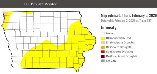 Still, there’s declining soil moisture, and January is typically Iowa’s driest month of the year.
The new drought map shows some 45-percent of the state’s abnormally dry, including much of eastern and southern Iowa along with a small patch in the northwest. That’s also where parts of Lyon, Sioux and Plymouth counties have fallen into moderate drought.
Thursday’s High in Atlantic was 57 degrees. The Low was 29. Last year on this date (Feb. 6th), the High in Atlantic was 41, and the Low was 9. The Record High for this date was 59 in 2009, & the record Low was -27 in 1982. Sunrise: 7:27; Sunset: 5:42.
Today: Mostly cloudy this morning, then gradually becoming sunny. A high near 52. S/SW winds 10-15 becoming NW this afternoon w/gusts to near 20 mph.
Tonight: Mostly clear, with a low around 34. W/NW winds 5-15 mph, with gusts to near 25 mph.
Tomorrow: Sunny & breezy through mid morning, then becoming mostly cloudy. A high near 43. N/NW @ 10-25 mph.
Tom. Night: Mostly clear, with a low around 19.
Saturday: Mostly sunny, with a high near 41.
Saturday Night: Mostly cloudy, with a low around 28.
Sunday: Sunny, with a high near 52.
Sunday Night: Mostly clear, with a low around 32.
Monday: Sunny, with a high near 62.
Wednesday’s High in Atlantic was 34 degrees. The Low was 24. Last year on this date (Feb. 5th), the High in Atlantic was 28, and the Low was 20. The Record High for this date was 66 in 1948, & the record Low was -26 in 1936. Sunrise: 7:28; Sunset: 5:41.
(Radio Iowa) – Iowa’s in the midst of a what’s called a snow drought, according to the state climatologist. While we had three weekends in a row of heavy snows starting right after Thanksgiving, Justin Glisan says there’s been very little statewide snowfall since then. While some Iowans may rejoice at having to do less shoveling, Glisan says it may become a problem once spring arrives — especially for farmers — if there’s little snowmelt and runoff in our rivers. “We’re in a snow drought across the upper Midwest,” Glisan says. “We’ve been running, after a fast start at the end of November and into December, we’re about 2.3 inches statewide average, and that’s about 6 inches below average.”
The new year started out warmer than normal in Iowa, which meant winter storms were dropping more rain than snow. “The interesting thing on the precipitation side is the rainfall event we had early in January,” Glisan says. “We had a wide swath of rainfall — in January — that amounted to, through the state, over nine-tenths of an inch for the monthly average, and that’s about 4/100ths below average.” January was something of a roller-coaster month for temperatures, Glisan says, but we ended up with an average statewide temp of 19-point-3 degrees, just two-tenths of a degree below average. “If you look at the first half of the month, we were running six degrees warmer than average, and then the cold snap through the end of the month dropped that average by about six degrees,” Glisan says, “so here we are, just right around average in terms of temperature.”
Long-range forecasts point to that groundhog being correct, he says, with six more weeks of winter ahead. “If you look at the short-term outlooks for the first half of the month, though, they tell a different story on the temperature side,” Glisan says, “higher probabilities of warmer-than-average temperatures, and we’ll see the temperatures rise through this week and into next week.”
Forecasts call for parts of Iowa to see temps climb into the 50s next week. While the calendar shows winter will last through March 19th, meteorological winter ends February 28th.
Today: Cloudy, with a high near 35. Calm wind becoming N/NW @ 5-10 mph in the morning.
Tonight: Mostly cloudy, with a low around 21. Calm wind becoming S/SW @ 5 to 10 mph after midnight.
Tomorrow: Mostly cloudy, then gradually becoming sunny. A high near 49. S/SW winds in the morning becoming NW in the afternoon, @ 10-20 mph.
Tom. Night: Mostly clear, with a low around 33. W/NW @ 5-15 mph with gusts as high to near 25 mph.
Friday: Sunny & breezy, with a high near 46.
Saturday: Mostly sunny, with a high near 45.
Sunday: Sunny, with a high near 49.
Tuesday’s High in Atlantic was 30 degrees. The Low was 23. Last year on this date (Feb. 4th), the High in Atlantic was 25, and the Low was 8. The Record High for this date was 62 in 1938, & the record Low was -30 in 1905. Sunrise: 7:29; Sunset: 5:40.
Today: Mostly cloudy w/a chance of flurries before 10am. A high near 32. Winds NE this morning @ 5-10 mph becoming calm in the afternoon.
Tonight: Mostly cloudy, with a low around 19.
Tomorrow: Mostly cloudy, with a high near 35. N/NW winds 5-10 mph in the morning.
Tom. Night: Mostly cloudy, with a low around 20.
Thursday: Mostly sunny, with a high near 50.
Thursday Night: Mostly clear, with a low around 32.
Friday: Mostly sunny, with a high near 47.
Monday’s High in Atlantic was 40 degrees. The Low was 18. Last year on this date (Feb. 3rd), the High in Atlantic was 47, and the Low was 8. The Record High for this date was 60 in 1934, & the record Low was -29 in 1996. Sunrise: 7:31; Sunset: 5:38.


