Today: Mostly sunny, with a high near 31. Winds N/NW @ 15-30 mph. Wind chill values as low as 5.
Tonight: Mostly clear, with a low around 17. N/NW winds 10-20 mph.
Tomorrow: Sunny, with a high near 36. N/NW winds 5-10 in the morning becoming S/SW in the afternoon.
Tom. Night: Mostly cloudy, with a low around 23. Winds S @ 5-15 w/gusts to near 25 mph.
Veterans Day (Tuesday): Mostly sunny, with a high near 58.
Tuesday Night: Mostly clear, with a low around 34.
Wednesday: Sunny, with a high near 57.
Saturday’s High in Atlantic was 40. Our Low this morning (as of 5-a.m.) was 21. (We will post 24-hour rainfall at 7-a.m.). Last year on this date (Nov. 9th), the High in Atlantic was 53 & the Low was 45. The Record High for Nov. 9th in Atlantic, was 76 in 2022. The Record Low was 8 in 1973. Sunrise: 7:01; Sunset: 5:06.
Atlantic (@KJAN), .10″
Atlantic (7.1 miles N/NE), .05″
Council Bluffs, .06″
Earling, .10″
Elk Horn, .06″
Imogene, .03″
Logan, .11″
Manning, .07″
Missouri Valley, .11″
Mondamin, .11″
New Market, T (trace of rain)
Persia, .13″
Thurman, .02″
Today: Rain and snow. Little or no snow accumulation expected. High near 37. East wind 5 to 10 mph becoming north northwest in the afternoon.
Tonight: A chance of rain and/or snow flurries until about midnight. Gradually becoming partly cloudy, with a low around 19. Wind chill values as low as 10. Little or no snow accumulation expected.
Sunday: Sunny & breezy, with a high near 32. Winds N/NW @ 15-25 mph. Wind chill values as low as 5.
Sunday Night: Mostly clear, with a low around 16. N/NW winds 5-10 mph, with gusts to near 20 mph.
Monday: Sunny, with a high near 36.
Veterans Day (Tuesday): Mostly sunny, with a high near 58.
Wednesday: Sunny, with a high near 56.
Friday’s High in Atlantic was 65. The Low was 32. We received .10″ of rain overnight through 7-a.m. today. Last year on this date (Nov. 8th), the High in Atlantic was 62 & the Low was 35. The Record High for Nov. 8th in Atlantic, was 80 in 1999 & 2006. The Record Low was -12 in 1991. Sunrise: 7:00; Sunset: 5:07.
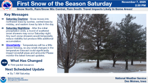
The Des Moines National Weather Service has produced a weather briefing concerning the following hazardous winter weather.
* WHAT – First snowfall of the season.
* WHERE – Most likely in northwestern to north central Iowa, but possible farther south and east as well.
* WHEN – On Saturday, with a few additional snow showers Saturday night.
The briefing is available at https://www.weather.gov/media/dmx/DssPacket.pdf. Additional winter specific information can be found at https://www.weather.gov/dmx/dsswinter
The next email briefing is scheduled to be sent by around 7 AM on Saturday, November 8. 

Today: Sunny & breezy, with a high near 62. W/NW winds 10-20 mph w/gusts to around 25 mph.
Tonight: Cloudy w/a 60% chance of rain and/or snow, mainly after midnight. Low around 36. Little or no snow accumulation expected.
Tomorrow: Rain and snow likely, becoming all rain after 9am. A high near 45. E winds @ 5-10 in the morning becoming N/NW in the afternoon. Little or no snow accumulation expected.
Tom. Night: Blustery, w/a chance of rain and snow before midnight. A low around 20. Winds N @ 10-25 mph. Little or no snow accumulation expected.
Sunday: Sunny & breezy, with a high near 34.
Monday: Sunny, with a high near 39.
Veterans Day (Tuesday): Mostly sunny, with a high near 58.
Thursday’s High in Atlantic was 60. The Low was 37. Last year on this date (Nov. 7th), the High in Atlantic was 57 & the Low was 32. The Record High for Nov. 7th in Atlantic, was 77 in 1915. The Record Low was -14 in 1991. Sunrise: 6:59; Sunset: 5:08.
(Radio Iowa) – Some Iowans could see their first snowflakes of the season this weekend. Meteorologist Dylan Dodson, at the National Weather Service in Johnston, says there are still a lot of uncertainties in the forecast, especially across northern Iowa. “Because the temperature differences at the surface are going to matter a lot,” Dodson says. “One to two degrees could be the difference between rain or snow for you with this system as these typically are towards the beginning of the season.”
While today (Thursday) and Friday should feature unseasonably warm weather, the storm front will move in on Saturday, though the only sure thing is — it’ll be dropping some form of precipitation. “It’s tough to say how much we’re going to get,” Dodson says. “You could see some areas that just get all rain. There could be some areas that look at one to two, maybe even three inches of snowfall. It definitely is going to vary depending on where you’re at and what the temperature is in that area.”
While the forecast calls for parts of the state to experience low temperatures in the teens by Sunday night, highs could be back to near 60 by the middle of next week.
(Radio Iowa) – Forecasters say Iowans should have a few more days of unseasonably warm weather before the cold sets in, so this may be the ideal time to transition the lawn mower to the back of the barn or shed and get the snowblower ready for duty. Kris Kiser, president and C-E-O of the Outdoor Power Equipment Institute, says to prep the mower for storage by sharpening the blade, putting in a new spark plug and air filter, and running it until it runs out of gas. “Fuel has ethanol in it now, which is hygroscopic. It’ll absorb water over time and phase separate. The key is to not let that happen,” Kiser says. “So run the product dry, clean it and try to store it in dry place. That’s key for power equipment.”
If your mower or other tools, like weed trimmers, run on those large, rechargeable batteries, there’s a right way and a wrong way to store those for the winter ahead — and those batteries are pricey, so don’t just leave them attached. “Follow your manufacturer directions to the letter here,” Kiser says. “There are some differences with that, but likely it’s going to be — charge them up, don’t put them on a metal shelf, and store in a cool, dry place.” If your snowblower was put away properly in the spring, he says it should be an easy chore to get it ready for the winter ahead. Fuel stabilizers, products like Sta-bil, may be helpful but Kiser would refer you back to the instruction manual. “The key, I think most engine manufacturers today will say, run it dry, store it dry with nothing else in it,” Kiser says. “It should, when you introduce fresh fuel, remember fuel stales now, and so when you’re ready to bring it back out for the season, use fresh fuel. Don’t have fuel that you’ve kept in a can in the garage for 30 days or more, fresh fuel should bring it back.” 
Does much need to be done to a snowblower to get it ready for action? “A lot of it’s going to be determined by how you put it up, so if you run it dry and you’ve stored it in a dry place, you should likely have no issues whatsoever,” Kiser says. “Not all snow blowers have them, but check the air filter, check the oil, but if you put it up, it’ll likely fire right when you fill it with gasoline. Give it a pull or two, it should fire right away.” Forecasters says light snow is possible in parts of Iowa this weekend, but no accumulation is likely. Still, the flying flakes will be here soon enough, and Kiser says when that day arrives, you’ll want to take another precaution for the health of your snowblower.
“If you’re going to get a snowstorm, clear the area that you intend to plow or blow, because that machine is going to find sticks, debris, the garden hose, dog toys, whatever is left out there. That machine is going to find them, and once the snow covers them, you’re not going to see them,” Kiser says. “So the key is, before the storm, get out there, clear it, you don’t want the machine finding those items.” If you have questions about your power equipment but can’t find the original instruction manual, he notes it’s probably online.
Today: Partly cloudy-to-cloudy. Breezy. A high near 60. Winds South at 10-20 w/gusts to near 30 mph.
Tonight: Cloudy during the early evening, with gradual clearing. A low around 42. Winds diminishing to 5-10 mph.
Tomorrow: Sunny, with a high near 63. Winds West @ 15-25 mph.
Tom. Night: Mostly cloudy, with a low around 35.
Saturday: A 50% chance of rain. A high near 48. N
Saturday Night: Partly cloudy, with a low around 19.
Sunday: Mostly sunny, with a high near 35.
Monday: Sunny, with a high near 40.
Wednesday’s High in Atlantic was 58. The Low was 25. Last year on this date (Nov. 6th), the High in Atlantic was 59 & the Low was 33. The Record High for Nov. 6th in Atlantic, was 77 in 1915. The Record Low was 9 in 1991. Sunrise: 6:58; Sunset: 5:09.
Today: Sunny & breezy, with a high near 57. Winds N @ 15 to 35 mph decreasing during the afternoon.
Tonight: Mostly clear, with a low around 34.
Tomorrow: Increasing clouds, with a high near 60. Breezy, with a south wind 10 to 15 mph, with gusts as high as 30 mph.
Tom. Night: Cloudy, then gradually becoming partly cloudy, with a low around 43.
Friday: Sunny, with a high near 63. West northwest wind 10 to 25 mph.
Friday Night: Partly cloudy, with a low around 35.
Saturday: A 40 percent chance of rain. Mostly cloudy, with a high near 51.
Saturday Night: Partly cloudy, with a low around 20.
Sunday: Sunny, with a high near 35.
Tuesday’s High in Atlantic was 66. The Low was 42. Last year on this date (Nov. 5th), the High in Atlantic was 49 & the Low was 33. The Record High for Nov. 5th in Atlantic, was 79 in 2020. The Record Low was 3 in 1951. Sunrise: 6:56; Sunset: 5:11.
(Radio Iowa) – The final numbers are tallied and state climatologist Justin Glisan says the just-ended month of October ended up being much warmer and drier than usual. “Overall, the temperature was about 57 degrees and that’s about six degrees above average,” Glisan says, “so around the 13th warmest on record with 153 years of records.” As for precipitation, Glisan says rain showers were few and far between during October.
“About 6/10 of an inch below the average,” Glisan says. “There was a swath from southwest through central to north-central Iowa in which we saw above-normal rainfall, and a lot of that rain fell in the last week of October.”
As for the month ahead, he says there are strong signals in the forecast through the first half of November indicating warmer-than-normal temperatures and near-normal precipitation.
********