
TAYLOR IA-CASS IA-ADAIR IA-ADAMS IA-
1212 PM CDT SUN APR 27 2014
…STRONG THUNDERSTORM ENTERING ADAMS COUNTY…
AT 1210 PM CDT…DOPPLER RADAR WAS TRACKING A STRONG THUNDERSTORM
NEAR VILLISCA…OR 11 MILES SOUTHWEST OF CORNING…MOVING NORTHEAST
AT 70 MPH.
NICKEL SIZE HAIL WILL BE POSSIBLE WITH THIS STORM.
THIS STRONG THUNDERSTORM WILL BE NEAR…
CORNING AROUND 1220 PM CDT.
LAKE ICARIA AROUND 1225 PM CDT.
OTHER LOCATIONS IMPACTED BY THIS STORM INCLUDE CUMBERLAND…CARBON…
LAKE ICARIA STATE PARK…BRIDGEWATER…MASSENA…NODAWAY AND CORNING
MUNICIPAL AIRPORT.
PRECAUTIONARY/PREPAREDNESS ACTIONS…
THIS STORM MAY INTENSIFY…SO BE CERTAIN TO MONITOR LOCAL RADIO AND
TV STATIONS…AS WELL AS LOCAL CABLE TV OUTLETS…FOR ADDITIONAL
INFORMATION AND POSSIBLE WARNINGS FROM THE NATIONAL WEATHER SERVICE.
TO REPORT SEVERE WEATHER…CONTACT YOUR NEAREST LAW ENFORCEMENT
AGENCY. THEY WILL RELAY YOUR REPORT TO THE NATIONAL WEATHER SERVICE
OFFICE IN DES MOINES .
1147 AM CDT SUN APR 27 2014
IAZ056-069-079-080-091-271700-
PAGE IA-SHELBY IA-MILLS IA-POTTAWATTAMIE IA-MONTGOMERY IA-
1147 AM CDT SUN APR 27 2014
…SIGNIFICANT WEATHER ADVISORY FOR EAST CENTRAL MILLS…SOUTHEASTERN
SHELBY…PAGE…MONTGOMERY AND SOUTHEASTERN POTTAWATTAMIE COUNTIES
UNTIL 1200 PM CDT…
AT 1147 AM CDT…DOPPLER RADAR WAS TRACKING A LINE OF STRONG
THUNDERSTORMS ALONG A LINE EXTENDING FROM 6 MILES NORTH OF RED OAK TO
7 MILES EAST OF COIN…AND MOVING NORTHEAST AT 50 MPH.
DIME SIZE HAIL AND WINDS IN EXCESS OF 40 MPH WILL BE POSSIBLE WITH
THESE STORMS.
LOCATIONS IMPACTED INCLUDE…
RED OAK…CLARINDA…VILLISCA…ESSEX…STANTON…ELLIOTT…COIN…
COLLEGE SPRINGS…SHAMBAUGH…BRADDYVILLE…GRANT…YORKTOWN…
COBURG…BLANCHARD…HEPBURN AND VIKING LAKE STATE PARK.
THESE STORMS MAY INTENSIFY…SO BE CERTAIN TO MONITOR LOCAL RADIO AND
TV STATIONS…AS WELL AS LOCAL CABLE TV OUTLETS…FOR ADDITIONAL
INFORMATION AND POSSIBLE WARNINGS FROM THE NATIONAL WEATHER SERVICE.
(This post will be updated as information becomes available throughout the day)
11:15-a.m. – Thunderstorm wind gust of 58- mph recorded at the Shenandoah Airport AWOS (Automated Weather Observation System).
1125 AM CDT SUN APR 27 2014
TORNADO WATCH 95 IS IN EFFECT UNTIL 700 PM CDT FOR THE
FOLLOWING LOCATIONS
SOUTHERN IOWA
EASTERN KANSAS
WESTERN AND CENTRAL MISSOURI
* EFFECTIVE THIS SUNDAY MORNING AND EVENING FROM 1125 AM UNTIL 700 PM CDT.
* PRIMARY THREATS INCLUDE…
A FEW TORNADOES AND A COUPLE INTENSE TORNADOES POSSIBLE SCATTERED LARGE HAIL AND ISOLATED VERY LARGE HAIL EVENTS TO 2 INCHES IN DIAMETER POSSIBLE SCATTERED DAMAGING WIND GUSTS TO 70 MPH POSSIBLE.
THE TORNADO WATCH AREA IS APPROXIMATELY ALONG AND 65 STATUTE MILES EAST AND WEST OF A LINE FROM 20 MILES NORTH OF DES MOINES IOWA TO 25 MILES SOUTH OF MONETT MISSOURI.
PRECAUTIONARY/PREPAREDNESS ACTIONS...
REMEMBER…A TORNADO WATCH MEANS CONDITIONS ARE FAVORABLE FOR TORNADOES AND SEVERE THUNDERSTORMS IN AND CLOSE TO THE WATCH AREA. PERSONS IN THESE AREAS SHOULD BE ON THE LOOKOUT FOR THREATENING WEATHER CONDITIONS AND LISTEN FOR LATER STATEMENTS AND POSSIBLE WARNINGS.
IOWA COUNTIES INCLUDED ARE
ADAIR ADAMS APPANOOSE AUDUBON CASS CLARKE DALLAS DECATUR GUTHRIE
JASPER LUCAS MADISON MARION MONROE POLK RINGGOLD TAYLOR UNION
WARREN WAYNE
OMAHA, Neb. (AP) – Rain is falling across southeastern Nebraska and western Iowa, and residents are preparing for the possibility of severe weather later on Sunday. The storms moved into southeast Nebraska Sunday morning and spread into Iowa. The National Weather Service says these storms might produce large hail and damaging winds, so residents are being encouraged to monitor the weather.
A severe thunderstorm warning was issued Sunday morning for the western Iowa counties of Mills, Page, Montgomery and Fremont. That area may see quarter-size hail and 60 mph winds.
The Weather Service says there is a significant chance that more severe storms will develop in Nebraska and Iowa Sunday afternoon.
MILLS IA-PAGE IA-MONTGOMERY IA-FREMONT IA-
1052 AM CDT SUN APR 27 2014
…A SEVERE THUNDERSTORM WARNING REMAINS IN EFFECT UNTIL 1115 AM CDT FOR SOUTHEASTERN MILLS…NORTHWESTERN PAGE…SOUTHWESTERN MONTGOMERY AND EASTERN FREMONT COUNTIES…
AT 1052 AM CDT…SEVERE THUNDERSTORMS WERE LOCATED ALONG A LINE EXTENDING FROM 9 MILES NORTH OF SIDNEY TO NEAR FARRAGUT…MOVING NORTHEAST AT 35 MPH.
HAZARD…60 MPH WIND GUSTS AND QUARTER SIZE HAIL.
SOURCE…RADAR INDICATED.
IMPACT…HAIL DAMAGE TO VEHICLES IS EXPECTED. EXPECT WIND DAMAGE TO
ROOFS…SIDING AND TREES.
LOCATIONS IMPACTED INCLUDE…
MALVERN…SIDNEY…ESSEX…FARRAGUT…EMERSON…RIVERTON…TABOR…
RANDOLPH…HASTINGS…IMOGENE AND PIERCE RECREATION AREA.
THIS INCLUDES THE FOLLOWING HIGHWAYS…
HIGHWAY 34 IN IOWA BETWEEN MILE MARKERS 20 AND 27.
HIGHWAY 59 IN IOWA BETWEEN MILE MARKERS 16 AND 31 .
PRECAUTIONARY/PREPAREDNESS ACTIONS…
FOR YOUR PROTECTION MOVE TO AN INTERIOR ROOM ON THE LOWEST FLOOR OF A
BUILDING.
OMAHA, Neb. (AP) – It looks like Nebraska and Iowa are in for some stormy weather this weekend. The National Weather Service says some Saturday afternoon thunderstorms could be seen in western and central Nebraska, with a chance of severe thunderstorms developing late Saturday night in eastern Nebraska.
On Sunday, there is high chance for thunderstorms statewide, with high winds in parts of eastern Nebraska. In Iowa, sunny skies will turn cloudy by Saturday night, with thunderstorms expected to move into western Iowa by around 9 p.m. Storms will move across the state overnight into Sunday, and could bring heavy rain, hail and high winds. The Des Moines area could see about 2 inches of rain, while parts farther east could up to 2 1/2 inches of rainfall.
The last two southwest Iowa Counties with bans in-place for open burning have been rescinded. The State Fire Marshal’s Office Friday, announced bans which had been in-place since March 19th for Mills and Page Counties were removed today (Friday, April 25th).
And, while there are currently no counties in Iowa under a Burn Ban, area fire officials are asking residents to be very careful when making the decision to conduct controlled burns. Area grass lands and fields are still very dry. Low humidity and forecast strong winds this weekend can cause a controlled burn to quickly become uncontrolled. Care should also be used when using fire pits and grills.
Rain in the forecast for later in the weekend should help to minimize the threat of any explosive fire danger.
909 AM CDT FRI APR 25 2014…CRITICAL FIRE WEATHER CONDITIONS TODAY…
AREA COUNTIES: POTTAWATTAMIE-MILLS-MONTGOMERY-FREMONT-PAGE-
A RED FLAG WARNING IS IN EFFECT UNTIL 8 PM CDT THIS EVENING FOR WIND AND LOW RELATIVE HUMIDITY FOR SOUTHEAST NEBRASKA AND SOUTHWEST IOWA.
* WINDS…SOUTHWEST 15 TO 25 MPH WITH GUSTS UP TO 30 TO 35 MPH.
* RELATIVE HUMIDITY…AS LOW AS 15 TO 25 PERCENT.
* IMPACTS…CONDITIONS WILL BE FAVORABLE FOR FIRES TO START EASILY AND SPREAD QUICKLY. ALL OUTDOOR BURNING SHOULD BE AVOIDED.
PRECAUTIONARY/PREPAREDNESS ACTIONS…
A RED FLAG WARNING MEANS THAT CRITICAL FIRE WEATHER CONDITIONS ARE EITHER OCCURRING NOW…OR WILL SHORTLY. A COMBINATION OF STRONG WINDS…LOW RELATIVE HUMIDITY…AND WARM TEMPERATURES CAN CONTRIBUTE TO EXTREME FIRE BEHAVIOR.
Above normal rainfall was received over the last two weeks in Iowa, with the statewide average was 2.3 inches, as compared to the normal 1.7 inches. However, in its latest Water Summary Report, the Iowa Department of Natural Resources notes more, slow steady rains are needed to bring us out of the drought. The National Drought Monitor indicates improvement in all categories of drought conditions across the state over the past two weeks. Over 35 percent of the state continues to be rated in moderate drought, and just over 5 percent is rated in severe drought. Nearly 60 percent of the state, however, is now shown without drought or just abnormally dry. Those driest areas continue to be two small locations in west-central and southeast Iowa.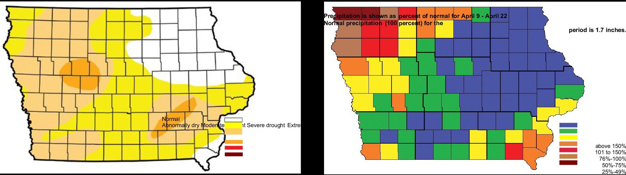
The DNR says that although shallow groundwater levels in southern central, eastern and northeastern Iowa have benefitted from the rainfall, parts of southwest and northwest Iowa received very little rain and shallow groundwater levels are much lower than the previous April. Water supply operators in northwest Iowa are seeing reduced production, dropping water levels and historically low levels.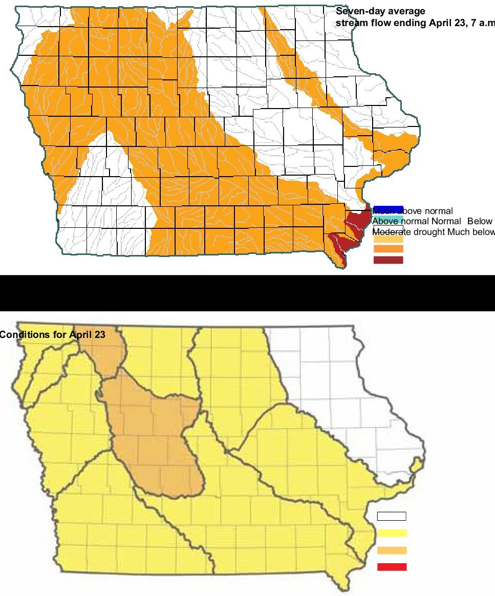
Stream flow has improved statewide, but remains below average. Northeast Iowa remains the wettest, while northwest Iowa is the driest. Groundwater conditions are still low across much of the state, but normal spring rains should continue to bring improvement.
Compared to a year ago, shallow groundwater levels are one to four feet lower in Johnson, Jefferson, Lucas and Montgomery counties, and the same or slightly higher in Marshall, Fayette, Crawford and O’Brien counties.
Compared to two years ago, shallow groundwater levels are 2 to 12 feet lower in Crawford, O’Brien, Jefferson, Johnson, Lucas and Montgomery counties.


