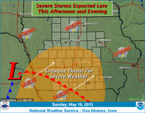
The National Weather Service in Des Moines says scattered thunderstorms will be possible today (Sunday) across central Iowa. However, the thunderstorms will become much more numerous by mid to late afternoon and spread northeast across the state tonight. Large hail, damaging winds and even a few tornadoes are expected with the storms by late afternoon into the evening. Localized heavy rainfall will also be possible, especially in portions of western into northern Iowa late today into tonight.
AREA COUNTIES: SAC-CRAWFORD-CARROLL-AUDUBON-GUTHRIE-DALLAS-CASS-ADAIR-MADISON-ADAMS-UNION-TAYLOR- RINGGOLD
503 AM CDT SUN MAY 19 2013
ISOLATED TO SCATTERED THUNDERSTORMS ARE EXPECTED DURING THE DAY WITH A SEVERE STORM POSSIBLE PRODUCING LARGE HAIL OR A DAMAGING WIND GUST. HOWEVER…MUCH MORE WIDESPREAD THUNDERSTORM ACTIVITY IS EXPECTED TO DEVELOP BY MID TO LATE AFTERNOON AND SPREAD NORTHEAST ACROSS THE AREA INTO TONIGHT.
SIGNIFICANT SEVERE WEATHER IS EXPECTED WITH THESE STORMS LATER THIS AFTERNOON INTO THE EVENING WITH ALL MODES OF SEVERE WEATHER POSSIBLE. GOLF BALL HAIL…DAMAGING SURFACE WINDS IN EXCESS OF 60MPH AND A FEW TORNADOES WILL BE POSSIBLE DURING THIS TIME.
MONDAY AND TUESDAY…SATURDAY SCATTERED THUNDERSTORMS ARE EXPECTED FROM TIME TO TIME ON MONDAY INTO EARLY WEDNESDAY. THERE IS THE THREAT FOR SEVERE WEATHER MONDAY AFTERNOON INTO THE EVENING AS WELL AS AGAIN ON TUESDAY AFTERNOON AND EVENING. MAIN THREAT WILL BE FROM LARGE HAIL AND DAMAGING WINDS ALTHOUGH AN ISOLATED TORNADO CANNOT BE RULED OUT.
SPOTTER INFORMATION STATEMENT… SPOTTER ACTIVATION WILL BE NEEDED LATER THIS AFTERNOON INTO THE EVENING FOR THE OUTLOOK AREA. ADDITIONAL SPOTTER ACTIVATION MAY BE NEEDED FROM TIME TO TIME EARLY IN THE WORK WEEK.
AUDUBON-CARROLL-CRAWFORD-
210 AM CDT SUN MAY 19 2013
…GUSTY WINDS AND SMALL HAIL POSSIBLE…AT 206 AM CDT…NATIONAL WEATHER SERVICE DOPPLER RADAR INDICATED A STRONG THUNDERSTORM 19 MILES SOUTHEAST OF DENISON…MOVING NORTH AT 40 MPH. PEA SIZE HAIL…WINDS UP TO 50 MPH…BRIEF MODERATE DOWNPOURS…ARE POSSIBLE WITH THIS STORM.
LOCATIONS IMPACTED INCLUDE…
MANILLA… GRAY… ASPINWALL…TEMPLETON… MANNING… DENISON…VAIL… HALBUR… DELOIT…WESTSIDE… ARCADIA… KIRON…BREDA…
GUSTY WINDS MAY CAUSE SMALL BRANCHES TO BE BLOWN DOWN…AND LOOSE OBJECTS TO BLOW AROUND. SEEK SHELTER IN A STURDY STRUCTURE UNTIL THIS STORM HAS PASSED.
THE NATIONAL WEATHER SERVICE HAS CANCELLED SEVERE THUNDERSTORM WATCH 175 FOR THE FOLLOWING AREAS
IN IOWA THIS CANCELS 8 COUNTIES: IN SOUTHWEST IOWA – FREMONT HARRISON MILLS MONTGOMERY PAGE POTTAWATTAMIE
SHELBY IN WEST CENTRAL IOWA – MONONA (The Watch was originally set to expire at 4-a.m.)
SHELBY IA-MONTGOMERY IA-POTTAWATTAMIE IA-MILLS IA-PAGE IA-
119 AM CDT SUN MAY 19 2013
…A SEVERE THUNDERSTORM WARNING REMAINS IN EFFECT UNTIL 130 AM CDT FOR SOUTHERN SHELBY…MONTGOMERY…EASTERN POTTAWATTAMIE… NORTHEASTERN MILLS AND NORTHEASTERN PAGE COUNTIES… AT 116 AM CDT…A LINE OF SEVERE THUNDERSTORMS WAS LOCATED ALONG A LINE EXTENDING FROM MACEDONIA TO 6 MILES SOUTH OF CORNING…MOVING NORTHEAST AT 60 MPH.
HAZARD…60 MPH WIND GUSTS. SOURCE…RADAR INDICATED. IMPACT…EXPECT DAMAGE TO ROOFS…SIDING AND TREES. LOCATIONS IMPACTED INCLUDE… RED OAK…CLARINDA…OAKLAND…VILLISCA…WALNUT…STANTON…CARSON… EMERSON…ELLIOTT…MACEDONIA…HASTINGS…HENDERSON…
GRANT…HEPBURN AND COBURG. PRECAUTIONARY/PREPAREDNESS ACTIONS… FOR YOUR PROTECTION MOVE TO AN INTERIOR ROOM ON THE LOWEST FLOOR OF A BUILDING.
120 AM CDT SUN MAY 19 2013
...A SEVERE THUNDERSTORM WARNING REMAINS IN EFFECT FOR ADAMS AND TAYLOR COUNTIES UNTIL 130 AM CDT…
AT 117 AM CDT…A LINE OF SEVERE THUNDERSTORMS WAS LOCATED ALONG A LINE EXTENDING FROM 7 MILES NORTH OF VILLISCA TO 11 MILES SOUTH OF CORNING TO 6 MILES SOUTHEAST OF BEDFORD…AND MOVING NORTHEAST AT 65 MPH.
NATIONAL WEATHER SERVICE OMAHA/VALLEY NE
115 AM CDT SUN MAY 19 2013
SEVERE THUNDERSTORM WATCH 175 REMAINS VALID UNTIL 4 AM CDT EARLY THIS MORNING FOR THE FOLLOWING AREAS
IN IOWA THIS WATCH INCLUDES 8 COUNTIES IN SOUTHWEST IOWA: FREMONT HARRISON MILLS MONTGOMERY PAGE POTTAWATTAMIE SHELBY; IN WEST CENTRAL IOWA: MONONA
107 AM CDT SUN MAY 19 2013

THE NATIONAL WEATHER SERVICE IN DES MOINES HAS ISSUED A

* SEVERE THUNDERSTORM WARNING FOR...
  ADAMS COUNTY IN SOUTHWEST IOWA...
  TAYLOR COUNTY IN SOUTHWEST IOWA...

* UNTIL 130 AM CDT

* AT 103 AM CDT...A LINE OF SEVERE THUNDERSTORMS WAS LOCATED ALONG A
  LINE EXTENDING FROM 7 MILES NORTHEAST OF ESSEX TO CLARINDA TO
  HOPKINS...AND MOVING NORTHEAST AT 60 MPH.

  HAZARD...60 MPH WIND GUSTS.

  SOURCE...RADAR INDICATED.

  IMPACT...EXPECT DAMAGE TO ROOFS...SIDING AND TREES.

* LOCATIONS IMPACTED INCLUDE...
  BEDFORD...CORNING...LENOX...ATHELSTAN...NODAWAY...GRAVITY...
  BLOCKTON...CONWAY...CARBON...SHARPSBURG...CLEARFIELD AND PRESCOTT.

PRECAUTIONARY/PREPAREDNESS ACTIONS...

FOR YOUR PROTECTION MOVE TO AN INTERIOR ROOM ON THE LOWEST FLOOR OF A
BUILDING.
103 AM CDT SUN MAY 19 2013

THE NATIONAL WEATHER SERVICE IN OMAHA HAS ISSUED A

* SEVERE THUNDERSTORM WARNING FOR...
  NORTHEASTERN FREMONT COUNTY IN SOUTHWEST IOWA...
  EASTERN MILLS COUNTY IN SOUTHWEST IOWA...
  MONTGOMERY COUNTY IN SOUTHWEST IOWA...
  PAGE COUNTY IN SOUTHWEST IOWA...
  EASTERN POTTAWATTAMIE COUNTY IN SOUTHWEST IOWA...
  SOUTHERN SHELBY COUNTY IN SOUTHWEST IOWA...

* UNTIL 130 AM CDT

* AT 1258 AM CDT...A LINE OF SEVERE THUNDERSTORMS WAS LOCATED ALONG A
  LINE EXTENDING FROM MALVERN TO CLARINDA...MOVING NORTHEAST AT 60
  MPH.

HAZARD...60 MPH WIND GUSTS.

SOURCE...RADAR INDICATED.

IMPACT...EXPECT DAMAGE TO ROOFS...SIDING AND TREES.

* LOCATIONS IMPACTED INCLUDE...
  RED OAK...CLARINDA...SHENANDOAH...OAKLAND...VILLISCA...MALVERN...
  ESSEX...WALNUT...STANTON...CARSON...FARRAGUT...EMERSON...ELLIOTT...
  MACEDONIA...COIN...TABOR...COLLEGE SPRINGS...THURMAN...HASTINGS AND
  RANDOLPH.

PRECAUTIONARY/PREPAREDNESS ACTIONS...

FOR YOUR PROTECTION MOVE TO AN INTERIOR ROOM ON THE LOWEST FLOOR OF A
BUILDING.
925 PM CDT SAT MAY 18 2013
SEVERE THUNDERSTORM WATCH 175 IS IN EFFECT UNTIL 400 AM CDT FOR THE FOLLOWING COUNTIES IN IOWA: FREMONT HARRISON LYON MILLS MONONA MONTGOMERY PAGE PLYMOUTH POTTAWATTAMIE SHELBY SIOUX WOODBURY.
SCATTERED THUNDERSTORMS ARE EXPECTED TONIGHT…AND SEVERE STORMS ARE POSSIBLE. LARGE HAIL AND DAMAGING WINDS ALONG WITH LOCALLY HEAVY RAIN WILL BE THE PRIMARY HAZARDS.
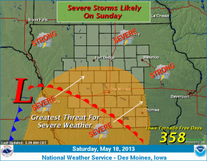
Partial sunshine is expected today with temperature mainly in the 80s across Iowa. Scattered thunderstorms are expected to push into the state late tonight with periods of thunderstorms on Sunday into Sunday night. Severe weather appears likely on Sunday afternoon into Sunday evening with the threat of large hail…damaging winds and even a few tornadoes.