
Today: Sunny & windy, with a high near 62. N/NW winds 10-20 this morning gusting to near 35 mph this afternoon. There is an elevated fire danger risk due to strong winds and low humidity.
Tonight: FROST ADVISORY in effect after midnight. Mostly clear, with a low around 33. N/NW wind 5 to 15 mph, with gusts to around 20 mph.
Columbus Day: FROST ADVISORY until 9-a.m. Widespread frost, mainly between 8am and 9am. Otherwise, mostly sunny, with a high near 58. N/NW winds 5 to 10 mph in the morning.
Monday Night: Mostly cloudy, with a low around 33.
Tuesday: Widespread frost, mainly before 8am. Otherwise, sunny, with a high near 55.
Tuesday Night: Widespread frost, mainly after 11pm. Otherwise, mostly clear, with a low around 26.
Wednesday: Widespread frost before 9am. Otherwise, sunny, with a high near 60.
Saturday’s High in Atlantic was 77. The Low was 42. Last year on this date, the High in Atlantic was 62, and the Low was 48. The Record High was 88 in 1975. The Record Low was 15 in 1907. Sunrise: 7:29; Sunset: 6:42.
Today: Mostly sunny, with a high near 78. Northeast wind 5 to 10 mph.
Tonight: Mostly clear, with a low around 46. Northwest wind 5 to 10 mph.
Sunday: Sunny & windy, with a high near 63. N/NW winds 15-30 mph.
Sun. Night: Mostly clear w/frost possible after midnight. Low 33.
Columbus Day: Widespread frost in the morning. Sunny. High near 59. N/NW winds 5 mph in the afternoon.
Monday Night: Widespread frost. Partly cloudy, with a low around 32.
Tuesday: Widespread frost, mainly before 8am. Otherwise, sunny, with a high near 57.
Friday’s High in Atlantic was 87. Our Low was 53. Last year on this date, the High in Atlantic was 62, and the Low was 52. The Record High on Oct. 12th, was 90 in 1899. The Record Low was 17 in 1908. Sunrise: 7:28; Sunset: 6:44.
(Radio Iowa) – After last month turned out to be Iowa’s driest September on record, October’s shaping up to be just as dry and the drought conditions are worsening. The new map from the U.S. Drought Monitor shows the patches of severe drought are growing in both western Iowa and in the northeast, now covering more than seven percent of the state. A much larger section, 49-percent, is considered in moderate drought, and that stretches across the majority of Iowa’s northern half and much of the west. About 41-percent of the state is considered abnormally dry, while only about two-and-a-half percent has no moisture worries — at the moment at least — across a few counties in the southwest.
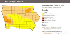
Graphic from the U.S. Drought Monitor
Forecasters say a cold front should start to arrive tonight (Friday) that will bring progressively colder temperatures over the next several days, with the first frost likely for Iowa next Tuesday. There are little to no chances for rain for at least another week.
Today: Mostly sunny, with a high near 86. South wind 5 to 10 mph becoming west in the afternoon.
Tonight: Mostly cloudy, with a low around 52. Northeast wind 10-20 mph.
Tomorrow: Mostly sunny, with a high near 78. East northeast wind around 5 mph.
Tom. Night: Mostly clear, with a low around 46. North wind 5 to 7 mph.
Sunday: Sunny, with a high near 64. Breezy.
Sunday Night: Areas of frost after 5am. Otherwise, partly cloudy, with a low around 34.
Columbus Day: Areas of frost before 8am. Otherwise, sunny, with a high near 58.
Tuesday: Widespread frost before 9am. Otherwise, sunny, with a high near 59.
Thursday’s High in Atlantic was 87. Our Low was 40. Last year on this date, the High in Atlantic was 69, and the Low was 52. The Record High on Oct. 11th, was 93 in 1893. The Record Low was 17 in 1987. Sunrise: 7:27; Sunset: 6:45.
(Midwest) – The Aurora Borealis (Northern Lights) put on quite a show Thursday night into early this (Friday) morning, across the northern hemisphere, including much of Iowa. Social media posts showed pictures of the phenomenon from all over. The Northern Lights are caused by what the Space Weather Prediction Center says was a geomagnetic storm that strengthened to a G4. Normally, the waves of colorful light are seen over the far northern regions of Alaska and parts of the world closer to the north pole.
Here are just a few of the images seen across social media, and those sent to KJAN by area residents:

Carroll County (Courtesy Chris Pecbot)

Carroll County (Courtesy Chris Pecbot)

Carroll County (Courtesy Chris Pecbot)
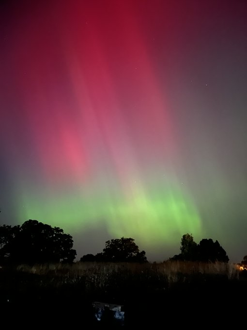
Image from the National Weather Service (Des Moines)
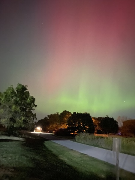
Image from the National Weather Service (Des Moines)

Glenwood Fire Dept. Facebook post

From our sister station KDSN in Denison
(Radio Iowa) – Forecasters say the summer-like weather will have a last hurrah today (Thursday) and tomorrow before we fall headlong into the more seasonable chill of autumn, with a frost and freeze likely early next week. Meteorologist Craig Cogil at the National Weather Service, says Iowans are in for a temperature rollercoaster over the next few days. “We’re going to see highs in the upper 70s to 80s across much of the state as we head into Friday, even near-record highs are expected across portions of central and southern Iowa,” Cogil says, “so certainly unseasonably warm weather as we end out the work week.” Just last weekend, many Iowa communities saw high temps in the mid-90s. This weekend, though, it’ll definitely feel like fall as a cold front is expected to arrive late Friday.
“We’re going to see progressively colder air move into the state through the weekend. It looks like the coldest morning will be Tuesday morning, with lows down in the mid to upper 20s in northern Iowa, to lower 30s in southern Iowa,” Cogil says. “So it does look like widespread frost and freeze conditions across the state and probably the end of the growing season.” Iowa’s first frost is tracking right on target, Cogil says, as next Tuesday is the 15th of October. “In general, a good average is right around the 15th of the month,” Cogil says. “You go up into northern Iowa, it’s usually the first week. If you get down into southeast, south-central Iowa, it’s usually the third or last week of the month. So yeah, it’s about average.”
Cogil says the weather pattern that produced both hurricanes Helene and Milton in the Gulf of Mexico is having a continued impact on Iowa’s climate, too. “One of the biggest effects we’ve seen from that is the fact that it’s keeping a lot of the moisture that might work up into the central part of the United States, it’s keeping it down in the Gulf,” Cogil says. “We’re not really seeing much moisture return, which is leading to a lot of the -at least- dry conditions that we’ve seen recently.”
A new map is due out later this (Thursday) morning from the U-S Drought Monitor. The map from last week shows only about six Iowa counties have no significant moisture problems, while around 70-percent of the state is abnormally dry, with 23-percent of Iowa in moderate drought, and portions of Harrison and Monona counties in western Iowa under severe drought.
Today: Mostly sunny. High near 83. S/SW winds 5-10 becoming mostly southerly.
Tonight: Mostly clear, with a low around 56. South southeast wind 5 to 10 mph.
Tomorrow: Mostly sunny. High near 85. South winds 5 to 10 mph becoming westerly in the afternoon.
Tom. Night: Mostly cloudy, with a low around 50. Northeast wind 5 to 10 mph.
Saturday: Mostly sunny, with a high near 76.
Sunday: Sunny & breezy. High near 64.
Sun. Night: Mostly clear w/areas of frost after midnight. Low around 35.
Columbus Day: Areas of frost in the morning. Mostly sunny. High near 58.
Wednesday’s High in Atlantic was 83 (4 degrees shy of the record high). The Low was 38. Last year on this date, the High in Atlantic was 70 and the Low was 29. The Record High in Atlantic on Oct. 10th was 96 in 1893. The Record Low was 17 in 1906. Sunrise: 7:26. Sunset: 6:47.
Today: Mostly sunny, with a high near 81. South southwest wind 5 to 10 mph.
Tonight: Partly cloudy, with a low around 49. Light south southeast wind.
Tomorrow: Mostly sunny, with a high near 84. Light south southeast wind becoming south 5 to 10 mph in the morning.
Thursday Night: Mostly clear, with a low around 56.
Friday: Mostly sunny, with a high near 85.
Friday Night: Partly cloudy, with a low around 50.
Saturday: Mostly sunny, with a high near 76.
Saturday Night: Mostly clear, with a low around 44.
Sunday: Sunny & breezy, with a high near 61.
Tuesday’s High in Atlantic was 78. The Low was 34. Last year on this date, the High in Atlantic was 64 and the Low was 29. The Record High in Atlantic on Oct. 9th was 87 in 1930, 1938 & 2020. The Record Low was 14 in 2000. Sunrise: 7:25. Sunset: 6:49.
Today: Sunny, with a high near 78. Winds S/SW @ 5 to 10 mph.
Tonight: Mostly clear, with a low around 46. South wind around 5 mph.
Tomorrow: Sunny, with a high near 82. S/SW wind 5 to 10 mph.
Thursday: Sunny, with a high near 84.
Friday: Mostly sunny, with a high near 85.
Friday Night: Partly cloudy, with a low around 51.
Monday’s High in Atlantic was 73. The Low was 30. Last year on this date, the High in Atlantic was 73 and the Low was 34. The Record High in Atlantic on Oct. 8th was 93 in 1893. The Record Low was 19 in 1908 & 2000. Sunrise: 7:24. Sunset: 6:50.
(Des Moines, Iowa) – More than half of Iowa soybeans and nearly a quarter of the state’s corn have been harvested as of Monday’s crop report. The warm and dry weather from September persisted into October and led to increased drought and burn bans across the state. The Iowa Capital Dispatch says the crop report shows Iowa farmers harvested 31% of the state’s soybeans acreage during the reporting period of Sept. 30 through Oct. 6, bringing the total acres harvested to 58%. Harvest percentages for corn harvested for grain doubled from last week, with 22% of the crop harvested and 90% reaching maturity.
The state climatologist report for the same period said the Iowa saw a high temperature of 96 degrees Fahrenheit (reported in Atlantic) and a statewide average rainfall of 0.10 inches, or 0.64 inches below normal. The majority of topsoil and subsoil moisture rated short or very short, and a persistent decline in pasture conditions gave producers concern about water for livestock.
A small portion of west central Iowa moved from moderate drought to severe drought conditions over the span of a week, and more than 90% of the state remains in abnormally dry or worse conditions, according to the U.S. Drought Monitor. These conditions increased the likelihood of fires, especially on combines and other field equipment as it gets hot. The crop progress and condition report for the week said several combine and equipment fires were reported.
State Fire Marshal Dan Wood said he didn’t have a report of the number of equipment fires from the past week, but said 46 Iowa counties are in a burn ban. He urged Iowans, and farmers, to be cautious around things that could start a fire. “Make sure that farmers are trying to keep their combines and tractors cleaned off of debris and stuff, especially the parts that get hot,” Wood said.
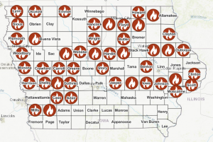
Iowa has 46 active burn bans, represented by a flame icon on the map, as of Monday. (Map courtesy of Iowa State Fire Marshal)
He said folks should take care to properly dispose of cigarettes during these dry, windy conditions, and call in anything they see smoking on the side of the road.


