
The Shelby County Emergency Management Agency says the grassland/field fire danger level will remain “HIGH” through this weekend. Continued drying conditions, make the potential for grassland and standing corn fires higher than normal. Caution should be observed when burning and, notices provided to your local Fire Chief . 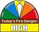
The next local update will be Monday October 19th.
Early This Morning: Clear…colder. Areas of frost. North wind near 10 mph.
Today: Frost Advisory until 9-a.m.; Sunny…cooler. Areas of frost through mid morning. High in the mid 50s. Northwest wind 5 to 10 mph.
Tonight: Partly cloudy. Patchy frost early in the morning. Low in the mid 30s. North wind near 5 mph shifting to the southeast after midnight.
Saturday: Frost Advisory from 1-a.m. until 9-a.m.; Mostly sunny. Patchy frost through mid morning. High in the upper 50s. Southeast wind near 10 mph shifting to the south in the afternoon.
Saturday Night: Mostly clear. Low in the upper 30s. Southeast wind 5 to 10 mph.
Sunday: Sunny…breezy. High in the upper 60s. South wind 5 to 15 mph increasing to 15 to 20 mph in the afternoon.
Sunday Night: Partly cloudy. Warmer. Low around 50.
Monday: Mostly sunny. Breezy. High in the mid 70s.
(Issued 3:54-a.m.) COUNTIES affected: SAC-CRAWFORD-CARROLL-AUDUBON-CASS-ADAMS-TAYLOR–HARRISON-SHELBY-POTTAWATTAMIE-MILLS-MONTGOMERY-FREMONT-PAGE.
A FROST ADVISORY REMAINS IN EFFECT UNTIL 9 AM CDT THIS MORNING.
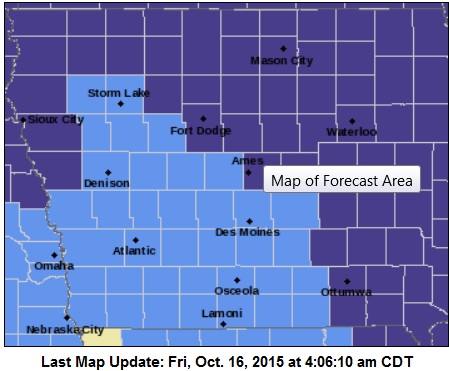
Frost Advisory for counties in light blue; Freeze Warning for counties shown in purple.
A FROST ADVISORY WILL BE IN EFFECT FROM 1 AM TO 9 AM CDT SATURDAY, FOR:SAC-CRAWFORD-CARROLL-AUDUBON-CASS-ADAMS-TAYLOR GUTHRIE-DALLAS-ADAIR-MADISON- UNION AND RINGGOLD COUNTIES.
TEMPERATURE READINGS MAY DIP INTO THE 30S EARLY THIS MORNING AND THE LOWER 30S EARLY SATURDAY MORNING. AREAS OF FROST ARE EXPECTED TO FORM EARLY THIS MORNING AND AGAIN EARLY SATURDAY MORNING. THESE CONDITIONS WILL LIKELY DAMAGE OR KILL SENSITIVE VEGETATION THAT HAS BEEN LEFT UNPROTECTED.
Today: Clear to P/Cldy & breezy. High near 70. W/NW @ 10-20 w/gusts to near 30.
Tonight: Areas of frost after 4am. Mo. Clear. Low around 32. N/NW 5-10. .
Friday: **Frost Advisory 3-am to 9-am**Areas of frost before 8-am, otherwise Sunny. High near 58. N/NW @ 5-10.
Fri. Night: Partly cloudy. Low around 34.
Saturday: P/Cldy. High near 61. S/SE wind 5 to 15 mph.
Saturday Night: Mostly clear, with a low around 39.
Sunday: P/Cldy & breezy. High near 68.
WEATHER DATA: Wednesday’s High in Atlantic was 72. Our 24-hour Low ending at 7-a.m. today was 37. Last year on this date, our High was 69 and the Low was 33.
The All-time Record High in Atlantic on Oct. 15th was 89 in 1892. The All-Time record low was 17 in 1952. Sunrise today is at 7:31, and sunset tonight will take place at 6:39.
Today: Mostly sunny. Breezy. High in the upper 60s. West wind 5 to 10 mph increasing to north 15 to 20 mph with gusts to around 30 mph in the afternoon.
Tonight: Clear. Areas of frost early in the morning. Low in the mid 30s. Northwest wind 5 to 10 mph. Gusts up to 20 mph through midnight.
Friday: **FROST ADVISORY beginning at 3-a.m.**Sunny…cooler. Areas of frost through mid morning. High in the mid 50s. Northwest wind 5 to 10 mph.
Friday Night: Partly cloudy. Low in the mid 30s. North wind near 5 mph shifting to the east after midnight.
Saturday: Mostly sunny. High in the upper 50s. Southeast wind 5 to 15 mph.
Saturday Night: Mostly clear. Low in the upper 30s.
Sunday: Mostly sunny. Breezy. High in the mid 60s.
Special Weather statement for the following KJAN listening area counties: SAC-CRAWFORD-CARROLL-AUDUBON-GUTHRIE-DALLAS-CASS-ADAIR-MADISON-ADAMS-UNION-TAYLOR-RINGGOLD
338 AM CDT THU OCT 15 2015
…STRONG WINDS AND DRY CONDITIONS LEAD TO HIGH FIRE DANGER…
NORTHWEST WINDS WILL INCREASE SUBSTANTIALLY TODAY BECOMING VERY GUSTY BY THE AFTERNOON. RELATIVE HUMIDITY WILL ALSO FALL TO VERY LOW VALUES IN THE 20S THIS AFTERNOON. AS A RESULT, CONDITIONS
WILL BE HAZARDOUS FOR BURNING OR ANY FIRES THAT START AS THEY MAY BE ABLE TO SPREAD QUICKLY…ESPECIALLY IN FIELDS OR AREAS WHERE SURFACE VEGETATION HAS CURED.
ANY BURNING IS STRONGLY DISCOURAGED, AND THOSE ENGAGING IN HARVESTING ACTIVITIES SHOULD BE AWARE OF THE INCREASED FIRE THREAT.
401 AM CDT THU OCT 15 2015
FROST EXPECTED OVER WESTERN IOWA TONIGHT. A COLD FRONT IS EXPECTED TO PUSH THROUGH IOWA LATER TODAY ALLOWING TEMPERATURES TO DROP INTO THE 30S FOR OVERNIGHT LOWS. HIGH PRESSURE WILL SETTLE BEHIND INTO THE HIGH PLAINS WITH CLEAR SKIES AND LIGHT WINDS ALLOWING FOR FAVORABLE CONDITIONS FOR FROST DEVELOPMENT…ESPECIALLY IN THE NISHNABOTA VALLEY.
CASS-ADAMS-AUDUBON-CARROLL-CRAWFORD-FREMONT-HARRISON-MILLS-MONTGOMERY-PAGE-SHELBY-TAYLOR COUNTIES…
FROST ADVISORY IN EFFECT FROM 3 AM TO 9 AM CDT FRIDAY.
* TEMPERATURE…OVERNIGHT LOWS ARE EXPECTED TO DIP INTO THE MIDDLE 30’S.
* IMPACTS…AREAS OF FROST ARE EXPECTED TO FORM DURING THE EARLY MORNING HOURS FRIDAY…LIKELY IMPACTING SENSITIVE VEGETATION THAT HAS BEEN LEFT UNPROTECTED.
PRECAUTIONARY/PREPAREDNESS ACTIONS…
A FROST ADVISORY MEANS THAT FROST IS POSSIBLE. SENSITIVE OUTDOOR PLANTS MAY BE KILLED IF LEFT UNCOVERED OR NOT BROUGHT INDOORS.
The latest U-S-D-A crop report shows the harvest is 12 days ahead of last year for corn and 10 days ahead for soybeans, but one section of the state is lagging well behind those numbers. Iowa State University agronomist Aaron Saeugling monitors 12-southwest Iowa counties. “In southwest Iowa it’s going to be a long fall,” Saeugling says.
That’s because constant rains, some often several inches, delayed planting and kept some fields from being planted. That makes for a lot of different scenarios in the fields. ”I’ve got producers who are wrapping up soybeans and I’ve got producers that haven’t started,” according to Saeugling.
It’s not all of southwest Iowa — not even all of some farms. “So for those guys it’s kind of bittersweet,” Saeugling says, “they’ve got fields that are yielding better than they ever dreamed of. They’ve got fields they won’t harvest.” Either way, the area is well behind the statewide average for corn of 20 percent harvested and 65 percent for soybeans. “If I had to average — probably pushing really close to fifty-percent on beans. Corn right now, maybe twenty percent,” Saeugling estimates.
In contrast, in northwest Iowa where things were drier, an agronomist reports two-thirds of the corn and nearly all of the soybeans are already harvested.
(Radio Iowa)
Today: Partly Cloudy. High Around 70. NW wind @ 10mph.
Tonight: P/Cldy. Low 40. Winds light & variable.
Tomorrow: P/Cldy to Cldy w/isolated shwrs possible. High 70. S-N @ 10-15.
Tom. Night: Mo. Clear. Low around 35.
Friday: Mostly Sunny. High around 59.
Friday night: P/Cldy w/areas of frost after midnight. Low around 32.
Saturday: P/Cldy. High 61.
Tuesday’s High in Atlantic was 75. Our 24-hour Low ending at 7-a.m. today was 37.
Last year on this date, our High was 65 and the Low was 33.
The All-time Record High in Atlantic on Oct. 14th was 88 in 1897. The All-Time record low was 16 in 1937. Sunrise today is at 7:30, and sunset tonight will take place at 6:41.
Early This Morning: Clear. Northwest wind 5 to 15 mph with gusts to around 25 mph.
Today: Sunny. High in the lower 70s. Northwest wind around 5 mph.
Tonight: Partly cloudy. Low in the mid 40s. Southwest wind around 5 mph.
Thursday: Mostly sunny. High in the upper 60s. West wind near 10 mph shifting to the north with gusts to around 25 mph in the afternoon.
Thursday Night: Mostly clear. Colder. Low in the mid 30s. North wind 5 to 10 mph.
Friday: Sunny…cooler. High in the mid 50s. North wind 5 to 10 mph.
Friday Night: Partly cloudy. Areas of frost after midnight. Low in the lower 30s.
Saturday: Sunny. High in the upper 50s.


