
With recent rain and the forecast for showers or light rain in the immediate forecast, the Shelby County Emergency Management Agency is asking local fire departments and businesses in the county who possess “Fire Danger” signs, to place those signs in the “High” category, through the weekend. That’s downgraded from Monday’s “Extreme” rating. Officials say another factor in the decision to lower the danger index, is the number of fields left to harvest, has dwindled.
The next update on fire danger conditions will be posted Monday morning.
Today: Isolated sprinkles thru 9-am; A chance of light rain this afternoon, otherwise Cloudy, with a high near 63. East northeast wind 5 to 15 mph.
Tonight: Cloudy w/a 70% chance of showers and possibly a thunderstorm, especially after midnight. Low around 57. E/SE wind 10 to 15mph, with gusts as high as 20.
Friday: An 80% chance of showers & thunderstorms. High near 68. SE @ 15-25.
Friday Night: Mostly cloudy w/a 30% chance of showers through midnight. Low around 48. S/SW winds 10-15mph becoming W/NW after midnight.
Saturday: Mostly sunny, with a high near 64.
Sunday: Sunny, with a high near 68.
Wednesday’s High in Atlantic was 69. Our 24-hour Low ending at 7-a.m. today was 50. We received .10” (one-tenth of an inch) of rain the past 24-hours (.09 yesterday morning, .01 this morning). Last year on this date, our High was 70 and the Low was 50. The All-time Record High in Atlantic on Oct. 22nd was 87 in 1899. The All-Time record low was 15 in 1976. Sunrise today is at 7:40, and sunset tonight will take place at 6:29.
EARLY THIS MORNING: MOSTLY CLOUDY. ISOLATED SPRINKLES. NORTHEAST WIND AROUND 5 MPH.
TODAY: CLOUDY. ISOLATED SPRINKLES THROUGH MID MORNING. HIGH IN THE MID 60S. EAST WIND 5 TO 15 MPH.
TONIGHT: CLOUDY. A CHANCE OF SHOWERS THROUGH MIDNIGHT. ISOLATED THUNDERSTORMS THROUGH THE NIGHT. SHOWERS LIKELY AFTER MIDNIGHT. LOW IN THE MID 50S. SOUTHEAST WIND 10 TO 15 MPH. CHANCE OF PRECIPITATION 70 PERCENT.
FRIDAY: SHOWERS AND ISOLATED THUNDERSTORMS UNTIL LATE AFTERNOON, THEN SHOWERS LIKELY AND ISOLATED THUNDERSTORMS LATE IN THE AFTERNOON. HIGH IN THE UPPER 60S. SOUTH WIND 10 TO 15 MPH WITH GUSTS TO AROUND 25 MPH. CHANCE OF PRECIPITATION 80 PERCENT.
FRIDAY NIGHT: MOSTLY CLOUDY WITH A 30 PERCENT CHANCE OF SHOWERS THROUGH MIDNIGHT…THEN PARTLY CLOUDY AFTER MIDNIGHT. LOW IN THE UPPER 40S. SOUTHWEST WIND 10 TO 15 MPH SHIFTING TO THE WEST AFTER MIDNIGHT.
SATURDAY: MOSTLY SUNNY. HIGH IN THE LOWER 60S. NORTHWEST WIND 10 TO 15 MPH.
SUNDAY: MOSTLY SUNNY. HIGH IN THE LOWER 60S.
Today: Partly Cloudy to Cloudy w/isolated showers & thunderstorms. High near 70. NW winds @ 10-15mph.
Tonight: P/Cldy. Low 45. N @ 5.
Tomorrow: P/Cldy to Cldy. High 68. SE @ 10.
Tom. Night: Cldy w/a 60% chance of shwrs. Low 55.
Friday: Mostly cloudy w/scattered shwrs & tstrms. High near 68. .
Fri. Night:. Mo. Cldy w/a 30% chance of shwrs. Low 49.
Saturday: P/Cldy. High near 66.
Tuesday’s High in Atlantic was 77. Our 24-hour Low ending at 7-a.m. today was 55. Last year on this date, our High was 72 and the Low was 32. The All-time Record High in Atlantic on Oct. 21st was 87 in 1947. The All-Time record low was 13 in 1930. Sunrise today is at 7:38, and sunset tonight will take place at 6:30.
346 AM CDT WED OCT 21 2015
EARLY THIS MORNING…MOSTLY CLOUDY. SOUTH WIND NEAR 10 MPH.
TODAY…MOSTLY CLOUDY. A SLIGHT CHANCE OF SHOWERS AND ISOLATED THUNDERSTORMS THROUGH MID MORNING…THEN ISOLATED THUNDERSTORMS BEFORE NOON. HIGH IN THE LOWER 70S. NORTHWEST WIND 5 TO 10 MPH. CHANCE OF PRECIPITATION 20 PERCENT.
TONIGHT…MOSTLY CLOUDY. COOLER. LOW IN THE UPPER 40S. NORTHEAST WIND 5 TO 10 MPH.
THURSDAY…MOSTLY CLOUDY. HIGH IN THE UPPER 60S. EAST WIND 5 TO 15 MPH.
THURSDAY NIGHT…CLOUDY. A CHANCE OF SHOWERS THROUGH MIDNIGHT, THEN SHOWERS LIKELY AFTER MIDNIGHT. LOW IN THE MID 50S. SOUTHEAST WIND 10 TO 15 MPH. CHANCE OF SHOWERS 60 PERCENT.
FRIDAY…SHOWERS. HIGH IN THE MID 60S. SOUTHEAST WIND 10 TO 15 MPH WITH GUSTS TO AROUND 25 MPH. CHANCE OF SHOWERS 80 PERCENT.
FRIDAY NIGHT…MOSTLY CLOUDY. A CHANCE OF SHOWERS THROUGH MIDNIGHT…THEN A SLIGHT CHANCE OF SHOWERS AFTER MIDNIGHT. LOW AROUND 50. CHANCE OF SHOWERS 30 PERCENT.
SATURDAY…MOSTLY SUNNY. HIGH IN THE LOWER 60S.
Today: Partly Cloudy to Cloudy w/scattered showers & thunderstorms possible. High around 75. S winds @ 10-20mph.
Tonight: P/Cldy to Cldy w/scatt. Shwrs. Low 58. S @ 5-10.
Wednesday: P/Cldy to Cldy w/isolated morning shwrs. High 68. N @ 10-15.
Wed. Night: Mostly cloudy. Low around 47.
Thursday: Mostly cloudy, with a high near 68. East wind 5 to 10 mph.
Thu. Night: A 40 percent chance of showers. Low around 55.
Friday: A 70% chance of shwrs. High near 70.
Monday’s High in Atlantic was 80. Our 24-hour Low ending at 7-a.m. today was 57. Last year on this date, our High was 72 and the Low was 32. The All-time Record High in Atlantic on Oct. 20th was 87 in 1947 & 2003. The All-Time record low was 14 in 1960. Sunrise today is at 7:38, and sunset tonight will take place at 6:32.
Early This Morning: Mostly cloudy. South wind 10 to 15 mph.
Today: Partly sunny. High in the mid 70s. South wind 5 to 15 mph with gusts to around 25 mph.
Tonight: Partly cloudy until early morning then becoming mostly cloudy. Low in the upper 50s. South wind 5 to 10 mph.
Wednesday: Partly sunny. High in the lower 70s. West wind 5 to 10 mph shifting to the northwest 5 to 15 mph in the afternoon.
Wednesday Night: Mostly cloudy. Cooler. Low in the upper 40s. Northeast wind 5 to 10 mph.
Thursday: Mostly cloudy with a 20 percent chance of showers. High in the upper 60s. East wind 5 to 15 mph.
Friday: Showers likely. High in the mid 60s. Chance of showers 70 percent.
A Red Flag Warning is posted statewide today (Monday), for all but a few counties in northwest Iowa. The National Weather Service says the risk of wildfires is high due to strong winds, low humidity and dry vegetation. Farmers need to be especially cautious as they harvest dry crops. Iowa State University Extension ag engineer Kris Kohl says a recent survey found strong winds are the most common cause of combine fires.
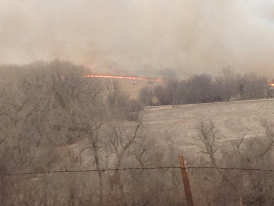
File photo (area field fire March 2014)
“Wind is the number-one factor, especially when you’re above 25 miles an hour, to having fires,” Kohl says. “If we are harvesting, be very careful about bearings and stuff sitting on it because if we get a fire going, it’ll really take off.” He says farmers might be wise to give their equipment frequent breaks to cool off and for clean up.
“Stop every two or three hours and take a leaf blower and blow all of the chaff off of things,” Kohl says. “Check bearings to make sure nothing is getting hot. Bearings and exhaust are the two things that are prevalent when we have fires from combines.”
Two years ago, there were two major combine fires in northwest Iowa, which prompted the survey. Last week’s windy conditions contributed to several large fires in North and South Dakota. Forecasters say there’s a chance for some showers in Iowa tomorrow (Tuesday) though some areas of the state haven’t had significant moisture in several weeks.
(Radio Iowa)
The Shelby County Emergency Management Agency is asking local fire departments and businesses in the county who possess “Fire Danger” signs, to place those signs in the “Extreme” category. High wind, low humidity, and significant crop left in the field will make for extreme fire danger this week. Any fires that start will be difficult to control and could spread rapidly. No burning is allowed during this period.
 The next update will be Thursday Morning.
Today: **RED FLAG WARNING**Partly cloudy, windy & warm. High near 82. South/southwest wind 15-30mph, with gusts to near 40.
Tonight: Partly cloudy, with a low around 60. South wind 10-15 w/gusts to 25.
Tuesday: P/Cldy w/a slight chance of showers & thunderstorms through 1-pm. High near 75. South wind 10-15 w/gusts to around 20. New rainfall amounts of less than a tenth of an inch, except higher amounts possible in thunderstorms.
Tue. Night: P/Cldy w/a slight chance of showers and thunderstorms after midnight. Low around 57. .
Wednesday: P/Cldy to Cldy. High near 70. W/SW wind @ 5-10mph becoming N/NW during the afternoon.
Thursday: Partly sunny, with a high near 70.
**********
Sunday’s High in Atlantic was 69. Our 24-hour Low ending at 7-a.m. today was 43.
Last year on this date, our High was 69, and the Low was 35.
The All-time Record High in Atlantic on Oct. 19th was 88 in 2003. The All-Time record low was 12 in 1972. Sunrise today is at 7:36, and sunset tonight will take place at 6:33.


