
Today: Sunny, with a high near 40. S/SW winds 10-20 mph. Wind chill values as low as 5.
Tonight: Mostly clear, with a low around 23.
Tomorrow: Sunny, with a high near 53. SW winds 10-20 mph.
Tom. Night: Mostly clear, with a low around 31. SW winds 10-20 mph.
Sunday: Sunny, with a high near 55.
Sunday Night: Partly cloudy, with a low around 31.
Monday: Mostly sunny & breezy, with a high near 46.
Tuesday: Partly sunny, with a high near 34.
Thursday’s High in Atlantic was 23. Our Low was 7. Last year on this date, the High in Atlantic was 53 & the Low was 29. The Record High here on Dec. 6th, was 69 in 1939, and the Record Low was -12 in 2005. Sunrise: 7:31. Sunset: 4:50.
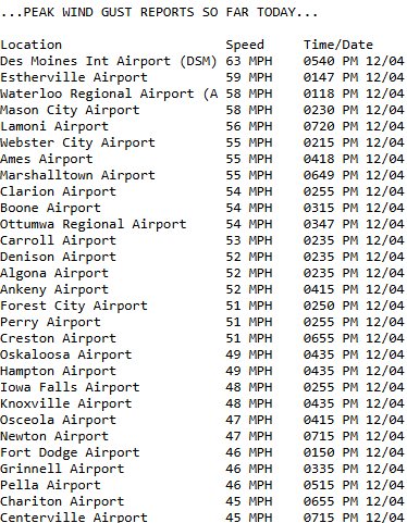
(Des Moines, Iowa) – The National Weather Service, Wednesday evening, posted a list of peak wind gusts Iowa experienced while the State was under a Wind Advisory. Preliminary data from airport weather data sites show the highest gust of 63 mph was recorded at the Des Moines International Airport, at 5:40-p.m. 17 sites recorded gusts anywhere from 50- to 59 mph. The Atlantic airport recorded a peak wind gust of 44 mph at 3:35-p.m. There were no immediate reports of damage caused by the high winds.
Top wind gusts Dec. 4, 2024 (courtesy the NWS):
Today: Sunny & blustery. High near 23. N/NW winds 10-25 mph w/wind chill values as low as -10.
Tonight: Partly cloudy, with a low around 12. S/SW winds around 5 mph. Wind chill values as low as 5.
Friday: Sunny, with a high near 39. SW winds 5-15 w/gusts to near 20. Wind chill values as low as 5.
Friday Night: Mostly clear, with a low around 21.
Saturday: Sunny, with a high near 49.
Saturday Night: Mostly clear, with a low around 34.
Sunday: Mostly sunny, with a high near 54.
Sunday Night: Mostly cloudy, with a low around 31.
Monday: Mostly sunny, with a high near 43.
Wednesday’s High in Atlantic was 47. Our Low this morning was 7. Last year on this date, the High in Atlantic was 41 & the Low was 13. The Record High here on Dec. 5th, was 66 in 2021, and the Record Low was -14 in 2005. Sunrise: 7:30. Sunset: 4:50.
Today: Mostly sunny & windy. High near 40. NW winds @ 10-20 mph this morning gusting to near 40 this afternoon. **WIND ADVISORY IN EFFECT FROM 11-A.M. UNTIL MIDNIGHT**
Tonight: Mostly clear & windy. Low around 7. N/NW winds 20-40 mph decreasing after midnight. Wind chill values as low as -5.
Tomorrow: Sunny. High near 22. N/NW winds 15-25 mph. Wind chill values as low as -5.
Friday: Sunny, with a high near 38.
Saturday: Sunny, with a high near 49.
Sunday: Mostly sunny, with a high near 53.
Tuesday’s High in Atlantic was 36. The Low was 15. Last year on this date, the High in Atlantic was 39 & the Low was 26. The Record High here on Dec. 4th, was 66 in 1998, & the Record Low was -8, in 1905. Sunrise: 7:29. Sunset: 4:50.
Today: Sunny & breezy, with a high near 35. Wind chill values as low as 5. S/SW winds 10-20 mph w/gusts to around 25.
Tonight: Mostly clear, with a low around 25. S/SW winds 10-20.
Wednesday: Mostly sunny & windy, with a high near 39. NW winds @ 15-35 mph.
Wed. Night: Mostly clear & windy, with a low around 6. NW @ 15-35 mph.
Thursday: Sunny, with a high near 22.
Friday: Sunny, with a high near 38.
Saturday: Sunny, with a high near 47.
Monday’s High in Atlantic was 26. The Low was 10. Last year on this date, the High in Atlantic was 39 & the Low was 22. The Record High here on Dec. 3rd, was 64 in 2017, & the Record Low was -13, in 1919.
(Radio Iowa) – State Climatologist Justin Glisan says this fall is going down among the warmest we’ve ever seen in Iowa. “Over four degrees above average for meteorological fall, September, October, November, so with 152 years of records looking like in the top 10 warmest falls on record,” Glisan says. The fall was on course to be one of the driest on record through the first two months.
“The driest September, on record, 51st driest October, and then we get into a wet November. So kind of a balancing act there, but overall, we were drier than average, and that’s where we did see some drought conditions reemerge across the state. Recently we’ve had improvements with a wetter November,” he says. He says rains late in November kept it from a dry overall outcome.
“Not too much snow. We had a few flakes flying through the month, some rainfall, though we were about three inches, three and a quarter inches across the state, and that’s almost an inch-and-a-half above average,” Glisan says. Glisan says November was wet enough to push it up the record chart. “Overall for November, this looks like it will be in the top 20 wettest November is on record,” he says.
November also saw temperatures about three degrees above average.
Today: Cloudy, then gradually becoming mostly sunny, with a steady temperature around 21. Winds North @ 10-20 mph. Wind chill values as low as 5.
Tonight: Mostly cloudy, then gradually becoming mostly clear, with a low around 11.
Tomorrow: Sunny & breezy, with a high near 34. S/SW winds 10-25 mph. Wind chill values as low as zero.
Tom. Night: Mostly clear, with a low around 24.
Wednesday: Mostly sunny & windy, with a high near 43.
Wed. Night: Mostly clear, with a low around 8. Windy.
Thursday: Mostly sunny, with a high near 22.
Sunday’s High in Atlantic was 30. Our Low was 12. We had received slightly more than .2″ of snow overnight at KJAN. Last year on this date, the High in Atlantic was 37 & the Low was 28. The Record High here on Dec. 2nd, was 65 in 2021, & the Record Low was -10, in 1985.
(Atlantic, Iowa – KJAN) – Weather data for the month of November, 2024, in Atlantic, shows we were warmer and wetter than normal. The average High for the month was 51-degrees, thanks to six days that were in the 60’s. The normal (average high is 46). The average Low for November was 29, which was just two-degrees warmer than normal. Rainfall for the month amounted to 3.91 inches, which was a little more than two-inches above the norm (1.85″). There was a dusting of snow the last couple of days of the month. The data was compiled at KJAN, the official National Weather Service reporting site for Atlantic.
Looking ahead, we find the High temperature for the month of December in Atlantic, is 33 degrees, while the average Low is 14. Precipitation typically amounts to 1.1 inches.
Check back with us during the first week of January, 2025, to see how our actual weather data compared to the historical averages.
Today: A chance of flurries between 3pm and 4pm, then a chance of snow after 4pm. Mostly cloudy, with a high near 28. Wind chill values as low as 5. North northwest wind around 5 mph becoming calm in the afternoon. Chance of precipitation is 30%. Total daytime snow accumulation of less than a half inch possible.
Tonight: Snow likely before 3am, then a chance of flurries between 3am and 4am. Cloudy, with a low around 14. Wind chill values as low as 5. Light north wind becoming north northwest 5 to 10 mph after midnight. Winds could gust as high as 20 mph. Chance of precipitation is 60%. New snow accumulation of less than one inch possible.
Monday: Mostly sunny, with a high near 24. Wind chill values as low as zero. North northwest wind 10-20 mph.
Monday Night: Partly cloudy, with a low around 8.
Tuesday: Sunny, with a high near 35. S/SW winds 10-25 mph.
Tuesday Night: Mostly clear, with a low around 24.
Wednesday: Sunny, with a high near 44.
Saturday’s High in Atlantic was 26. Our Low this morning was 11. We had a dusting (Trace) of snow last night. Last year on this date, the High was 39 and the Low was 20. The All-time Record High for Dec. 1st in Atlantic, was 67 in 1998. The Record Low was -10 in 1892. Sunrise today: 7:26. Sunset: 4:51.
Today: Mostly cloudy w/a slight chance of flurries or light snow. High near 28. North winds 5-10. Wind chill values as low as 5.
Tonight: A chance of flurries, otherwise mostly cloudy, with a low around 10. Wind chill values as low as 5.
Tomorrow: Mostly sunny, with a high near 27. NW winds 5-10. Wind chill values as low as zero.
Tom. Night: A chance of flurries before midnight, otherwise mostly cloudy, with a low around 11.
Monday: Mostly sunny, with a high near 26.
Tuesday: Mostly sunny, with a high near 36.
Wednesday: Sunny, with a high near 44.
Friday’s High in Atlantic was 34. The Low was 10. Last year on this date, the High was 49and the Low was 25. The All-time Record High for Nov. 30th in Atlantic, was 66 in 1922. The Record Low was -10 in 1964. Sunrise today: 7:25. Sunset: 4:51.


