
401 AM CST THU DEC 31 2015
EARLY THIS MORNING…MOSTLY CLEAR. COLDER. WEST WIND AROUND 5 MPH.
TODAY…MOSTLY SUNNY. HIGH IN THE LOWER 20S. WEST WIND 5 TO 10 MPH.
TONIGHT…PARTLY CLOUDY. LOW AROUND 10. WEST WIND 5 TO 10 MPH.
NEW YEARS DAY…SUNNY. HIGH IN THE UPPER 20S. WEST WIND 10 TO 15 MPH.
SATURDAY…SUNNY. HIGH IN THE LOWER 30S. WEST WIND 5 TO 10 MPH.
SUNDAY…SUNNY. HIGH IN THE UPPER 20S.
Today: Mostly Cloudy w/snow likely before 10-am, then scattered flurries. 1” or less accumulation is expected. High near 25. W/NW @ 10-20.
Tonight: Gradually becoming partly cloudy. Low around 10. W/NW @ 5-10. Wind chill values as low as zero.
Tomorrow: Partly cloudy. High around 21. W/SW @ 10-15.
New Year’s Eve: Partly cloudy, with a low around 9. W/NEW @ 5-10.
New Year’s Day: Clear to P/Cldy. High near 25.
Friday Night: Clear, with a low around 13.
Saturday: P/Cldy. High near 30.
Tuesday’s High in Atlantic was 24. Our 24-hour ending at 7-a.m. today, was 12. We received .3” of snow overnight and until 7-a.m. That amounted to just .04” precipitation.
Last year on this date we reached 11 for a High and -4 was the low. The All-time Record High in Atlantic on this date was 64 in 2004, while the Record Low was -22 in 1917.
The National Weather Service says a fast moving weather system will produce periods of light snow this morning. Snowfall amounts will range from a dusting to around one inch. The morning commute will likely be impacted with roads become snow covered and slippery. Just before 6-a.m., the Iowa Dept. of Transportation’s map at 511ia.org showed most roads in southwest Iowa between Highway 92 and Highway 44, were partially covered with snow. South of Highway 92, roads were mostly covered with snow. The snowfall should move east of the area by around noon.
Otherwise expect mostly cloudy conditions the remainder of the afternoon with highs in the 20s. Mostly cloudy and cold conditions are expected on Thursday although it should be dry. Quiet but cold conditions are expected on New Year’s Eve with lows in the single digits north to the lower teens south. Expect some sunshine on New Year’s Day with seasonal temperatures in the 20s.
Early This Morning: Light snow. Little or no new snow accumulation. West wind near 5 mph. Chance of snow 80 percent.
Today: Cloudy. Light snow likely through mid morning…then scattered flurries before noon. Little or no snow accumulation. High in the mid 20s. West wind 5 to 10 mph. Chance of snow 70 percent.
Tonight: Mostly cloudy. Low 5 to 10 above. West wind 5 to 10 mph.
Thursday: Mostly sunny. High in the lower 20s. West wind 5 to 10 mph.
Thursday Night: Partly cloudy. Low 5 to 10 above. West wind 5 to 10 mph.
New Years Day: Sunny. High in the mid 20s. West wind 10 to 15 mph.
Friday Night: Mostly clear. Low 10 to 15.
Saturday: Sunny. High in the upper 20s.
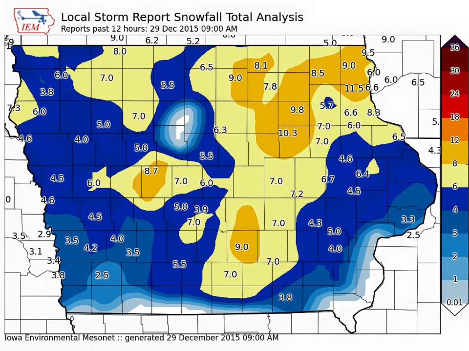
The National Weather Service today (Tuesday) released a graphic on their Facebook page showing the latest report on snowfall totals from Monday. The report was compiled as of 9-a.m. today. Some areas in north central Iowa remain blank because there were insufficient reports to the NWS to complete the image (Click on the graphic below to enlarge)…
Today: Mostly Cloudy, with flurries. High near 22. NW @ 10-20. Wind chill values as low as 5.
Tonight: Mo. Cldy w/a 40% chance of snow, mainly between midnight and 5am. Low around 13. N-NW @ 10-15. New snow accumulation of less than a half inch possible.
Wednesday: Cloudy w/a 20% chance of snow before noon. High near 24. W/NW @ 10-15.Wind chill values as low as 10.
Wednesday Night: Cloudy to P/Cldy. Low around 7. Wind chill values as low as zero.
Thursday: Partly Cloudy. High near 20. West wind 5 to 10 mph.
Thursday Night: Partly cloudy, with a low around 7.
New Year’s Day: P/Cldy. High near 22.
Monday’s High in Atlantic was 23. Our 24-hour ending at 7-a.m. today, was 17. We received 3.8-inches of snow yesterday, for a storm total of 4-inches at KJAN. The 3.8 inches of snow melted into just .16” of liquid precipitation. Last year on this date we reached 23 for a High and -1 was the low. The All-time Record High in Atlantic on this date was 60 in 1984, while the Record Low was -22 in 1917.
EARLY THIS MORNING…CLOUDY. NORTHWEST WIND AROUND 10 MPH.
TODAY…CLOUDY. HIGH IN THE LOWER 20S. NORTHWEST WIND 5 TO 10 MPH.
TONIGHT…CLOUDY. LOW AROUND 15. NORTHWEST WIND NEAR 5 MPH.
WEDNESDAY…CLOUDY. HIGH IN THE LOWER 20S. WEST WIND 5 TO 10 MPH.
WEDNESDAY NIGHT…MOSTLY CLOUDY. LOW 5 TO 10 ABOVE. WEST WIND 5 TO 10 MPH.
THURSDAY…PARTLY SUNNY. HIGH 15 TO 20. WEST WIND 5 TO 10 MPH.
THURSDAY NIGHT…MOSTLY CLOUDY. LOW 5 TO 10 ABOVE.
NEW YEARS DAY…MOSTLY SUNNY. HIGH IN THE LOWER 20S
In its mid-morning update, the National Weather Service says a major winter storm remains on track to impact much of Iowa today and tonight. The storm track has shifted a bit east, though, and as a result the greatest expected snowfall amounts have also shifted east a bit. In western and southwest Iowa, the Weather Service predicts anywhere from 4-to 7-inches is possible, with Guthrie County and points north and slightly northwest receiving 6- to 10-inches of snow.
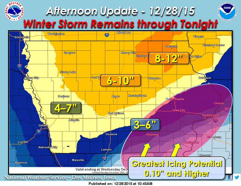 As much as 12″ of snow or more is possible across northeast Iowa, while much of northern and portions of central Iowa may see 6-10″ of snow through tonight. The combination of strong winds and heavy snow (snowfall rates of 1″ per hour at times) is expected to cause blowing snow over central and northwest Iowa. A wintry mix of freezing rain, sleet and snow remains in the forecast for southeast Iowa. With the potential for significant icing over areas such as Ottumwa and northeast towards the Quad Cities, where as much as a half inch or more of ice is possible. Damage to power lines and trees will be possible as well, especially with additional force from expected high winds.
Travel conditions will continue to be treacherous at times, especially as another round of moderate to heavy precipitation is expected to arrive by mid-afternoon. Do not travel unless absolutely necessary today. Click here for the latest briefing and forecast information: http://www.weather.gov/dmx/dssforecast
**Winter Storm Warning in effect**
Today: Snow/blowing snow, possibly mixed at times w/freezing rain. High 28. N @ 15-30. (6-10” possible in the Atlantic area).
Tonight: Snow tapering off to flurries by midnight. Low 15. N @ 20-35.
Tomorrow: P/Cldy to Cldy. High around 20. N @ 10-20.
Wednesday: Mo. Cldy w/flurries. High 22.
Thursday: P/Cldy. High 20.
Sunday’s High in Atlantic was 23. Our 24-hour ending at 7-a.m. today, was 11. We received .2” of snow early this morning (as of 7-a.m.). Last year on this date we reached 34 for a High and 15 was the low. The All-time Record High in Atlantic on this date was 65 in 1893 & 1984, while the Record Low was -25 in 1924.
**Winter Storm Warning in effect now until Midnight**
Early This Morning: Cloudy with a 50 percent chance of light snow. Breezy. Northeast wind 15 to 25 mph with gusts to around 35 mph.
Today: Snow. Areas of blowing snow. Windy. Snow may be heavy at times in the morning. Snow accumulation around 7 inches. High in the upper 20s. Northeast wind 20 to 30 mph with gusts to around 45 mph. Chance of snow near 100 percent.
Tonight: Cloudy…breezy. Light snow in the evening…then light snow likely before midnight. A chance of light snow after midnight. Snow accumulation around 1 inch. Low around 20. North wind 15 to 20 mph. Gusts up to 35 mph through midnight. Chance of snow 90 percent.
Tuesday: Mostly cloudy. High in the mid 20s. West wind 5 to 15 mph.
Tuesday Night: Cloudy. A 20 percent chance of light snow after midnight. Low around 15. West wind 5 to 10 mph.
Wednesday: Mostly cloudy. A 20 percent chance of light snow in the morning. High in the lower 20s. West wind 5 to 10 mph.
Wednesday Night: Mostly cloudy. Low 5 to 10 above.
Thursday: Partly sunny. High around 15.


