
Early This Morning: Cloudy. South wind around 5 mph.
Today: Cloudy. High in the mid 20s. South wind 5 to 10 mph.
Tonight: Cloudy. Low 15 to 20. Southeast wind 5 to 10 mph.
Thursday: Cloudy. High in the upper 20s. Northeast wind around 10 mph.
Thursday Night: Cloudy. A 20 percent chance of snow after midnight. Low around 15. North wind around 10 mph.
Friday: Mostly cloudy in the morning then becoming mostly sunny. High in the mid 20s. North wind 10 to 15 mph.
Friday Night: Partly cloudy. Low 5 to 10 above.
Saturday: Partly sunny. High in the upper 20s.
**Winter Weather Advisory for snow, in effect until 6-p.m.**
Today: Snow. (1-3” total in the Atlantic area is expected) High near 19. E/SE @ 5-10. Wind chill values as low as zero.
Tonight: Snow ending before 8pm. Cloudy, to P/Cldy. Low around 9. Little or no snow accumulation expected.
Wednesday: P/Cldy to Cldy. High near 25. S @ 5-10. Wind chill values as low as 5. Wed. Night: Cloudy, with a low around 19.
Thursday: Cldy w/a slight chance of morning snow or flurries. High near 30.
Friday: P/Cldy. High near 22.
We received a dusting of snow early this morning (from 5-to 7-am), which amounted to just a trace of precipitation. Monday’s High in Atlantic was 15. The 24-hour Low ending at 7-a.m. today was -3. Last year on this date we reached 48 for a High and 22 was the low. The All-time Record High in Atlantic on this date was 56 in 1895, while the Record Low was -38 in 1892.
…WINTER WEATHER ADVISORY IN EFFECT UNTIL 6 PM CST THIS EVENING…
EARLY THIS MORNING…CLOUDY WITH A 50 PERCENT CHANCE OF LIGHT SNOW. NOT AS COLD. SOUTHEAST WIND 5 TO 10 MPH.
TODAY…LIGHT SNOW. SNOW ACCUMULATION OF 2 TO 3 INCHES. HIGH 15 TO 20. SOUTHEAST WIND AROUND 10 MPH. CHANCE OF SNOW 90 PERCENT.
TONIGHT…CLOUDY. A 50 PERCENT CHANCE OF SNOW IN THE EVENING. LOW 10 TO 15. SOUTHEAST WIND 5 TO 10 MPH.
WEDNESDAY…PARTLY SUNNY. HIGH IN THE UPPER 20S. SOUTH WIND 5 TO 10 MPH.
THURSDAY…CLOUDY. A 20 PERCENT CHANCE OF LIGHT SNOW IN THE MORNING. HIGH AROUND 30. EAST WIND 5 TO 10 MPH SHIFTING TO THE NORTH IN THE AFTERNOON.
FRIDAY…MOSTLY CLOUDY. HIGH IN THE LOWER 20S.
328 AM CST TUE JAN 19 2016
MODERATE SNOWFALL EXPECTED OVER SOUTHERN AND SOUTHWESTERN IOWA TODAY. SNOW WILL SPREAD FROM WEST TO EAST THIS MORNING AND PERSIST INTO TONIGHT…RESULTING IN MODERATE ACCUMULATIONS LIKELY ACROSS SOUTHWESTERN AND SOUTHERN IOWA. LIGHT ACCUMULATIONS ARE EXPECTED ELSEWHERE.
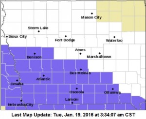 CRAWFORD-CARROLL-AUDUBON-GUTHRIE-CASS-ADAIR-ADAMS-UNION-TAYLOR-RINGGOLD-MONONA-HARRISON-SHELBY- POTTAWATTAMIE-MILLS-MONTGOMERY-FREMONT- PAGE–COUNTIES: A WINTER WEATHER ADVISORY REMAINS IN EFFECT UNTIL 6 PM CST THIS EVENING.
SNOW WILL BEGIN DURING THE EARLY MORNING HOURS AND END IN THE LATE AFTERNOON. STORM TOTAL SNOW ACCUMULATIONS…2 TO 4 INCHES WITH THE HIGHEST AMOUNTS TOWARD THE MISSOURI BORDER. WINDS WILL BE SOUTHEAST AT AROUND 10 MPH. VISIBILITY DURING TIMES OF HEAVIEST SNOWFALL WILL FALL TO A MILE OR LESS. ROADS WILL BECOME SLICK AND SNOW PACKED AND WILL CREATE HAZARDOUS TRAVEL CONDITIONS AT TIMES.
DALLAS-AND MADISON COUNTIES: A WINTER WEATHER ADVISORY REMAINS IN EFFECT FROM NOON TODAY TO 9 PM CST THIS EVENING. AGAIN, 2-4″ OF SNOW IS POSSIBLE.
PRECAUTIONARY/PREPAREDNESS ACTIONS…
A WINTER WEATHER ADVISORY FOR SNOW MEANS THAT PERIODS OF SNOW WILL CAUSE PRIMARILY TRAVEL DIFFICULTIES. BE PREPARED FOR SNOW COVERED ROADS AND LIMITED VISIBILITIES…AND USE CAUTION WHILE DRIVING.
MONONA-HARRISON-SHELBY-POTTAWATTAMIE-MILLS-MONTGOMERY-FREMONT-PAGE COUNTIES….347 PM CST MON JAN 18 2016
THE NATIONAL WEATHER SERVICE IN OMAHA/VALLEY HAS ISSUED A WINTER WEATHER ADVISORY FOR SNOW…WHICH IS IN EFFECT FROM 4 AM TO 6 PM CST TUESDAY.
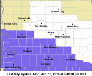
Winter Weather Advisory for counties shaded in purple
CRAWFORD-CARROLL-AUDUBON-GUTHRIE-CASS-ADAIR-ADAMS-UNION-TAYLOR- RINGGOLD COUNTIES...WINTER WEATHER ADVISORY IN EFFECT FROM 6 AM TO 6 PM CST TUESDAY.
LIGHT SNOW WILL BEGIN TO FALL OVER THE FAR SOUTHWEST LATE TONIGHT AND CONTINUE TO SPREAD EAST THROUGH TUESDAY. MODERATE ACCUMULATIONS ARE EXPECTED TO BEGIN DURING THE MORNING HOURS TUESDAY. THE SNOW WILL END FROM WEST TO EAST TUESDAY EVENING.
TOTAL SNOW ACCUMULATIONS…2 TO 4 INCHES WITH HIGHEST AMOUNTS SOUTH OF INTERSTATE 80.
* LOOK FOR REDUCED VISIBILITIES AT TIMES. PLAN ON SLIPPERY ROAD CONDITIONS…INCLUDING DURING THE MORNING COMMUTE ON TUESDAY.
PRECAUTIONARY/PREPAREDNESS ACTIONS…
A WINTER WEATHER ADVISORY FOR SNOW MEANS PERIODS OF SNOW WILL CAUSE PRIMARILY TRAVEL DIFFICULTIES. BE PREPARED FOR SNOW COVERED ROADS AND LIMITED VISIBILITIES…AND USE CAUTION WHILE DRIVING.
**Wind Chill Advisory until 9-a.m.**
Today: Clear to P/Cldy. High near 12. W @ 5-10. Wind chill values as low as -15.
Tonight: P/Cldy to Cldy w/a 30% chance of snow. Low around 3 w/temps slowly rising overnight. SE @ 5-10. Wind chill values as low as -5. New snow accumulation of less than a half inch possible.
Tuesday: Cloudy w/snow. High near 18. E/SE @ 10-15. Wind chill values as low as -5.
Tuesday Night: Snow, mainly before 7pm. Low around 10. New snow accumulation of less than one inch possible. (total snow accumulation of 1-3” possible).
Wednesday: Partly sunny, with a high near 25.
Wednesday Night: Cloudy w/a slight chance of snow. Low around 17.
Thursday: Cloudy w/a slight chance of snow. High near 25.
Sunday’s High in Atlantic was 3. The 24-hour Low ending at 7-a.m. today was -8. Last year on this date we reached 55 for a High and 18 was the low. The All-time Record High in Atlantic on this date was 61 in 1951, while the Record Low was -28 in 1984.
CASS-ADAIR-MADISON-ADAMS-UNION-TAYLOR-RINGGOLD-CRAWFORD-CARROLL- AUDUBON-GUTHRIE-DALLAS COUNTIES:
A WIND CHILL ADVISORY REMAINS IN EFFECT UNTIL 9 AM CST THIS MORNING.
* WINDS…NORTHWEST AT 5 TO 12 MPH.
* TEMPERATURES/WIND CHILL VALUES…AIR TEMPERATURES WILL REMAIN IN THE SINGLE DIGITS BELOW ZERO THIS MORNING WITH WIND CHILLS OF 15 TO 25 BELOW ZERO.
* IMPACTS…FROSTBITE CAN OCCUR TO EXPOSED SKIN WITHIN 30
MINUTES OR LESS.
PRECAUTIONARY/PREPAREDNESS ACTIONS…
A WIND CHILL ADVISORY MEANS THAT VERY COLD AIR AND STRONG WINDS WILL COMBINE TO GENERATE LOW WIND CHILLS. THIS WILL RESULT IN FROST BITE AND LEAD TO HYPOTHERMIA IF PRECAUTIONS ARE NOT TAKEN. IF YOU MUST VENTURE OUTDOORS…MAKE SURE YOU WEAR A HAT AND GLOVES.
Iowa’s corn crop and many other key commodities would be threatened by hot, dry conditions if certain weather patterns continue to develop. U-S-D-A meteorologist Brad Rippey says even though the El Nino pattern is still strong over the entire country right now, there are likely changes on the horizon.
“If you look at all of the moderate-to-strong El Ninos we’ve had over the last 75 years or so, they are almost always followed by a fairly quick transition to La Nina,” Rippey says. “It’s almost like there’s a boomerang effect.” We’re now experiencing the third “super El Nino” weather pattern since the early 1980s and if the pattern holds, a La Nina pattern could emerge soon and bring drought conditions.
“We’re pretty confident and even the two-dozen or so models that try to forecast the ocean and atmospheric states looking ahead to the summer,” he says, “we’ll be in either neutral or La Nina conditions by the latter part of 2016.” Rippey says the La Nina pattern in 1998 never reached Iowa or other Midwestern states but it had an impact on the southern tier of states, bringing very dry conditions that had a major impact on crops. Signs point to a repeat, according to Rippey.
“In 1983, we saw a very wet spring nearly coast-to-coast, but in July and August, as we quickly transitioned into La Nina, we saw a very hot, dry weather pattern develop across the Midwest,” he says. “It led to significant yield declines in crops, including corn.” It’s still too early to pinpoint exactly where the hot, dry conditions will land but he says farmers need to be aware.
(Radio Iowa)
…WIND CHILL ADVISORY IN EFFECT UNTIL 9 AM CST THIS MORNING…
EARLY THIS MORNING…MOSTLY CLOUDY. VERY COLD. WEST WIND NEAR 5 MPH.
TODAY…MOSTLY SUNNY. VERY COLD. HIGH 10 TO 15. SOUTHWEST WIND NEAR 5 MPH.
TONIGHT…PARTLY CLOUDY THROUGH MIDNIGHT…THEN MOSTLY CLOUDY WITH A SLIGHT CHANCE OF LIGHT SNOW AFTER MIDNIGHT. CLOUDY WITH A CHANCE OF LIGHT SNOW EARLY IN THE MORNING. NOT AS COLD. LOW ZERO TO 5 ABOVE. SOUTHEAST WIND NEAR 10 MPH. CHANCE OF SNOW 40 PERCENT.
TUESDAY…LIGHT SNOW LIKELY IN THE MORNING…THEN SNOW IN THE AFTERNOON. SNOW ACCUMULATION OF 2 TO 3 INCHES. HIGH 15 TO 20. EAST WIND 10 TO 15 MPH. CHANCE OF SNOW 80 PERCENT.
TUESDAY NIGHT…CLOUDY. A 50 PERCENT CHANCE OF LIGHT SNOW THROUGH MIDNIGHT. LOW AROUND 10. EAST WIND NEAR 10 MPH.
WEDNESDAY…PARTLY SUNNY. HIGH IN THE MID 20S. SOUTHEAST WIND NEAR 5 MPH.
AREA COUNTIES: CASS-ADAIR-MADISON-ADAMS-UNION-TAYLOR AND RINGGOLD-CRAWFORD-CARROLL-AUDUBON-GUTHRIE- DALLAS–
1206 PM CST SUN JAN 17 2016 …
WIND CHILL ADVISORY IN EFFECT UNTIL 9 AM CST MONDAY…
MONONA-HARRISON-SHELBY-POTTAWATTAMIE-MILLS-MONTGOMERY-FREMONT-PAGE COUNTIES: WIND CHILL ADVISORY UNTIL 8-A.M., MONDAY.
*WINDS…NORTHWEST AT 10 TO 20 MPH.
* TEMPERATURES/WIND CHILL VALUES…AIR TEMPERATURES WILL BE IN THE SINGLE DIGITS ABOVE AND BELOW ZERO WITH WIND CHILLS OF AROUND 20 BELOW ZERO.
* IMPACTS…FROSTBITE CAN OCCUR TO EXPOSED SKIN WITHIN 30 MINUTES OR LESS.
PRECAUTIONARY/PREPAREDNESS ACTIONS… A WIND CHILL ADVISORY MEANS THAT VERY COLD AIR AND STRONG WINDS WILL COMBINE TO GENERATE LOW WIND CHILLS. THIS WILL RESULT IN FROST BITE AND LEAD TO HYPOTHERMIA IF PRECAUTIONS ARE NOT TAKEN. IF YOU MUST VENTURE OUTDOORS…MAKE SURE YOU WEAR A HAT AND GLOVES.


