
Today: Partly Cloudy. High 47. SW @ 10-20.
Tonight: P/Cldy. Low 28. NW @ 5-10.
Tomorrow: P/Cldy to Cloudy. High 45. S @ 10-15.
Tom. Night: Cldy. Low 33.
Sunday: Mo. Cldy w/a 40% chance of rain or snow thru mid-day. High around 37.
Sun. Night: P/Cldy. Low 25.
Monday: Mo. Cldy w/a slight chance of rain in the afternoon. High around 35.
Mon. Night: A 50% chance of snow. Low around 25.
Thursday’s High in Atlantic was 38. The 24-hour Low ending at 7-a.m. today was 22. Last year on this date we reached 35 for a High and 12 was the low. The All-time Record High in Atlantic on this date was 59 in 1931, while the Record Low was -31 in 1904.
401 AM CST FRI JAN 29 2016
EARLY THIS MORNING…MOSTLY CLOUDY. SOUTHEAST WIND NEAR 5 MPH.
TODAY…PARTLY SUNNY. BREEZY. HIGH IN THE MID 40S. SOUTH WIND 10 TO 20 MPH.
TONIGHT…MOSTLY CLOUDY THROUGH MIDNIGHT THEN BECOMING PARTLY CLOUDY. LOW IN THE UPPER 20S. WEST WIND 5 TO 10 MPH.
SATURDAY…PARTLY SUNNY. HIGH IN THE MID 40S. SOUTH WIND 5 TO 15 MPH.
SATURDAY NIGHT…CLOUDY. A 20 PERCENT CHANCE OF LIGHT RAIN AFTER MIDNIGHT. LOW IN THE LOWER 30S. SOUTH WIND 5 TO 10 MPH SHIFTING TO THE NORTHWEST AFTER MIDNIGHT.
SUNDAY…MOSTLY CLOUDY. A CHANCE OF LIGHT SNOW IN THE MORNING… THEN A SLIGHT CHANCE OF LIGHT SNOW IN THE AFTERNOON. BREEZY. HIGH IN THE UPPER 30S. NORTHWEST WIND 10 TO 20 MPH. CHANCE OF SNOW 50 PERCENT.
MONDAY…CLOUDY. A 20 PERCENT CHANCE OF LIGHT RAIN IN THE AFTERNOON. HIGH IN THE MID 30S.
MONDAY NIGHT…LIGHT SNOW LIKELY. MODERATE SNOW ACCUMULATIONS POSSIBLE. LOW IN THE MID 20S. CHANCE OF SNOW 60 PERCENT.
The National Weather Service said on its social media page today (Thursday), a potential winter storm is still on track to impact the state late Monday night mainly after midnight, and continue into Wednesday. Heavy snow will be possible across much of Iowa, with strong gusty winds picking up Tuesday into Wednesday. Travel may become hazardous due to the possibility and combination of heavy snow, gusty winds and blowing snow.
Be sure and stay up-to-date on this developing winter storm. 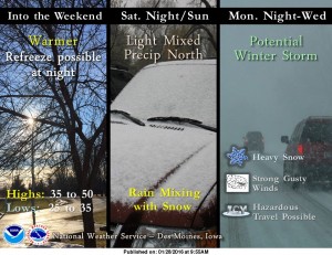
Today: Partly Cloudy. High around 40. NW @ 10-15.
Tonight: P/Cldy. Low 22. Winds light & variable.
Tomorrow: P/Cldy. High 47.
Saturday: P/Cldy. High around 47.
Sunday: Mostly Cloudy w/a chance of light rain. High 42.
Wednesday’s High in Atlantic was 37. The 24-hour Low ending at 7-a.m. today was 17. Last year on this date we reached 58 for a High and 30 was the low. The All-time Record High in Atlantic on this date was 58 in 1931 & 2015, while the Record Low was -23 in 1915.
EARLY THIS MORNING…CLEAR. NOT AS COLD. WEST WIND 10 TO 15 MPH WITH GUSTS TO AROUND 25 MPH.
TODAY…MOSTLY SUNNY. HIGH IN THE UPPER 30S. NORTHWEST WIND 10 TO 15 MPH WITH GUSTS TO AROUND 25 MPH.
TONIGHT…MOSTLY CLOUDY. LOW IN THE LOWER 20S. NORTHWEST WIND NEAR 10 MPH SHIFTING TO THE SOUTH AFTER MIDNIGHT.
FRIDAY…MOSTLY SUNNY UNTIL LATE AFTERNOON THEN BECOMING MOSTLY CLOUDY. HIGH IN THE MID 40S. SOUTH WIND 10 TO 15 MPH WITH GUSTS TO AROUND 25 MPH.
SATURDAY…MOSTLY CLOUDY. HIGH IN THE MID 40S. SOUTHWEST WIND 5 TO 15 MPH.
SUNDAY…MOSTLY CLOUDY WITH A 20 PERCENT CHANCE OF RAIN. HIGH IN THE LOWER 40S.
Today: Areas of fog before 9am. Otherwise, partly cloudy. High near 37. SW @ 15-20. Wind chill values as low as 5.
Tonight: Partly cloudy, with a low around 25. W/NW @ 10-15.
Tomorrow: P/Cldy. High near 37. W/NW @ 10-15.
Tom. Night: Partly cloudy, with a low around 22.
Friday: P/Cldy. High near 47. S/SW @ 10-20.
Saturday: P/Cldy. High again near 47.
Tuesday’s High in Atlantic was 29. The 24-hour Low ending at 7-a.m. today was 8. Last year on this date we reached 50 for a High and 21 was the low. The All-time Record High in Atlantic on this date was 61 in 1934, while the Record Low was -31 in 1902.
The National Weather Service says while temperatures will moderate through the weekend with highs from the mid 30s to around 50 through Sunday, a strong winter storm is likely next week. A couple of weak disturbances will affect Iowa today and Friday with the main impact being clouds and a slight chance of snow showers.
A strong winter storm is expected to develop over the Southwest U.S. into the Southern Plains then lift into the upper Midwest Tuesday through Wednesday. Officials say while it is too early too accurately assess track and timing, the storm will tap some gulf moisture and pull in a lot of cold air as it lifts Northeast. Moderate to heavy snowfall and strong winds are likely with this system. Watch and listen for updates on this developing storm system.
343 AM CST WED JAN 27 2016
EARLY THIS MORNING…PARTLY CLOUDY. AREAS OF FOG. SOUTHWEST WIND NEAR 5 MPH.
TODAY…MOSTLY SUNNY. PATCHY FOG THROUGH MID MORNING. HIGH IN THE UPPER 30S. SOUTHWEST WIND 5 TO 15 MPH WITH GUSTS TO AROUND 25 MPH.
TONIGHT…PARTLY CLOUDY. NOT AS COLD. LOW IN THE MID 20S. WEST WIND 10 TO 15 MPH.
THURSDAY…SUNNY. HIGH IN THE UPPER 30S. NORTHWEST WIND 10 TO 15 MPH.
FRIDAY…MOSTLY SUNNY. HIGH IN THE MID 40S. SOUTH WIND 10 TO 15 MPH.
SATURDAY…PARTLY SUNNY. HIGH IN THE MID 40S.
Today: Cloudy this morning; Partly Cloudy this afternoon. High around 30. NW @ 10-20. Tonight: P/Cldy. Winds light & variable. Low 10.
Tomorrow: Areas of fog possible early; P/Cldy. High 37. SW @ 15-30.
Thursday: P/Cldy. High around 37.
Friday: P/Cldy. High near 45.
Monday’s High in Atlantic was 29. We received .4” of snow Monday, along with freezing drizzle/light rain. The liquid value of the precipitation amounted to 02”. The 24-hour Low ending at 7-a.m. today was 22. Last year on this date we reached 53 for a High and 21 was the low. The All-time Record High in Atlantic on this date was 67 in 2002, while the Record Low was -24 in 1963.
SAC-CRAWFORD-CARROLL-AUDUBON-GUTHRIE-DALLAS-CASS-ADAIR-MADISON COUNTIES IN THE KJAN LISTENING AREA…(6:16-A.M.)
…ROADS MAY REMAIN SLICK FOR THE MORNING COMMUTE…
TRAVEL COULD STILL BE HAZARDOUS IN SPOTS THIS MORNING WITH ICING AND SNOW FROM MONDAY STILL ON THE ROADS…AND BRISK NORTHWEST WINDS PRODUCING AN ADDITIONAL COATING OF SHALLOW BLOWING SNOW OVERNIGHT. MOTORISTS ARE ADVISED TO SLOW DOWN…DRIVE DEFENSIVELY…AND PLAN FOR EXTRA TRAVEL TIME.


