
Today: Sunny, with a high near 18. N winds 5-15 mph w/gusts to near 2o. Wind chill values as low as -10.
Tonight: Mostly cloudy, with a low around 5. Light north northwest wind.
Tomorrow: Partly sunny, with a high near 21. N/NW winds 5-10. Wind chill values as low as zero.
Tom. Night: Partly cloudy, with a low around 1.
Wednesday: Sunny, with a high near 20.
Wednesday Night: Partly cloudy, with a low around 4.
Thursday: Partly sunny, with a high near 27.
Sunday’s High in Atlantic was 15. The Low was 4. Last year on this date (Jan. 6th), the High in Atlantic was 32 and the Low was 23. The Record High was 56 in 1933, and the Record Low was -24 in 1910. Sunrise: 7:46. Sunset: 5:05.
Today: Cloudy w/a 40% chance of snow. Patchy blowing snow between 11am and noon. High near 15. N/NE winds 15-30 mph. Wind chill values as low as -5. New snow accumulation of less than a half inch possible.
Tonight: Cloudy to partly cloudy w/a slight chance of snow before 8pm. Low around 2. Winds N @ 10-25 mph. Wind chill values as low as -10.
Monday: Mostly sunny, with a high near 18. Winds N @ 5-10. Wind chill values as low as -15.
Monday Night: Mostly cloudy, with a low around 3.
Tuesday: Partly sunny, with a high near 19.
Tuesday Night: Mostly clear, with a low around -2.
Wednesday: Sunny, with a high near 19.
Wednesday Night: Partly cloudy, with a low around 5.
Saturday’s High in Atlantic was 16. The Low was 9. We had a Trace of snow Saturday morning at KJAN. Last year on this date (Jan. 5th), the High in Atlantic was 34 and the Low was 24. The Record High was 62 in 2012, and the Record Low was -26 in 2010. Sunrise: 7:46. Sunset: 5:04.
Today: Cloudy w/a slight chance of flurries or light snow late this afternoon. High near 18. E/NE winds 5-10 mph. Wind chill values as low as zero.
Tonight: Snow likely, mainly after midnight. Low around 9. E/NE winds 10-15 mph. Wind chill values as low as -5. New snow accumulation of around an inch possible.
Tomorrow: A 50% chance of snow. High near 14. N winds 15-30 mph. Wind chill values as low as -10. New snow accumulation of less than a half inch possible.
Tom. Night: Mostly cloudy, with a low around 0. North winds 10-20 mph.
Monday: Mostly sunny, with a high near 17.
Monday Night: Mostly cloudy, with a low around 0.
Tuesday: Mostly sunny, with a high near 17.
Friday’s High in Atlantic was 19. The Low was 8. Last year on this date (1/4) the High in Atlantic was 33 and the Low was 20. The Record High was 59 in 1939, and the Record Low was -29 in 2010. Sunrise: 7:46; Sunset: 5:03.
(Radio Iowa) – The year 2024 wrapped up as one of Iowa’s worst in history for severe weather. State climatologist Justin Glisan says among the many incidents, a record was set for the most-ever tornadoes to touch down in Iowa during a calendar year.
That July derecho was devastating, but wasn’t nearly as severe as the one that blasted across Iowa in August of 2020, which caused some 11-billion dollars damage in Iowa and four other states. After several previous years of drought, parts of Iowa had record rainfall during 2024, which brought unprecedented results.
Hundreds of homes were lost to the flooding, while dozens of Iowa counties were declared state and federal disaster areas — between the flooding and tornadoes. Glisan says the unusual weather events continued into the latter part of the year.
As for what’s ahead, Glisan says long-range forecasts call for bitter cold for perhaps another two weeks, with high temperatures peaking 20 degrees colder than normal. He says the forecast models are still uncertain as to how much precipitation we may get.
Today: Partly sunny, with a high near 23. N/NW winds 5-10 mph. Wind chill values as low as 5.
Tonight: Mostly cloudy, with a low around 9.
Tomorrow: Cloudy w/a chance of flurries. A high near 18. N/NW winds @ 5-10 becoming E/NE. Wind chill values as low as zero.
Tom. Night: A 60% chance of snow likely, mainly after midnight. Low around 9. New snow accumulation of less than one inch is expected.
Sunday: Cloudy & blustery w/a 60% chance of snow, mainly before noon. High near 15. New snow amounting to 1-to 2-inches is possible.
Sunday Night: Mostly cloudy, with a low around 0.
Monday: Mostly sunny, with a high near 13.
Monday Night: Partly cloudy, with a low around -2.
Tuesday: Mostly sunny, with a high near 14.
Thursday’s High in Atlantic was 29. The Low was 8. Last year on this date (1/3) the High in Atlantic was 31 and the Low was 20. The Record High was 52 in 1933, and the Record Low was -30 in 2010. Sunrise: 7:46; Sunset: 5:02.
(Radio Iowa) – A Snow Squall Warning was issued this (Thursday) morning for parts of western and central Iowa, due to visibility being greatly reduced by heavy snow. The D-O-T says many roads across Iowa’s western half are completely snow-covered. National Weather Service meteorologist Brooke Hagenhof says the storm system is headed east, roughly following Highway 30 and Interstate 80. “We’re looking at between two to four inches of snow falling across the area this morning, it’s going to fall very quickly within that band,” Hagenhoff says. “The heaviest snow looks to be along or maybe just north of that I-80 corridor as it moves across the state of Iowa.” She says a second winter storm may be looming this weekend.
“We’re looking at another system that’s going to come very late Saturday night and then mainly through the day on Sunday,” Hagenhoff says. “We’re still working out the details on it, but right now, it does look like southern Iowa would be the most likely spot for that heavier snowfall. We’ll be fine tuning the forecast here in the days to come.” That system will leave behind much colder weather, as she says we’ll have high temperatures 15 to 20 degrees below normal. 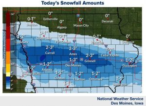
“We’re looking at temperatures for highs in the teens next week with overnight lows near or below zero,” Hagenhoff says. “Add on top of that, the wind chill, and it’s going to feel near or below zero for several days into next week.” Keep up with the changing forecast at weather-dot-gov.
Atlantic (KJAN), 1.2″ snow [.1″ liquid value]
Atlantic, 7-miles N/NE, 2.0″ snow [.1″ liquid value]
Massena, .5″ snow
8.3 miles W/NW of Creston, 5″ snow
Manning, .24″ precipitation
Mondamin, Logan & Persia (in Harrison County), 3″ of snow (precip. .15″ to .2″)
Council Bluffs, .5″ snow (.04″)
Kirkman, 2.8″ snow (.29)
Earling, 1.3″ snow (.12)
Oakland, 1.6″
Westphalia, 1.3″
Today: **WINTER WEATHER ADVISORY until Noon**Snow, mainly before 11am. High near 31. Winds becoming N/NE @ 5 to 10 mph. New snow accumulation of 1 to 4 inches possible.
Tonight: Partly cloudy, with a low around 10. Northwest wind around 5 mph.
Friday: Mostly sunny, with a high near 22. NW winds 5-10 mph. Wind chill values as low as zero.
Friday Night: Mostly cloudy, with a low around 9.
Saturday: Cloudy, with a high near 19.
Saturday Night: Snow likely, mainly after midnight. Cloudy, with a low around 8.
Sunday: Snow likely, mainly before noon. Cloudy, with a high near 16. Blustery.
Sunday Night: Mostly cloudy, with a low around 0.
Monday: Partly sunny, with a high near 14.
Wednesday’s High in Atlantic was 37. The Low was 20. Snow begin falling in Atlantic at around 4-a.m. today (as of 7-a.m. [24-hours] we had 1.2″ of snow on the ground w/a liquid value of .1″). Last year on this date (1/2) the High in Atlantic was 43 and the Low was 20. The Record High was 59 in 1939, and the Record Low was -24 in 2018. Sunrise: 7:46; Sunset: 5:01.
(Atlantic, Iowa – KJAN) – Weather data for the month of December, 2024, in Atlantic, shows we were warmer and drier than normal. The average High for the month was 39-degrees. The normal (average) high is 33. The average Low for December was 23, which was just 9-degrees above average. Precipitation for the month (rain & melted snow) amounted to .9 of an inch, which was a little more one-tenth of an inch below the norm of 1.1-inches. We received 7-tenths of an inch of snow altogether. The data was compiled at KJAN, the official National Weather Service reporting site for Atlantic.
Looking ahead, we find the High temperature for the month of January in Atlantic, is 29 degrees, while the average Low is 9. Precipitation typically amounts to .84-inches.
Check back with us during the first week of February, 2025, to see how our actual weather data compared to the historical averages.
Today: Mostly sunny, with a high near 32. West northwest wind 5 to 13 mph
Tonight: a 40 percent chance of snow, mainly after 5 am. Increasing clouds with a low around 23. Calm wind. New Snow accumulation of less than a half inch possible.
Thursday: Snow, mainly before noon. Temperature rising to near 30 by 10 am, then falling to around 23 the remainder of the day. Light and variable wind becoming northeast 5 to 9 mph in the morning. Chance of precipitation is 80%, New Snow accumulation of 1 to 3 inches is possible.
Thur. Night: Partly cloudy, with a low around 8. Northwest wind around 6 mph.
Friday: Mostly sunny, with a high near 20.
Friday Night: Partly cloudy, with a low around 5.
Saturday: Mostly cloudy, with a high near 18.
Sat. Night: A 40 percent chance of snow. Cloudy, with a low around 10.
Sunday: Snow likely, mainly before noon. Cloudy, with a high near 18. Chance of precipitation is 60%.


